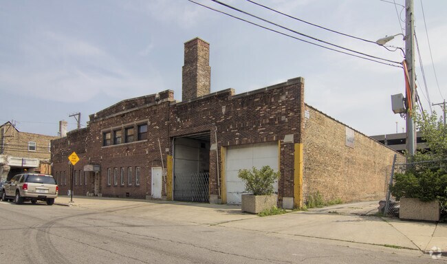
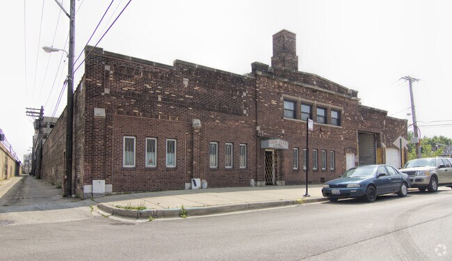
Property Record
1125 W Winona St, Chicago, IL 60640

NEARBY LISTINGS FOR SALE OR LEASE
Property Detail
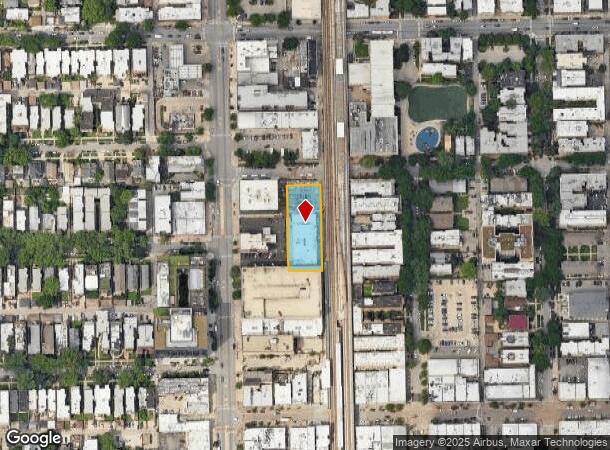
1125 W Winona St
Chicago-Naperville-Elgin, IL-IN-WI
Argyle Sub
14-08-404-003-0000
(ARGYLE) SUB A SUB OF LTS1-2 OF FUSSEY & FENNIMORES S UB & LTS1-2 OF COLEHOUR & CONARROES SUB OF LT3,ETC SEC 08-40-14
Apartment
Cook
X
Illinois
17031C0406K
1-3
2023
0.57 AC
2024
North Chicago
031200
Chicago
22,400 SF
DEMOGRAPHICS near 1125 W Winona St
1 Mile
3 Mile
5 Mile
2024 Total Population
78,384
425,798
816,322
2029 Population
76,357
411,834
787,500
Pop Growth 2024-2029
(2.59%)
(3.28%)
(3.53%)
Average Age
41
38
38
2024 Total Households
43,517
205,229
376,285
HH Growth 2024-2029
(2.88%)
(3.45%)
(3.66%)
Median Household Inc
$63,839
$74,783
$84,170
Avg Household Size
1.70
2.00
2.10
2024 Avg HH Vehicles
1.00
1.00
1.00
Median Home Value
$349,446
$402,427
$430,872
Median Year Built
1948
1949
1949
Nearby Places
- Restaurants
- Banks
- Shops
- Fitness
- Groceries
PUBLIC TRANSPORTATION
TRANSIT/SUBWAY
Argyle (Red Line - Chicago Transit Authority)
DRIVE
WALK
Distance
Argyle (Red Line - Chicago Transit Authority)
0 min
0 min
0.0 mi
Argyle Station (Red Line - Chicago Transit Authority "L" Trains (The "L"))
DRIVE
WALK
Distance
Argyle Station (Red Line - Chicago Transit Authority "L" Trains (The "L"))
1 min
2 min
0.1 mi
Bryn Mawr Station (Red Line - Chicago Transit Authority "L" Trains (The "L"))
DRIVE
WALK
Distance
Bryn Mawr Station (Red Line - Chicago Transit Authority "L" Trains (The "L"))
2 min
12 min
0.6 mi
Wilson-North Inner (Purple Line - Chicago Transit Authority, Red Line - Chicago Transit Authority)
DRIVE
WALK
Distance
Wilson-North Inner (Purple Line - Chicago Transit Authority, Red Line - Chicago Transit Authority)
3 min
17 min
0.9 mi
Thorndale Station (Red Line - Chicago Transit Authority "L" Trains (The "L"))
DRIVE
WALK
Distance
Thorndale Station (Red Line - Chicago Transit Authority "L" Trains (The "L"))
3 min
20 min
1.1 mi
COMMUTER RAIL
Ravenswood Station (Union Pacific North Line - Northeast Illinois Regional Commuter Railroad (Metra))
DRIVE
WALK
Distance
Ravenswood Station (Union Pacific North Line - Northeast Illinois Regional Commuter Railroad (Metra))
4 min
1.7 mi
Peterson/Ridge (Union Pacific North - Metra)
DRIVE
WALK
Distance
Peterson/Ridge (Union Pacific North - Metra)
4 min
1.7 mi
AIRPORT
Chicago O'Hare International
DRIVE
WALK
Distance
Chicago O'Hare International
25 min
13.9 mi
Chicago Midway International
DRIVE
WALK
Distance
Chicago Midway International
29 min
19.4 mi
Freight Ports
Port Milwaukee
DRIVE
WALK
Distance
Port Milwaukee
101 min
79.8 mi
Nearby Properties
Address
Land Use
TOTAL SIZE
Lot Size
Zoning
Address
Land Use
TOTAL SIZE
Lot Size
Zoning
0.63 AC
PD 1372
Address
Land Use
TOTAL SIZE
Lot Size
Zoning
228,018 SF
8.72 AC
PD 958
Address
Land Use
TOTAL SIZE
Lot Size
Zoning
0.96 AC
PD 958
Address
Land Use
TOTAL SIZE
Lot Size
Zoning
16.93 AC
POS-1,PD 1
Address
Land Use
TOTAL SIZE
Lot Size
Zoning
301,100 SF
2.20 AC
PD 37
Address
Land Use
TOTAL SIZE
Lot Size
Zoning
1 AC
RS-3
Address
Land Use
TOTAL SIZE
Lot Size
Zoning
147,835 SF
1.03 AC
PD 37
Address
Land Use
TOTAL SIZE
Lot Size
Zoning
170,538 SF
0.76 AC
PD 112
Address
Land Use
TOTAL SIZE
Lot Size
Zoning
331,294 SF
13.03 AC
PD 439
Address
Land Use
TOTAL SIZE
Lot Size
Zoning
201,600 SF
1.93 AC
PD 92
Address
Land Use
TOTAL SIZE
Lot Size
Zoning
2.25 AC
PD 612
Address
Land Use
TOTAL SIZE
Lot Size
Zoning
162,700 SF
0.64 AC
PD 50
Address
Land Use
TOTAL SIZE
Lot Size
Zoning
140,451 SF
9.48 AC
PD 213
Address
Land Use
TOTAL SIZE
Lot Size
Zoning
1.35 AC
PD 1194
Address
Land Use
TOTAL SIZE
Lot Size
Zoning
226,345 SF
3.71 AC
PD 1203
Address
Land Use
TOTAL SIZE
Lot Size
Zoning
144,865 SF
0.21 AC
Address
Land Use
TOTAL SIZE
Lot Size
Zoning
0.88 AC
RM-6.5
Address
Land Use
TOTAL SIZE
Lot Size
Zoning
340,838 SF
31 AC
PD 1411
Address
Land Use
TOTAL SIZE
Lot Size
Zoning
197,785 SF
4.03 AC
PD 943
Address
Land Use
TOTAL SIZE
Lot Size
Zoning
32,200 SF
5.67 AC
B3-5,RM-6.
Address
Land Use
TOTAL SIZE
Lot Size
Zoning
29,700 SF
0.68 AC
PD 1253
Address
Land Use
TOTAL SIZE
Lot Size
Zoning
335,900 SF
0.99 AC
RM-6.5
Address
Land Use
TOTAL SIZE
Lot Size
Zoning
150,448 SF
0.96 AC
PD 958
Address
Land Use
TOTAL SIZE
Lot Size
Zoning
1.57 AC
PD 1052
Address
Land Use
TOTAL SIZE
Lot Size
Zoning
0.64 AC
PD 958
Address
Land Use
TOTAL SIZE
Lot Size
Zoning
24,400 SF
0.50 AC
B3-2
Address
Land Use
TOTAL SIZE
Lot Size
Zoning
5.48 AC
RT-4,PD 10
Address
Land Use
TOTAL SIZE
Lot Size
Zoning
1.01 AC
RM-6,POS-1
Address
Land Use
TOTAL SIZE
Lot Size
Zoning
0.16 AC
RM-6
Address
Land Use
TOTAL SIZE
Lot Size
Zoning
0.49 AC
RM-6.5
The World's #1 Commercial Real Estate Marketplace
Connect with us
© 2025 CoStar Group
The information above has been obtained from sources believed reliable. While we do not doubt its accuracy we have not verified it and make no guarantee, warranty or representation about it. It is your responsibility to independently confirm its accuracy and completeness. Any projections, opinions, assumptions, or estimates used are for example only and do not represent the current or future performance of the property. The value of this transaction to you depends on tax and other factors which should be evaluated by your tax, financial, and legal advisors. You and your advisors should conduct a careful, independent investigation of the property to determine to your satisfaction the suitability of the property for your needs.