Property Record
11351 Nuckols Rd, Glen Allen, VA 23059


NEARBY LISTINGS FOR SALE OR LEASE
Property Detail
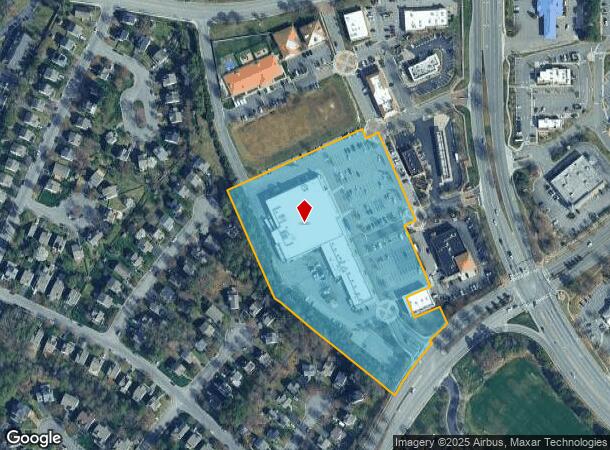
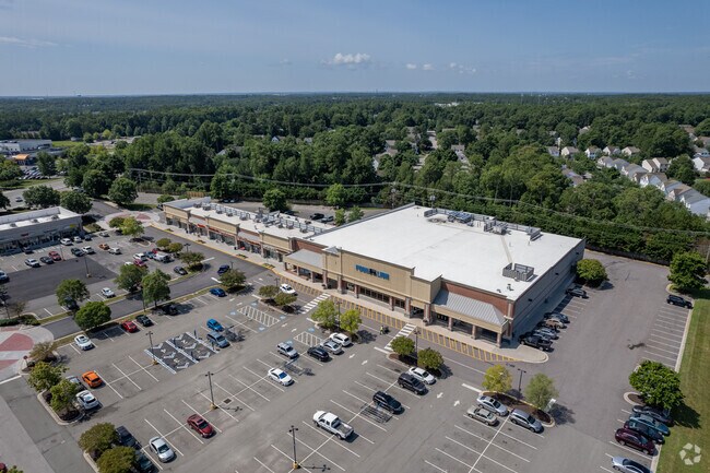
11351 Nuckols Rd
746-772-0397
Acreage
Regionalshoppingcenterormallwithanchorstore
00180A0000 0022F; TWIN HICKORY RD AC 7.039 76 A2 48
X
Henrico
51085C0287C
Virginia
0
7.04 AC
2025
Far West End North
200148
Richmond VA
54,079 SF
Richmond, VA
DEMOGRAPHICS near 11351 Nuckols Rd
1 Mile
3 Mile
5 Mile
2024 Total Population
9,384
51,342
128,216
2029 Population
9,343
51,248
128,312
Pop Growth 2024-2029
(0.44%)
(0.18%)
+ 0.07%
Average Age
36
37
40
2024 Total Households
3,123
18,421
49,619
HH Growth 2024-2029
(0.42%)
(0.18%)
+ 0.06%
Median Household Inc
$160,538
$142,064
$109,121
Avg Household Size
3.00
2.80
2.50
2024 Avg HH Vehicles
2.00
2.00
2.00
Median Home Value
$559,149
$488,981
$416,215
Median Year Built
2004
1999
1992
Nearby Places
Map Layers
Map Styles
 Street
 Aerial
- Restaurants
- Banks
- Shops
- Fitness
- Groceries
PUBLIC TRANSPORTATION
COMMUTER RAIL
Richmond Staples Mill Road Amtrak Station (Carolinian - Amtrak, Northeast Regional - Amtrak, Palmetto - Amtrak, Silver Meteor - Amtrak)
DRIVE
WALK
Distance
Richmond Staples Mill Road Amtrak Station (Carolinian - Amtrak, Northeast Regional - Amtrak, Palmetto - Amtrak, Silver Meteor - Amtrak)
15 min
9.2 mi
AIRPORT
Richmond International
DRIVE
WALK
Distance
Richmond International
36 min
26.8 mi
Freight Ports
Virginia Port Authority - Richmond
DRIVE
WALK
Distance
Virginia Port Authority - Richmond
34 min
23.5 mi
Nearby Properties
Address
Land Use
TOTAL SIZE
Lot Size
Zoning
Address
Land Use
TOTAL SIZE
Lot Size
Zoning
10,290 SF
56.53 AC
B-3C
Address
Land Use
TOTAL SIZE
Lot Size
Zoning
37.36 AC
R-5C
Address
Land Use
TOTAL SIZE
Lot Size
Zoning
112,224 SF
20.53 AC
MIXE
Address
Land Use
TOTAL SIZE
Lot Size
Zoning
57,104 SF
0.02 AC
UMUC
Address
Land Use
TOTAL SIZE
Lot Size
Zoning
403,784 SF
40.74 AC
MIXE
Address
Land Use
TOTAL SIZE
Lot Size
Zoning
417,042 SF
49.96 AC
O-3C
Address
Land Use
TOTAL SIZE
Lot Size
Zoning
254,325 SF
60.28 AC
A-1
Address
Land Use
TOTAL SIZE
Lot Size
Zoning
340 SF
23.32 AC
MIXE
Address
Land Use
TOTAL SIZE
Lot Size
Zoning
252,912 SF
28.54 AC
R-6
Address
Land Use
TOTAL SIZE
Lot Size
Zoning
278,084 SF
21.70 AC
R-6C
Address
Land Use
TOTAL SIZE
Lot Size
Zoning
309,156 SF
17.13 AC
R-6
Address
Land Use
TOTAL SIZE
Lot Size
Zoning
306,040 SF
32.24 AC
R-5
Address
Land Use
TOTAL SIZE
Lot Size
Zoning
282,400 SF
18.71 AC
MIXE
Address
Land Use
TOTAL SIZE
Lot Size
Zoning
289,752 SF
24.72 AC
R-5C
Address
Land Use
TOTAL SIZE
Lot Size
Zoning
159,980 SF
21.38 AC
R-5C
Address
Land Use
TOTAL SIZE
Lot Size
Zoning
5.43 AC
UMUC
Address
Land Use
TOTAL SIZE
Lot Size
Zoning
7.98 AC
UMUC
Address
Land Use
TOTAL SIZE
Lot Size
Zoning
138,713 SF
46.53 AC
A-1
Address
Land Use
TOTAL SIZE
Lot Size
Zoning
243,357 SF
32.34 AC
MIXE
Address
Land Use
TOTAL SIZE
Lot Size
Zoning
182,264 SF
15.91 AC
R-5
Address
Land Use
TOTAL SIZE
Lot Size
Zoning
382,944 SF
18.17 AC
M-1
Address
Land Use
TOTAL SIZE
Lot Size
Zoning
326,755 SF
36.20 AC
O-3C
Address
Land Use
TOTAL SIZE
Lot Size
Zoning
5,590 SF
11.54 AC
B-2C
Address
Land Use
TOTAL SIZE
Lot Size
Zoning
329,044 SF
8.09 AC
UMUC
Address
Land Use
TOTAL SIZE
Lot Size
Zoning
156,332 SF
15.27 AC
R-5
Address
Land Use
TOTAL SIZE
Lot Size
Zoning
358,228 SF
3.30 AC
UMUC
Address
Land Use
TOTAL SIZE
Lot Size
Zoning
312,719 SF
18.47 AC
M-1C
Address
Land Use
TOTAL SIZE
Lot Size
Zoning
55,769 SF
14.13 AC
MIXE
Address
Land Use
TOTAL SIZE
Lot Size
Zoning
111,487 SF
2.92 AC
B-2C
Address
Land Use
TOTAL SIZE
Lot Size
Zoning
23,378 SF
0.02 AC
UMUC
The World's #1 Commercial Real Estate Marketplace
Connect with us
© 2026 CoStar Group
The information above has been obtained from sources believed reliable. While we do not doubt its accuracy we have not verified it and make no guarantee, warranty or representation about it. It is your responsibility to independently confirm its accuracy and completeness. Any projections, opinions, assumptions, or estimates used are for example only and do not represent the current or future performance of the property. The value of this transaction to you depends on tax and other factors which should be evaluated by your tax, financial, and legal advisors. You and your advisors should conduct a careful, independent investigation of the property to determine to your satisfaction the suitability of the property for your needs.