Property Record
11355 W 97Th Ln, Saint John, IN 46373
Current Lease Availabilities
NEARBY LISTINGS FOR SALE OR LEASE
Property Detail
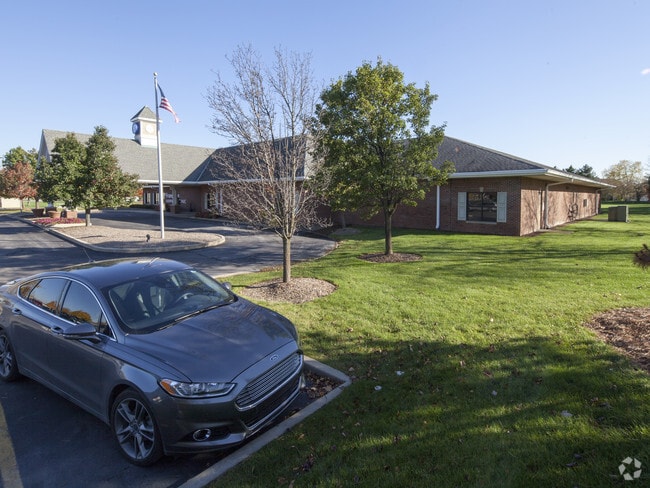
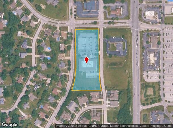
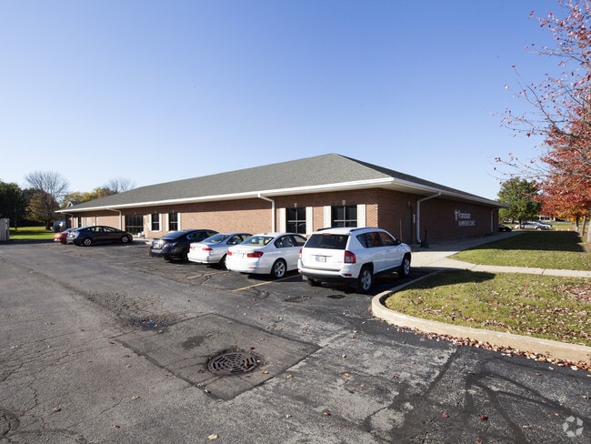
11355 W 97Th Ln
Chicago-Naperville-Elgin, IL-IN-WI
Hammond Clinic (St. John)
45-11-32-430-001.000-035
HAMMOND CLINIC (ST. JOHN) LOT 1
Medicalbuilding
Lake
X
Indiana
18089C0228E
1
2024
2.41 AC
2025
Indiana
042608
Chicago
20,270 SF
DEMOGRAPHICS near 11355 W 97Th Ln
1 Mile
3 Mile
5 Mile
2024 Total Population
4,133
33,497
82,517
2029 Population
4,128
33,856
82,691
Pop Growth 2024-2029
(0.12%)
+ 1.07%
+ 0.21%
Average Age
45
42
42
2024 Total Households
1,564
12,152
31,331
HH Growth 2024-2029
(0.13%)
+ 1.08%
+ 0.15%
Median Household Inc
$104,976
$110,647
$94,651
Avg Household Size
2.60
2.70
2.60
2024 Avg HH Vehicles
2.00
2.00
2.00
Median Home Value
$304,127
$320,187
$284,141
Median Year Built
1991
1999
1992
Nearby Places
Map Layers
Map Styles
 Street
 Aerial
- Restaurants
- Banks
- Shops
- Fitness
- Groceries
PUBLIC TRANSPORTATION
COMMUTER RAIL
Dyer Amtrak (Cardinal - Amtrak)
DRIVE
WALK
Distance
Dyer Amtrak (Cardinal - Amtrak)
16 min
7.7 mi
AIRPORT
Chicago Midway International
DRIVE
WALK
Distance
Chicago Midway International
58 min
36.0 mi
Freight Ports
Port Milwaukee
DRIVE
WALK
Distance
Port Milwaukee
161 min
122.2 mi
Nearby Properties
Address
Land Use
TOTAL SIZE
Lot Size
Zoning
Address
Land Use
TOTAL SIZE
Lot Size
Zoning
218,510 SF
14.96 AC
Address
Land Use
TOTAL SIZE
Lot Size
Zoning
100,880 SF
37 AC
Address
Land Use
TOTAL SIZE
Lot Size
Zoning
113,545 SF
22.54 AC
Address
Land Use
TOTAL SIZE
Lot Size
Zoning
41,867 SF
15.17 AC
R3
Address
Land Use
TOTAL SIZE
Lot Size
Zoning
67,446 SF
10.02 AC
R33
Address
Land Use
TOTAL SIZE
Lot Size
Zoning
56,832 SF
27.54 AC
Address
Land Use
TOTAL SIZE
Lot Size
Zoning
89,872 SF
16.15 AC
Address
Land Use
TOTAL SIZE
Lot Size
Zoning
156,258 SF
4.80 AC
Address
Land Use
TOTAL SIZE
Lot Size
Zoning
68,634 SF
6.84 AC
R33
Address
Land Use
TOTAL SIZE
Lot Size
Zoning
124,474 SF
12.29 AC
R33
Address
Land Use
TOTAL SIZE
Lot Size
Zoning
12,962 SF
14.12 AC
Address
Land Use
TOTAL SIZE
Lot Size
Zoning
33,683 SF
15.70 AC
R3
Address
Land Use
TOTAL SIZE
Lot Size
Zoning
28,298 SF
26.78 AC
Address
Land Use
TOTAL SIZE
Lot Size
Zoning
32,826 SF
1.73 AC
Address
Land Use
TOTAL SIZE
Lot Size
Zoning
18,000 SF
2.60 AC
R3
Address
Land Use
TOTAL SIZE
Lot Size
Zoning
18.17 AC
Address
Land Use
TOTAL SIZE
Lot Size
Zoning
83,401 SF
10.28 AC
Address
Land Use
TOTAL SIZE
Lot Size
Zoning
19,992 SF
6.71 AC
R33
Address
Land Use
TOTAL SIZE
Lot Size
Zoning
47,176 SF
5.65 AC
Address
Land Use
TOTAL SIZE
Lot Size
Zoning
33,800 SF
2.98 AC
R3
Address
Land Use
TOTAL SIZE
Lot Size
Zoning
55,951 SF
5.50 AC
Address
Land Use
TOTAL SIZE
Lot Size
Zoning
9,696 SF
1.54 AC
Address
Land Use
TOTAL SIZE
Lot Size
Zoning
77,688 SF
3.68 AC
R33
Address
Land Use
TOTAL SIZE
Lot Size
Zoning
13,500 SF
32.23 AC
Address
Land Use
TOTAL SIZE
Lot Size
Zoning
28,416 SF
6.06 AC
Address
Land Use
TOTAL SIZE
Lot Size
Zoning
17 AC
Address
Land Use
TOTAL SIZE
Lot Size
Zoning
8.36 AC
Address
Land Use
TOTAL SIZE
Lot Size
Zoning
27,394 SF
3.26 AC
R33
Address
Land Use
TOTAL SIZE
Lot Size
Zoning
44,400 SF
7.46 AC
The World's #1 Commercial Real Estate Marketplace
Connect with us
© 2026 CoStar Group
The information above has been obtained from sources believed reliable. While we do not doubt its accuracy we have not verified it and make no guarantee, warranty or representation about it. It is your responsibility to independently confirm its accuracy and completeness. Any projections, opinions, assumptions, or estimates used are for example only and do not represent the current or future performance of the property. The value of this transaction to you depends on tax and other factors which should be evaluated by your tax, financial, and legal advisors. You and your advisors should conduct a careful, independent investigation of the property to determine to your satisfaction the suitability of the property for your needs.