Property Record
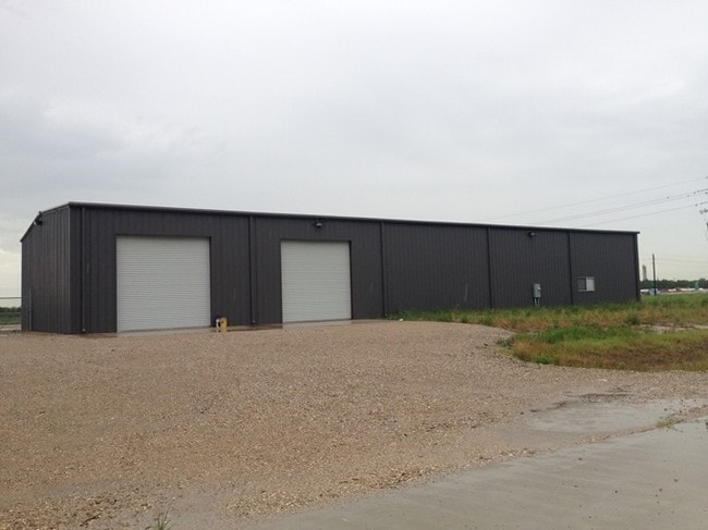
11356 Interstate 10 E, Baytown, TX 77523


NEARBY LISTINGS FOR SALE OR LEASE
Property Detail
11356 Interstate 10 E
Houston-Pasadena-The Woodlands, TX
Usa Industrial Park
60110-00321-00100-000100
LT 1 BK 1 USA INDUSTRIAL PARK FINAL REPLAT CAGI P/U BLDGS
Industrialgeneral
Chambers
X
Texas
48071C0160F
1
2025
2.78 AC
2025
East-Southeast Far
710201
Houston
DEMOGRAPHICS near 11356 Interstate 10 E
1 Mile
3 Mile
5 Mile
2024 Total Population
859
23,026
46,804
2029 Population
1,107
29,259
57,808
Pop Growth 2024-2029
+ 28.87%
+ 27.07%
+ 23.51%
Average Age
33
35
36
2024 Total Households
267
7,346
15,151
HH Growth 2024-2029
+ 28.84%
+ 27.13%
+ 23.43%
Median Household Inc
$139,743
$112,662
$101,848
Avg Household Size
3.20
3.10
3.10
2024 Avg HH Vehicles
2.00
2.00
2.00
Median Home Value
$247,297
$264,719
$284,388
Median Year Built
2010
2009
2007
Nearby Places
Map Layers
Map Styles
 Street
 Aerial
- Restaurants
- Banks
- Shops
- Fitness
- Groceries
PUBLIC TRANSPORTATION
AIRPORT
William P Hobby
DRIVE
WALK
Distance
William P Hobby
54 min
37.5 mi
George Bush Intcntl/Houston
DRIVE
WALK
Distance
George Bush Intcntl/Houston
51 min
41.6 mi
Freight Ports
Port of Houston
DRIVE
WALK
Distance
Port of Houston
40 min
29.5 mi
SALE & LEASE HISTORY
LISTING DATE
SALE/LEASE

Feb 16, 2021
For Sale
Nearby Properties
Address
Land Use
TOTAL SIZE
Lot Size
Zoning
Address
Land Use
TOTAL SIZE
Lot Size
Zoning
0.58 AC
Address
Land Use
TOTAL SIZE
Lot Size
Zoning
63,224 SF
738.31 AC
Address
Land Use
TOTAL SIZE
Lot Size
Zoning
738.47 AC
Address
Land Use
TOTAL SIZE
Lot Size
Zoning
463.62 AC
Address
Land Use
TOTAL SIZE
Lot Size
Zoning
738.31 AC
Address
Land Use
TOTAL SIZE
Lot Size
Zoning
Address
Land Use
TOTAL SIZE
Lot Size
Zoning
Address
Land Use
TOTAL SIZE
Lot Size
Zoning
738.47 AC
Address
Land Use
TOTAL SIZE
Lot Size
Zoning
504,680 SF
29.61 AC
Address
Land Use
TOTAL SIZE
Lot Size
Zoning
194,400 SF
53.79 AC
Address
Land Use
TOTAL SIZE
Lot Size
Zoning
133,873 SF
12.26 AC
Address
Land Use
TOTAL SIZE
Lot Size
Zoning
22,375 SF
12.13 AC
Address
Land Use
TOTAL SIZE
Lot Size
Zoning
58,493 SF
18.49 AC
Address
Land Use
TOTAL SIZE
Lot Size
Zoning
738.47 AC
Address
Land Use
TOTAL SIZE
Lot Size
Zoning
11,189 SF
7.40 AC
Address
Land Use
TOTAL SIZE
Lot Size
Zoning
3,900 SF
42.94 AC
Address
Land Use
TOTAL SIZE
Lot Size
Zoning
13,927 SF
23.39 AC
Address
Land Use
TOTAL SIZE
Lot Size
Zoning
9,087 SF
6.98 AC
Address
Land Use
TOTAL SIZE
Lot Size
Zoning
222,375 SF
42.92 AC
Address
Land Use
TOTAL SIZE
Lot Size
Zoning
34,504 SF
9.19 AC
Address
Land Use
TOTAL SIZE
Lot Size
Zoning
42.79 AC
Address
Land Use
TOTAL SIZE
Lot Size
Zoning
187,383 SF
18.95 AC
Address
Land Use
TOTAL SIZE
Lot Size
Zoning
9,627 SF
6.91 AC
Address
Land Use
TOTAL SIZE
Lot Size
Zoning
2,239 SF
9.15 AC
Address
Land Use
TOTAL SIZE
Lot Size
Zoning
46.88 AC
Address
Land Use
TOTAL SIZE
Lot Size
Zoning
21,000 SF
51.28 AC
Address
Land Use
TOTAL SIZE
Lot Size
Zoning
68.73 AC
Address
Land Use
TOTAL SIZE
Lot Size
Zoning
24.90 AC
Address
Land Use
TOTAL SIZE
Lot Size
Zoning
34.88 AC
The World's #1 Commercial Real Estate Marketplace
Connect with us
© 2026 CoStar Group
The information above has been obtained from sources believed reliable. While we do not doubt its accuracy we have not verified it and make no guarantee, warranty or representation about it. It is your responsibility to independently confirm its accuracy and completeness. Any projections, opinions, assumptions, or estimates used are for example only and do not represent the current or future performance of the property. The value of this transaction to you depends on tax and other factors which should be evaluated by your tax, financial, and legal advisors. You and your advisors should conduct a careful, independent investigation of the property to determine to your satisfaction the suitability of the property for your needs.