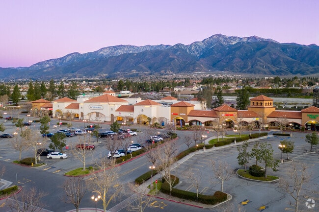
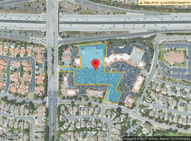
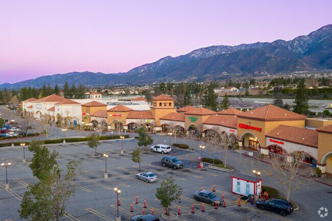
Property Record
11358 Kenyon Way, Rancho Cucamonga, CA 91701
NEARBY LISTINGS FOR SALE OR LEASE
Property Detail
11358 Kenyon Way
1089-131-06
Parcel Map 12263
Supermarket
PARCEL MAP 12263 PARCEL 6 PARCEL MAP 12263 PARCEL NO 6
X
San Bernardino
06071C7895J
California
2024
3.91 AC
2025
Airport Area
002031
Inland Empire (California)
42,562 SF
Riverside-San Bernardino-Ontario, CA
DEMOGRAPHICS near 11358 Kenyon Way
1 Mile
3 Mile
5 Mile
2024 Total Population
18,319
119,159
241,416
2029 Population
18,495
120,782
245,113
Pop Growth 2024-2029
+ 0.96%
+ 1.36%
+ 1.53%
Average Age
39
39
38
2024 Total Households
5,891
40,415
78,195
HH Growth 2024-2029
+ 0.98%
+ 1.35%
+ 1.59%
Median Household Inc
$114,140
$105,569
$102,961
Avg Household Size
3.10
2.90
3.00
2024 Avg HH Vehicles
2.00
2.00
2.00
Median Home Value
$714,753
$678,362
$647,318
Median Year Built
1986
1988
1988
Nearby Places
Map Layers
Map Styles
 Street
 Aerial
- Restaurants
- Banks
- Shops
- Fitness
- Groceries
PUBLIC TRANSPORTATION
COMMUTER RAIL
Rancho Cucamonga (San Bernardino Line - Southern California Regional Rail Authority (Metrolink))
DRIVE
WALK
Distance
Rancho Cucamonga (San Bernardino Line - Southern California Regional Rail Authority (Metrolink))
6 min
3.5 mi
Upland (San Bernardino Line - Southern California Regional Rail Authority (Metrolink))
DRIVE
WALK
Distance
Upland (San Bernardino Line - Southern California Regional Rail Authority (Metrolink))
13 min
8.0 mi
AIRPORT
Ontario International
DRIVE
WALK
Distance
Ontario International
14 min
7.9 mi
Freight Ports
Port of Long Beach
DRIVE
WALK
Distance
Port of Long Beach
71 min
58.5 mi
Nearby Properties
Address
Land Use
TOTAL SIZE
Lot Size
Zoning
Address
Land Use
TOTAL SIZE
Lot Size
Zoning
502,314 SF
40.06 AC
Address
Land Use
TOTAL SIZE
Lot Size
Zoning
275,783 SF
11.82 AC
Address
Land Use
TOTAL SIZE
Lot Size
Zoning
261,114 SF
11.23 AC
Address
Land Use
TOTAL SIZE
Lot Size
Zoning
293,860 SF
16.10 AC
Address
Land Use
TOTAL SIZE
Lot Size
Zoning
145,111 SF
48.01 AC
Address
Land Use
TOTAL SIZE
Lot Size
Zoning
249,658 SF
20.03 AC
Address
Land Use
TOTAL SIZE
Lot Size
Zoning
611,573 SF
26.64 AC
Address
Land Use
TOTAL SIZE
Lot Size
Zoning
314,580 SF
24 AC
Address
Land Use
TOTAL SIZE
Lot Size
Zoning
190,724 SF
10.69 AC
Address
Land Use
TOTAL SIZE
Lot Size
Zoning
278,453 SF
4.73 AC
Address
Land Use
TOTAL SIZE
Lot Size
Zoning
174,092 SF
4.42 AC
Address
Land Use
TOTAL SIZE
Lot Size
Zoning
Address
Land Use
TOTAL SIZE
Lot Size
Zoning
84,378 SF
15.32 AC
Address
Land Use
TOTAL SIZE
Lot Size
Zoning
185,480 SF
16.81 AC
Address
Land Use
TOTAL SIZE
Lot Size
Zoning
139,059 SF
20.83 AC
Address
Land Use
TOTAL SIZE
Lot Size
Zoning
122,563 SF
5.76 AC
Address
Land Use
TOTAL SIZE
Lot Size
Zoning
225,727 SF
7.18 AC
Address
Land Use
TOTAL SIZE
Lot Size
Zoning
354,616 SF
20.07 AC
Address
Land Use
TOTAL SIZE
Lot Size
Zoning
131,190 SF
6.71 AC
Address
Land Use
TOTAL SIZE
Lot Size
Zoning
312,075 SF
14.20 AC
Address
Land Use
TOTAL SIZE
Lot Size
Zoning
468,410 SF
22.71 AC
Address
Land Use
TOTAL SIZE
Lot Size
Zoning
309,265 SF
18.65 AC
Address
Land Use
TOTAL SIZE
Lot Size
Zoning
443,300 SF
23.06 AC
Address
Land Use
TOTAL SIZE
Lot Size
Zoning
441,970 SF
20.58 AC
Address
Land Use
TOTAL SIZE
Lot Size
Zoning
331,872 SF
14.50 AC
Address
Land Use
TOTAL SIZE
Lot Size
Zoning
449,370 SF
21.05 AC
Address
Land Use
TOTAL SIZE
Lot Size
Zoning
127,559 SF
5.63 AC
Address
Land Use
TOTAL SIZE
Lot Size
Zoning
133,051 SF
11.04 AC
Address
Land Use
TOTAL SIZE
Lot Size
Zoning
240,401 SF
15.08 AC
Address
Land Use
TOTAL SIZE
Lot Size
Zoning
324,131 SF
19.81 AC
The World's #1 Commercial Real Estate Marketplace
Connect with us
© 2025 CoStar Group
The information above has been obtained from sources believed reliable. While we do not doubt its accuracy we have not verified it and make no guarantee, warranty or representation about it. It is your responsibility to independently confirm its accuracy and completeness. Any projections, opinions, assumptions, or estimates used are for example only and do not represent the current or future performance of the property. The value of this transaction to you depends on tax and other factors which should be evaluated by your tax, financial, and legal advisors. You and your advisors should conduct a careful, independent investigation of the property to determine to your satisfaction the suitability of the property for your needs.