Property Record
1136 E Borgfeld Dr, San Antonio, TX 78260
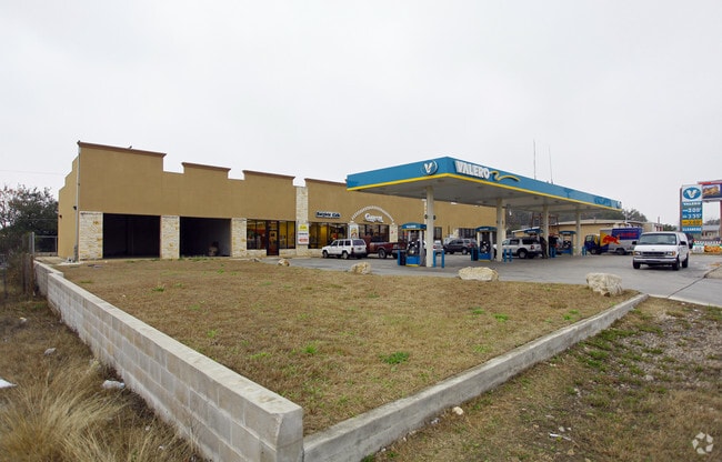

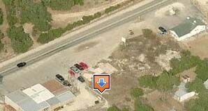

Property Detail
1136 E Borgfeld Dr
San Antonio-New Braunfels, TX
CB 4852A BLK 4 LOT 13 & 14 PROPERTY MERGE PER CR#21636 FOR 2010
04852-104-0130
BEXAR
Regionalshoppingcenterormallwithanchorstore
Texas
B and X Area of moderate flood hazard, usually the area between the limits of the 100-year and 500-year floods.
13
2024
0.64 AC
2025
Far North Central
191814
San Antonio
33,280 SF
NEARBY LISTINGS FOR SALE OR LEASE
-
-
-
-
-
No Photo
-
View all San Antonio listings for lease on LoopNet.com
DEMOGRAPHICS near 1136 E Borgfeld Dr
1 mile
3 mile
5 mile
2025 Total Population
4,810
34,787
90,183
2030 Population
5,186
37,447
96,996
Pop Growth 2025-2030
+ 7.82%
+ 7.65%
+ 7.55%
Average Age
38
39
38
2025 Total Households
1,579
11,742
30,126
HH Growth 2025-2030
+ 7.85%
+ 7.78%
+ 7.81%
Median Household Inc
$124,110
$138,594
$135,932
Avg Household Size
3.00
2.90
3.00
2025 Avg HH Vehicles
2.00
2.00
2.00
Median Home Value
$438,059
$469,841
$472,355
Median Year Built
2010
2008
2008
Nearby Places
Map Layers
Map Styles
 Street
 Aerial
Layers
 Traffic
 Biking
Places
Listings with unknown addresses are not visible on the map
- Restaurants
- Banks
- Shops
- Fitness
- Groceries
PUBLIC TRANSPORTATION
AIRPORT
San Antonio International
Drive
Walk
Distance
San Antonio International
20 min
15.8 mi
Freight Ports
Calhoun Port
Drive
Walk
Distance
Calhoun Port
198 min
164.5 mi
SALE & LEASE HISTORY
LISTING DATE
SALE/LEASE

Sep 25, 2016
For Lease
Nearby Properties
Address
Land Use
TOTAL SIZE
Lot Size
Zoning
Address
Land Use
TOTAL SIZE
Lot Size
Zoning
310,384 SF
14.25 AC
Address
Land Use
TOTAL SIZE
Lot Size
Zoning
123,938 SF
27.21 AC
Address
Land Use
TOTAL SIZE
Lot Size
Zoning
296,413 SF
15 AC
Address
Land Use
TOTAL SIZE
Lot Size
Zoning
35,888 SF
6.06 AC
Address
Land Use
TOTAL SIZE
Lot Size
Zoning
66,166 SF
85.74 AC
Address
Land Use
TOTAL SIZE
Lot Size
Zoning
54,150 SF
3.47 AC
Address
Land Use
TOTAL SIZE
Lot Size
Zoning
28.60 AC
Address
Land Use
TOTAL SIZE
Lot Size
Zoning
25.20 AC
Address
Land Use
TOTAL SIZE
Lot Size
Zoning
Address
Land Use
TOTAL SIZE
Lot Size
Zoning
20.13 AC
Address
Land Use
TOTAL SIZE
Lot Size
Zoning
74,320 SF
4.55 AC
Address
Land Use
TOTAL SIZE
Lot Size
Zoning
76,120 SF
3.90 AC
Address
Land Use
TOTAL SIZE
Lot Size
Zoning
20.95 AC
Address
Land Use
TOTAL SIZE
Lot Size
Zoning
Address
Land Use
TOTAL SIZE
Lot Size
Zoning
183.24 AC
Address
Land Use
TOTAL SIZE
Lot Size
Zoning
19.32 AC
Address
Land Use
TOTAL SIZE
Lot Size
Zoning
8,740 SF
6.36 AC
Address
Land Use
TOTAL SIZE
Lot Size
Zoning
17,000 SF
1.77 AC
Address
Land Use
TOTAL SIZE
Lot Size
Zoning
134.81 AC
Address
Land Use
TOTAL SIZE
Lot Size
Zoning
71,743 SF
6.87 AC
Address
Land Use
TOTAL SIZE
Lot Size
Zoning
6,590 SF
211.63 AC
Address
Land Use
TOTAL SIZE
Lot Size
Zoning
9,280 SF
3.93 AC
Address
Land Use
TOTAL SIZE
Lot Size
Zoning
2,021 SF
18.28 AC
Address
Land Use
TOTAL SIZE
Lot Size
Zoning
15,966 SF
1.72 AC
Address
Land Use
TOTAL SIZE
Lot Size
Zoning
23.12 AC
Address
Land Use
TOTAL SIZE
Lot Size
Zoning
13,172 SF
1.98 AC
Address
Land Use
TOTAL SIZE
Lot Size
Zoning
13,552 SF
4.48 AC
Address
Land Use
TOTAL SIZE
Lot Size
Zoning
11.30 AC
Address
Land Use
TOTAL SIZE
Lot Size
Zoning
13,557 SF
2.31 AC
Address
Land Use
TOTAL SIZE
Lot Size
Zoning
7,784 SF
20.36 AC
The World's #1 Commercial Real Estate Marketplace
Connect with us
© 2026 CoStar Group
The information above has been obtained from sources believed reliable. While we do not doubt its accuracy we have not verified it and make no guarantee, warranty or representation about it. It is your responsibility to independently confirm its accuracy and completeness. Any projections, opinions, assumptions, or estimates used are for example only and do not represent the current or future performance of the property. The value of this transaction to you depends on tax and other factors which should be evaluated by your tax, financial, and legal advisors. You and your advisors should conduct a careful, independent investigation of the property to determine to your satisfaction the suitability of the property for your needs.