Property Record
1138 Main St, Acushnet, MA 02743
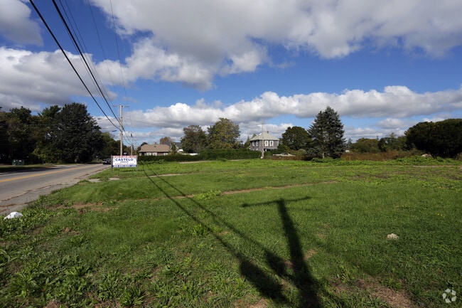

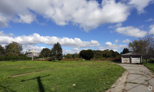
Property Detail
1138 Main St
Governmentalpublicusegeneral
BRISTOL
1
Massachusetts
B and X Area of moderate flood hazard, usually the area between the limits of the 100-year and 500-year floods.
0.25 AC
2025
Attleboro/New Bedford
2025
Boston
654100
Providence-Warwick, RI-MA
675 SF
ACUS-000007-000000-000011E
NEARBY LISTINGS FOR SALE OR LEASE
-
-
View all Acushnet listings for sale on LoopNet.com
DEMOGRAPHICS near 1138 Main St
1 mile
3 mile
5 mile
2025 Total Population
9,313
75,609
135,091
2030 Population
9,427
75,547
135,339
Pop Growth 2025-2030
+ 1.22%
(0.08%)
+ 0.18%
Average Age
42
41
41
2025 Total Households
4,124
31,688
55,610
HH Growth 2025-2030
+ 1.26%
(0.04%)
+ 0.22%
Median Household Inc
$68,240
$59,645
$64,341
Avg Household Size
2.20
2.30
2.30
2025 Avg HH Vehicles
2.00
1.00
2.00
Median Home Value
$419,661
$376,158
$400,773
Median Year Built
1948
1948
1949
Nearby Places
Map Layers
Map Styles
 Street
 Aerial
Layers
 Traffic
 Biking
Places
Listings with unknown addresses are not visible on the map
- Restaurants
- Banks
- Shops
- Fitness
- Groceries
PUBLIC TRANSPORTATION
AIRPORT
Rhode Island Tf Green International
Drive
Walk
Distance
Rhode Island Tf Green International
65 min
44.5 mi
Freight Ports
Port of New Bedford Harbor
Drive
Walk
Distance
Port of New Bedford Harbor
18 min
8.1 mi
SALE & LEASE HISTORY
LISTING DATE
SALE/LEASE

Oct 19, 2017
For Sale
Nearby Properties
Address
Land Use
TOTAL SIZE
Lot Size
Zoning
Address
Land Use
TOTAL SIZE
Lot Size
Zoning
157,346 SF
5.68 AC
RA
Address
Land Use
TOTAL SIZE
Lot Size
Zoning
54.60 AC
Address
Land Use
TOTAL SIZE
Lot Size
Zoning
105,175 SF
7.16 AC
A/R
Address
Land Use
TOTAL SIZE
Lot Size
Zoning
6.34 AC
RA
Address
Land Use
TOTAL SIZE
Lot Size
Zoning
4,041 SF
31.91 AC
Address
Land Use
TOTAL SIZE
Lot Size
Zoning
51,243 SF
8.51 AC
RA
Address
Land Use
TOTAL SIZE
Lot Size
Zoning
39,345 SF
0.79 AC
MUB
Address
Land Use
TOTAL SIZE
Lot Size
Zoning
37,824 SF
1.55 AC
MUB
Address
Land Use
TOTAL SIZE
Lot Size
Zoning
3,300 SF
4.69 AC
MUB
Address
Land Use
TOTAL SIZE
Lot Size
Zoning
52,588 SF
3.67 AC
RA
Address
Land Use
TOTAL SIZE
Lot Size
Zoning
29,900 SF
4.59 AC
MUB
Address
Land Use
TOTAL SIZE
Lot Size
Zoning
23,928 SF
54.31 AC
Address
Land Use
TOTAL SIZE
Lot Size
Zoning
1,500 SF
268.53 AC
1
Address
Land Use
TOTAL SIZE
Lot Size
Zoning
144.81 AC
Address
Land Use
TOTAL SIZE
Lot Size
Zoning
13,247 SF
0.74 AC
MUB
Address
Land Use
TOTAL SIZE
Lot Size
Zoning
55 AC
RA
Address
Land Use
TOTAL SIZE
Lot Size
Zoning
27.44 AC
RA
Address
Land Use
TOTAL SIZE
Lot Size
Zoning
4.76 AC
AR
Address
Land Use
TOTAL SIZE
Lot Size
Zoning
Address
Land Use
TOTAL SIZE
Lot Size
Zoning
2,646 SF
40 AC
G
Address
Land Use
TOTAL SIZE
Lot Size
Zoning
4.80 AC
RA
Address
Land Use
TOTAL SIZE
Lot Size
Zoning
31,800 SF
2.69 AC
Address
Land Use
TOTAL SIZE
Lot Size
Zoning
12,918 SF
1.16 AC
MUB
Address
Land Use
TOTAL SIZE
Lot Size
Zoning
138.82 AC
Address
Land Use
TOTAL SIZE
Lot Size
Zoning
58 AC
1
Address
Land Use
TOTAL SIZE
Lot Size
Zoning
16.91 AC
Address
Land Use
TOTAL SIZE
Lot Size
Zoning
7,952 SF
1.65 AC
RA
Address
Land Use
TOTAL SIZE
Lot Size
Zoning
5,554 SF
11.92 AC
MUB
Address
Land Use
TOTAL SIZE
Lot Size
Zoning
183 AC
A/R
Address
Land Use
TOTAL SIZE
Lot Size
Zoning
74.98 AC
AR
The World's #1 Commercial Real Estate Marketplace
Connect with us
© 2026 CoStar Group
The information above has been obtained from sources believed reliable. While we do not doubt its accuracy we have not verified it and make no guarantee, warranty or representation about it. It is your responsibility to independently confirm its accuracy and completeness. Any projections, opinions, assumptions, or estimates used are for example only and do not represent the current or future performance of the property. The value of this transaction to you depends on tax and other factors which should be evaluated by your tax, financial, and legal advisors. You and your advisors should conduct a careful, independent investigation of the property to determine to your satisfaction the suitability of the property for your needs.