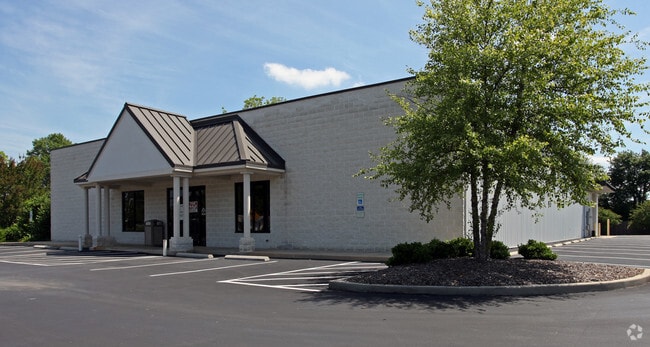
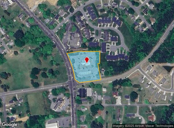
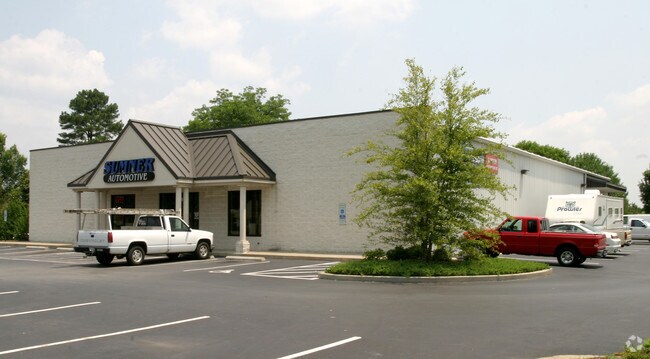
Property Record
1138 S Main St, Graham, NC 27253
NEARBY LISTINGS FOR SALE OR LEASE
Property Detail
1138 S Main St
Burlington, NC
Final Plat Ptm Lp
144385
1134 & 1138 S MAIN ST LOT 1 6/15/1947
Conveniencestore
Alamance
X
North Carolina
3710888300K
1
2025
2.13 AC
2025
S Central Alamance County
021102
Greensboro/Winston-Salem
6,375 SF
DEMOGRAPHICS near 1138 S Main St
1 Mile
3 Mile
5 Mile
2024 Total Population
4,121
31,159
76,448
2029 Population
4,423
33,745
82,810
Pop Growth 2024-2029
+ 7.33%
+ 8.30%
+ 8.32%
Average Age
44
40
40
2024 Total Households
1,768
12,771
31,063
HH Growth 2024-2029
+ 7.52%
+ 8.52%
+ 8.50%
Median Household Inc
$54,208
$53,184
$49,691
Avg Household Size
2.20
2.40
2.40
2024 Avg HH Vehicles
2.00
2.00
2.00
Median Home Value
$183,963
$177,646
$167,287
Median Year Built
1985
1981
1978
Nearby Places
Map Layers
Map Styles
 Street
 Aerial
- Restaurants
- Banks
- Shops
- Fitness
- Groceries
PUBLIC TRANSPORTATION
COMMUTER RAIL
Burlington Station (Piedmont - North Carolina by Train (NC Train))
DRIVE
WALK
Distance
Burlington Station (Piedmont - North Carolina by Train (NC Train))
9 min
4.6 mi
AIRPORT
Piedmont Triad International
DRIVE
WALK
Distance
Piedmont Triad International
50 min
34.8 mi
Raleigh-Durham International
DRIVE
WALK
Distance
Raleigh-Durham International
56 min
44.1 mi
Nearby Properties
Address
Land Use
TOTAL SIZE
Lot Size
Zoning
Address
Land Use
TOTAL SIZE
Lot Size
Zoning
2,315 SF
55.43 AC
I 1
Address
Land Use
TOTAL SIZE
Lot Size
Zoning
159,629 SF
82.81 AC
Address
Land Use
TOTAL SIZE
Lot Size
Zoning
27,803 SF
13.10 AC
B 2
Address
Land Use
TOTAL SIZE
Lot Size
Zoning
578,100 SF
55.30 AC
Address
Land Use
TOTAL SIZE
Lot Size
Zoning
48,136 SF
14.57 AC
B 2
Address
Land Use
TOTAL SIZE
Lot Size
Zoning
37,502 SF
17.48 AC
CR
Address
Land Use
TOTAL SIZE
Lot Size
Zoning
27,803 SF
11.53 AC
Address
Land Use
TOTAL SIZE
Lot Size
Zoning
12,600 SF
44.61 AC
Address
Land Use
TOTAL SIZE
Lot Size
Zoning
84,881 SF
52.87 AC
I1
Address
Land Use
TOTAL SIZE
Lot Size
Zoning
72,164 SF
73.50 AC
Address
Land Use
TOTAL SIZE
Lot Size
Zoning
10,368 SF
11.35 AC
R MF
Address
Land Use
TOTAL SIZE
Lot Size
Zoning
51,994 SF
42.20 AC
OI
Address
Land Use
TOTAL SIZE
Lot Size
Zoning
71,962 SF
5.98 AC
O I
Address
Land Use
TOTAL SIZE
Lot Size
Zoning
31,920 SF
4.59 AC
R MF
Address
Land Use
TOTAL SIZE
Lot Size
Zoning
7,192 SF
14.08 AC
RMF
Address
Land Use
TOTAL SIZE
Lot Size
Zoning
9,008 SF
6.23 AC
R MF
Address
Land Use
TOTAL SIZE
Lot Size
Zoning
20,000 SF
17.24 AC
I 1A
Address
Land Use
TOTAL SIZE
Lot Size
Zoning
159,250 SF
14 AC
I 1A
Address
Land Use
TOTAL SIZE
Lot Size
Zoning
60,458 SF
6.82 AC
I 2
Address
Land Use
TOTAL SIZE
Lot Size
Zoning
45,321 SF
31 AC
R 12
Address
Land Use
TOTAL SIZE
Lot Size
Zoning
8,312 SF
10.41 AC
Address
Land Use
TOTAL SIZE
Lot Size
Zoning
7,800 SF
5.51 AC
Address
Land Use
TOTAL SIZE
Lot Size
Zoning
43,170 SF
6.80 AC
O I
Address
Land Use
TOTAL SIZE
Lot Size
Zoning
28,908 SF
17.22 AC
I 1A
Address
Land Use
TOTAL SIZE
Lot Size
Zoning
139,530 SF
21.73 AC
Address
Land Use
TOTAL SIZE
Lot Size
Zoning
4,480 SF
11.50 AC
MF A
Address
Land Use
TOTAL SIZE
Lot Size
Zoning
27,076 SF
10 AC
R 9
Address
Land Use
TOTAL SIZE
Lot Size
Zoning
81,675 SF
21.18 AC
I 2
Address
Land Use
TOTAL SIZE
Lot Size
Zoning
20,000 SF
8.48 AC
B 2
Address
Land Use
TOTAL SIZE
Lot Size
Zoning
53,740 SF
30.43 AC
I 3
The World's #1 Commercial Real Estate Marketplace
Connect with us
© 2025 CoStar Group
The information above has been obtained from sources believed reliable. While we do not doubt its accuracy we have not verified it and make no guarantee, warranty or representation about it. It is your responsibility to independently confirm its accuracy and completeness. Any projections, opinions, assumptions, or estimates used are for example only and do not represent the current or future performance of the property. The value of this transaction to you depends on tax and other factors which should be evaluated by your tax, financial, and legal advisors. You and your advisors should conduct a careful, independent investigation of the property to determine to your satisfaction the suitability of the property for your needs.