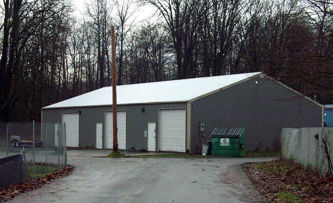
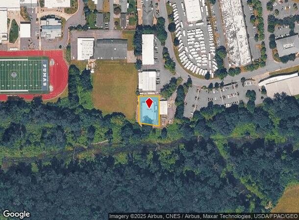
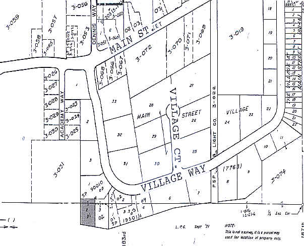
Property Record
1138 Village Way, Monroe, WA 98272
NEARBY LISTINGS FOR SALE OR LEASE
Property Detail
1138 Village Way
Seattle-Tacoma-Bellevue, WA
Main Street Village
007763-000-004-01
MAIN STREET VILLAGE BLK 000 D-01 LOT 2 OF CITY OF MON SP 90010 REC AF 9101020342 & 9012215004 BEING A PTN OF LOT 4 EXST PLAT
Industrialgeneral
Snohomish
X
Washington
53061C1376G
2
2024
0.38 AC
2025
S Snohomish County
052210
Seattle/Puget Sound
5,400 SF
DEMOGRAPHICS near 1138 Village Way
1 Mile
3 Mile
5 Mile
2024 Total Population
10,369
25,863
38,166
2029 Population
10,876
27,119
39,843
Pop Growth 2024-2029
+ 4.89%
+ 4.86%
+ 4.39%
Average Age
38
38
39
2024 Total Households
3,493
8,176
12,422
HH Growth 2024-2029
+ 5.32%
+ 5.17%
+ 4.60%
Median Household Inc
$85,894
$106,033
$116,290
Avg Household Size
2.70
2.80
2.80
2024 Avg HH Vehicles
2.00
2.00
3.00
Median Home Value
$463,999
$589,331
$674,711
Median Year Built
1993
1995
1993
Nearby Places
Map Layers
Map Styles
 Street
 Aerial
- Restaurants
- Banks
- Shops
- Fitness
- Groceries
PUBLIC TRANSPORTATION
AIRPORT
Seattle Paine Field International
DRIVE
WALK
Distance
Seattle Paine Field International
37 min
24.3 mi
Seattle-Tacoma International
DRIVE
WALK
Distance
Seattle-Tacoma International
57 min
40.2 mi
Freight Ports
Port of Everett
DRIVE
WALK
Distance
Port of Everett
27 min
16.7 mi
Nearby Properties
Address
Land Use
TOTAL SIZE
Lot Size
Zoning
Address
Land Use
TOTAL SIZE
Lot Size
Zoning
595.90 AC
PS
Address
Land Use
TOTAL SIZE
Lot Size
Zoning
41,232 SF
88.74 AC
GC
Address
Land Use
TOTAL SIZE
Lot Size
Zoning
381,991 SF
10.41 AC
MR6000
Address
Land Use
TOTAL SIZE
Lot Size
Zoning
263,812 SF
12.64 AC
LI
Address
Land Use
TOTAL SIZE
Lot Size
Zoning
142,629 SF
8.76 AC
DC
Address
Land Use
TOTAL SIZE
Lot Size
Zoning
9.80 AC
PO
Address
Land Use
TOTAL SIZE
Lot Size
Zoning
79.16 AC
PS
Address
Land Use
TOTAL SIZE
Lot Size
Zoning
108,120 SF
10.33 AC
MR6000
Address
Land Use
TOTAL SIZE
Lot Size
Zoning
172,878 SF
15.34 AC
GC
Address
Land Use
TOTAL SIZE
Lot Size
Zoning
156,220 SF
17.30 AC
GC
Address
Land Use
TOTAL SIZE
Lot Size
Zoning
153,578 SF
5.56 AC
LI
Address
Land Use
TOTAL SIZE
Lot Size
Zoning
47,357 SF
6.82 AC
LI
Address
Land Use
TOTAL SIZE
Lot Size
Zoning
3,720 SF
46.72 AC
GC
Address
Land Use
TOTAL SIZE
Lot Size
Zoning
139,412 SF
7.08 AC
GC
Address
Land Use
TOTAL SIZE
Lot Size
Zoning
95,685 SF
4.92 AC
LI
Address
Land Use
TOTAL SIZE
Lot Size
Zoning
85,045 SF
2.87 AC
UR6000
Address
Land Use
TOTAL SIZE
Lot Size
Zoning
41,896 SF
5 AC
GC
Address
Land Use
TOTAL SIZE
Lot Size
Zoning
49,401 SF
1.69 AC
PO
Address
Land Use
TOTAL SIZE
Lot Size
Zoning
44,337 SF
4.81 AC
LI
Address
Land Use
TOTAL SIZE
Lot Size
Zoning
76,010 SF
3.59 AC
LI
Address
Land Use
TOTAL SIZE
Lot Size
Zoning
75,922 SF
3.31 AC
LI
Address
Land Use
TOTAL SIZE
Lot Size
Zoning
12.07 AC
PS
Address
Land Use
TOTAL SIZE
Lot Size
Zoning
61,900 SF
4.06 AC
GC
Address
Land Use
TOTAL SIZE
Lot Size
Zoning
65,999 SF
3.55 AC
LI
Address
Land Use
TOTAL SIZE
Lot Size
Zoning
80,800 SF
4.26 AC
LI
Address
Land Use
TOTAL SIZE
Lot Size
Zoning
45,434 SF
2.36 AC
MUC
Address
Land Use
TOTAL SIZE
Lot Size
Zoning
45,504 SF
2.67 AC
SC
Address
Land Use
TOTAL SIZE
Lot Size
Zoning
67,200 SF
3.78 AC
LI
Address
Land Use
TOTAL SIZE
Lot Size
Zoning
38,040 SF
1.74 AC
GC
Address
Land Use
TOTAL SIZE
Lot Size
Zoning
62,562 SF
3.14 AC
LI
The World's #1 Commercial Real Estate Marketplace
Connect with us
© 2025 CoStar Group
The information above has been obtained from sources believed reliable. While we do not doubt its accuracy we have not verified it and make no guarantee, warranty or representation about it. It is your responsibility to independently confirm its accuracy and completeness. Any projections, opinions, assumptions, or estimates used are for example only and do not represent the current or future performance of the property. The value of this transaction to you depends on tax and other factors which should be evaluated by your tax, financial, and legal advisors. You and your advisors should conduct a careful, independent investigation of the property to determine to your satisfaction the suitability of the property for your needs.