Property Record
11385 Sebring Dr, Cincinnati, OH 45240


Save to a Folder
{{folder.Name}}
{{folder.ListingIds.length}} Properties
{{folder.ListingIds.length}} Property
Create a New Folder
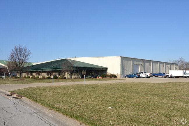
Property Detail
11385 Sebring Dr
Cincinnati, OH-KY-IN
SEBRING DR 154.38XFT IRR LT12 CROSSWAYS INDUSTRIALPARK PT 1
591-0025-0225
Hamilton
Lightindustrial
Ohio
B and X Area of moderate flood hazard, usually the area between the limits of the 100-year and 500-year floods.
12
2025
2.48 AC
2025
West
021572
Cincinnati/Dayton
33,741 SF
NEARBY LISTINGS FOR SALE OR LEASE
-
-
View all Cincinnati listings for sale on LoopNet.com
DEMOGRAPHICS near 11385 Sebring Dr
1 mile
3 mile
5 mile
2025 Total Population
10,534
61,322
162,019
2030 Population
10,613
61,729
163,803
Pop Growth 2025-2030
+ 0.75%
+ 0.66%
+ 1.10%
Average Age
38
40
41
2025 Total Households
4,014
22,952
64,406
HH Growth 2025-2030
+ 0.82%
+ 0.63%
+ 1.14%
Median Household Inc
$59,555
$73,380
$69,316
Avg Household Size
2.50
2.60
2.40
2025 Avg HH Vehicles
2.00
2.00
2.00
Median Home Value
$183,352
$212,102
$201,186
Median Year Built
1975
1973
1971
Nearby Places
Map Layers
Map Styles
 Street
 Aerial
Layers
 Traffic
 Biking
Places
Listings with unknown addresses are not visible on the map
- Restaurants
- Banks
- Shops
- Fitness
- Groceries
PUBLIC TRANSPORTATION
AIRPORT
Cincinnati/Northern Kentucky International
Drive
Walk
Distance
Cincinnati/Northern Kentucky International
50 min
31.0 mi
Nearby Properties
Address
Land Use
TOTAL SIZE
Lot Size
Zoning
Address
Land Use
TOTAL SIZE
Lot Size
Zoning
38,880 SF
20.93 AC
Address
Land Use
TOTAL SIZE
Lot Size
Zoning
34.60 AC
Address
Land Use
TOTAL SIZE
Lot Size
Zoning
87,612 SF
16.29 AC
R3
Address
Land Use
TOTAL SIZE
Lot Size
Zoning
1,363,493 SF
75.28 AC
Address
Land Use
TOTAL SIZE
Lot Size
Zoning
52,548 SF
39.18 AC
Address
Land Use
TOTAL SIZE
Lot Size
Zoning
44.58 AC
Address
Land Use
TOTAL SIZE
Lot Size
Zoning
29.78 AC
Address
Land Use
TOTAL SIZE
Lot Size
Zoning
4,849 SF
19.98 AC
Address
Land Use
TOTAL SIZE
Lot Size
Zoning
20.68 AC
Address
Land Use
TOTAL SIZE
Lot Size
Zoning
279,161 SF
28.02 AC
Address
Land Use
TOTAL SIZE
Lot Size
Zoning
3,538 SF
23.40 AC
Address
Land Use
TOTAL SIZE
Lot Size
Zoning
59,744 SF
31.77 AC
Address
Land Use
TOTAL SIZE
Lot Size
Zoning
5,073 SF
14.07 AC
Address
Land Use
TOTAL SIZE
Lot Size
Zoning
103.18 AC
R1A
Address
Land Use
TOTAL SIZE
Lot Size
Zoning
52,138 SF
17.43 AC
Address
Land Use
TOTAL SIZE
Lot Size
Zoning
2,400 SF
0.35 AC
R1
Address
Land Use
TOTAL SIZE
Lot Size
Zoning
9,982 SF
36.33 AC
Address
Land Use
TOTAL SIZE
Lot Size
Zoning
Address
Land Use
TOTAL SIZE
Lot Size
Zoning
Address
Land Use
TOTAL SIZE
Lot Size
Zoning
166,800 SF
15.25 AC
Address
Land Use
TOTAL SIZE
Lot Size
Zoning
3,996 SF
14.27 AC
Address
Land Use
TOTAL SIZE
Lot Size
Zoning
125,384 SF
13.68 AC
Address
Land Use
TOTAL SIZE
Lot Size
Zoning
3,000 SF
29.22 AC
Address
Land Use
TOTAL SIZE
Lot Size
Zoning
11,316 SF
8.43 AC
RPUD
Address
Land Use
TOTAL SIZE
Lot Size
Zoning
14.27 AC
Address
Land Use
TOTAL SIZE
Lot Size
Zoning
229,447 SF
26.06 AC
Address
Land Use
TOTAL SIZE
Lot Size
Zoning
Address
Land Use
TOTAL SIZE
Lot Size
Zoning
15.25 AC
Address
Land Use
TOTAL SIZE
Lot Size
Zoning
23.61 AC
RPUD
Address
Land Use
TOTAL SIZE
Lot Size
Zoning
360 SF
362.04 AC
R1A
The World's #1 Commercial Real Estate Marketplace
Connect with us
© 2026 CoStar Group
The information above has been obtained from sources believed reliable. While we do not doubt its accuracy we have not verified it and make no guarantee, warranty or representation about it. It is your responsibility to independently confirm its accuracy and completeness. Any projections, opinions, assumptions, or estimates used are for example only and do not represent the current or future performance of the property. The value of this transaction to you depends on tax and other factors which should be evaluated by your tax, financial, and legal advisors. You and your advisors should conduct a careful, independent investigation of the property to determine to your satisfaction the suitability of the property for your needs.