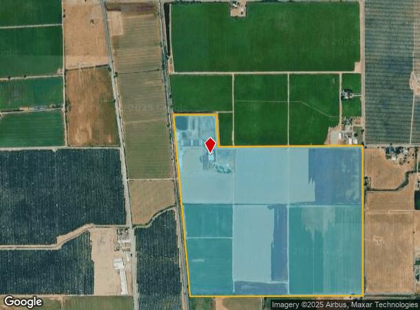
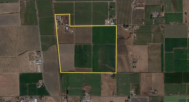
Property Record
11391 Franklin Blvd, Elk Grove, CA 95757

This Property Is For Sale
NEARBY LISTINGS FOR SALE OR LEASE
Property Detail
11391 Franklin Blvd
132-0251-007
POR. OF SECS. 20,21,28 &29, T6N,R5E, MDB&M DESC. AS BEG.AT THE CENTER OF SD. SEC. 28.TH. FR. SD. P.O.B. N. ALG. THE C/LOF SD.
Pasture
Sacramento
AE
California
06067C0450H
200.30 AC
2024
Outer Sacramento County
2025
Sacramento
009653
Sacramento--Roseville--Arden-Arcade, CA
DEMOGRAPHICS near 11391 Franklin Blvd
1 Mile
3 Mile
5 Mile
2024 Total Population
112
15,386
74,746
2029 Population
106
15,560
75,800
Pop Growth 2024-2029
(5.36%)
+ 1.13%
+ 1.41%
Average Age
41
37
38
2024 Total Households
41
4,036
22,447
HH Growth 2024-2029
(4.88%)
+ 1.36%
+ 1.42%
Median Household Inc
$89,843
$118,063
$118,692
Avg Household Size
2.70
3.50
3.20
2024 Avg HH Vehicles
3.00
3.00
2.00
Median Home Value
$712,500
$655,581
$632,899
Median Year Built
1976
2006
2005
Nearby Places
Map Layers
Map Styles
 Street
 Aerial
- Restaurants
- Banks
- Shops
- Fitness
- Groceries
PUBLIC TRANSPORTATION
AIRPORT
Sacramento International
DRIVE
WALK
Distance
Sacramento International
41 min
29.3 mi
Freight Ports
Port of Stockton
DRIVE
WALK
Distance
Port of Stockton
41 min
30.4 mi
Nearby Properties
Address
Land Use
TOTAL SIZE
Lot Size
Zoning
Address
Land Use
TOTAL SIZE
Lot Size
Zoning
192,518 SF
8.97 AC
RD-20
Address
Land Use
TOTAL SIZE
Lot Size
Zoning
221,954 SF
7.71 AC
RD-15
Address
Land Use
TOTAL SIZE
Lot Size
Zoning
68,217 SF
8.95 AC
RD-20
Address
Land Use
TOTAL SIZE
Lot Size
Zoning
25.22 AC
SPASEPA
Address
Land Use
TOTAL SIZE
Lot Size
Zoning
Address
Land Use
TOTAL SIZE
Lot Size
Zoning
15,354 SF
3 AC
A-2
Address
Land Use
TOTAL SIZE
Lot Size
Zoning
511.46 AC
AG-80
Address
Land Use
TOTAL SIZE
Lot Size
Zoning
26.72 AC
O RD-4 PR
Address
Land Use
TOTAL SIZE
Lot Size
Zoning
24.02 AC
RD-4 RD-7
Address
Land Use
TOTAL SIZE
Lot Size
Zoning
936 SF
20.53 AC
RD-5 RD-4
Address
Land Use
TOTAL SIZE
Lot Size
Zoning
128.65 AC
AG-80
Address
Land Use
TOTAL SIZE
Lot Size
Zoning
157.57 AC
AG-80
Address
Land Use
TOTAL SIZE
Lot Size
Zoning
6.44 AC
RD-7
Address
Land Use
TOTAL SIZE
Lot Size
Zoning
4,334 SF
160 AC
AG-80
Address
Land Use
TOTAL SIZE
Lot Size
Zoning
12.48 AC
SPASEP
Address
Land Use
TOTAL SIZE
Lot Size
Zoning
1,605 SF
8.12 AC
SPASEPA
Address
Land Use
TOTAL SIZE
Lot Size
Zoning
1,432 SF
158.18 AC
AG-80
Address
Land Use
TOTAL SIZE
Lot Size
Zoning
79.11 AC
AG-80
Address
Land Use
TOTAL SIZE
Lot Size
Zoning
Address
Land Use
TOTAL SIZE
Lot Size
Zoning
16,844 SF
72.30 AC
AG-80
Address
Land Use
TOTAL SIZE
Lot Size
Zoning
16,093 SF
10.90 AC
A-5
Address
Land Use
TOTAL SIZE
Lot Size
Zoning
70.35 AC
AG-80
Address
Land Use
TOTAL SIZE
Lot Size
Zoning
80 AC
AG-80
Address
Land Use
TOTAL SIZE
Lot Size
Zoning
986 SF
80 AC
AG-80
Address
Land Use
TOTAL SIZE
Lot Size
Zoning
1,450 SF
79.67 AC
AG-80
Address
Land Use
TOTAL SIZE
Lot Size
Zoning
126.45 AC
AG-80
Address
Land Use
TOTAL SIZE
Lot Size
Zoning
16,844 SF
73.56 AC
AG-80
Address
Land Use
TOTAL SIZE
Lot Size
Zoning
2,274 SF
50 AC
AG-80
Address
Land Use
TOTAL SIZE
Lot Size
Zoning
1,410 SF
36.85 AC
AG-20
The World's #1 Commercial Real Estate Marketplace
Connect with us
© 2026 CoStar Group
The information above has been obtained from sources believed reliable. While we do not doubt its accuracy we have not verified it and make no guarantee, warranty or representation about it. It is your responsibility to independently confirm its accuracy and completeness. Any projections, opinions, assumptions, or estimates used are for example only and do not represent the current or future performance of the property. The value of this transaction to you depends on tax and other factors which should be evaluated by your tax, financial, and legal advisors. You and your advisors should conduct a careful, independent investigation of the property to determine to your satisfaction the suitability of the property for your needs.