No Photo
Property Record
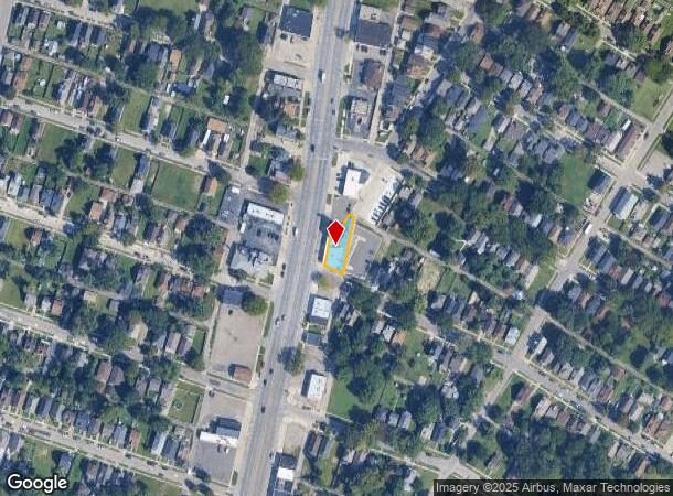
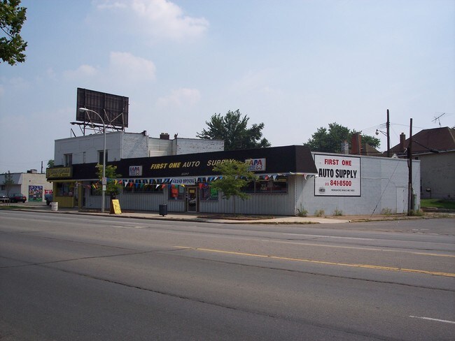
11397 W Jefferson Ave, River Rouge, MI 48218

NEARBY LISTINGS FOR SALE OR LEASE
Property Detail
11397 W Jefferson Ave
Detroit-Warren-Dearborn, MI
S Highland
50-004-18-0001-001
497G1A TO 497G4A LOTS 1 TO 4 COMBINED EXC THE W PT THEREOF MEASURING 53.23 FT ON THE S W LINE AND 51.56 FT ON THE MOST WLY N E LINE OF SAID COM- BINED PARCEL ROEHRIG AND DEBO'S HIGHLAND SUB PC 497,525 L25 P39 WCR
Restaurantdrivein
Wayne
X
Michigan
26163C0269F
1-4
2024
0.14 AC
2025
Downriver North
579200
Detroit
7,040 SF
DEMOGRAPHICS near 11397 W Jefferson Ave
1 Mile
3 Mile
5 Mile
2024 Total Population
13,370
66,764
195,149
2029 Population
13,261
64,779
188,259
Pop Growth 2024-2029
(0.82%)
(2.97%)
(3.53%)
Average Age
37
38
38
2024 Total Households
5,085
25,197
73,044
HH Growth 2024-2029
(0.92%)
(2.98%)
(3.56%)
Median Household Inc
$33,989
$43,874
$51,067
Avg Household Size
2.60
2.60
2.60
2024 Avg HH Vehicles
1.00
1.00
2.00
Median Home Value
$60,892
$89,713
$130,639
Median Year Built
1949
1952
1951
Nearby Places
Map Layers
Map Styles
 Street
 Aerial
- Restaurants
- Banks
- Shops
- Fitness
- Groceries
PUBLIC TRANSPORTATION
COMMUTER RAIL
DRIVE
WALK
Distance
19 min
7.9 mi
AIRPORT
Detroit Metro Wayne County
DRIVE
WALK
Distance
Detroit Metro Wayne County
32 min
17.5 mi
Windsor International
DRIVE
WALK
Distance
Windsor International
37 min
18.2 mi
Freight Ports
DRIVE
WALK
Distance
71 min
55.1 mi
Nearby Properties
Address
Land Use
TOTAL SIZE
Lot Size
Zoning
Address
Land Use
TOTAL SIZE
Lot Size
Zoning
1,025,154 SF
233.15 AC
Address
Land Use
TOTAL SIZE
Lot Size
Zoning
7,320 SF
226.49 AC
Address
Land Use
TOTAL SIZE
Lot Size
Zoning
196,801 SF
38.32 AC
M5
Address
Land Use
TOTAL SIZE
Lot Size
Zoning
193,155 SF
8.68 AC
R1 1 FA
Address
Land Use
TOTAL SIZE
Lot Size
Zoning
145,572 SF
58.41 AC
M4
Address
Land Use
TOTAL SIZE
Lot Size
Zoning
314,003 SF
26.32 AC
B6
Address
Land Use
TOTAL SIZE
Lot Size
Zoning
76,350 SF
0.69 AC
Address
Land Use
TOTAL SIZE
Lot Size
Zoning
79.03 AC
M2 HEAV
Address
Land Use
TOTAL SIZE
Lot Size
Zoning
52,964 SF
10.89 AC
Address
Land Use
TOTAL SIZE
Lot Size
Zoning
351,906 SF
42.21 AC
M4
Address
Land Use
TOTAL SIZE
Lot Size
Zoning
897,317 SF
34.53 AC
ID
Address
Land Use
TOTAL SIZE
Lot Size
Zoning
660 SF
41.97 AC
R1 1 FA
Address
Land Use
TOTAL SIZE
Lot Size
Zoning
105,920 SF
12.46 AC
Address
Land Use
TOTAL SIZE
Lot Size
Zoning
45,400 SF
R1 1 FA
Address
Land Use
TOTAL SIZE
Lot Size
Zoning
32,245 SF
23.27 AC
M5
Address
Land Use
TOTAL SIZE
Lot Size
Zoning
105,503 SF
19.83 AC
Address
Land Use
TOTAL SIZE
Lot Size
Zoning
95,679 SF
27.44 AC
M4
Address
Land Use
TOTAL SIZE
Lot Size
Zoning
77,026 SF
9.64 AC
R1 1 FA
Address
Land Use
TOTAL SIZE
Lot Size
Zoning
106.97 AC
M2 HEAV
Address
Land Use
TOTAL SIZE
Lot Size
Zoning
47,778 SF
27.12 AC
R1 1 FA
Address
Land Use
TOTAL SIZE
Lot Size
Zoning
3,430 SF
79.54 AC
M2 HEAV
Address
Land Use
TOTAL SIZE
Lot Size
Zoning
228,000 SF
12.70 AC
Address
Land Use
TOTAL SIZE
Lot Size
Zoning
414,868 SF
26.36 AC
R1 1 FA
Address
Land Use
TOTAL SIZE
Lot Size
Zoning
8,774 SF
29.39 AC
R1 1 FA
Address
Land Use
TOTAL SIZE
Lot Size
Zoning
108,000 SF
7.46 AC
Address
Land Use
TOTAL SIZE
Lot Size
Zoning
292,797 SF
9.31 AC
Address
Land Use
TOTAL SIZE
Lot Size
Zoning
77,520 SF
6.52 AC
IC
Address
Land Use
TOTAL SIZE
Lot Size
Zoning
182,640 SF
13.98 AC
Address
Land Use
TOTAL SIZE
Lot Size
Zoning
282,489 SF
15.96 AC
Address
Land Use
TOTAL SIZE
Lot Size
Zoning
178,795 SF
5.66 AC
R1 1 FA
The World's #1 Commercial Real Estate Marketplace
Connect with us
© 2025 CoStar Group
The information above has been obtained from sources believed reliable. While we do not doubt its accuracy we have not verified it and make no guarantee, warranty or representation about it. It is your responsibility to independently confirm its accuracy and completeness. Any projections, opinions, assumptions, or estimates used are for example only and do not represent the current or future performance of the property. The value of this transaction to you depends on tax and other factors which should be evaluated by your tax, financial, and legal advisors. You and your advisors should conduct a careful, independent investigation of the property to determine to your satisfaction the suitability of the property for your needs.