Property Record
114 E 11Th St, Perris, CA 92570
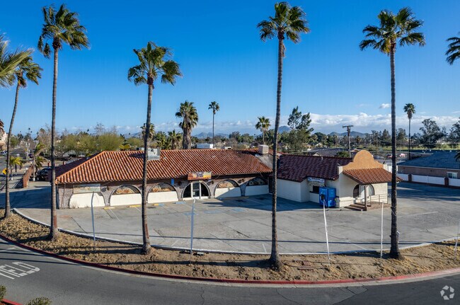

This Property Is For Sale
Property Detail
114 E 11Th St
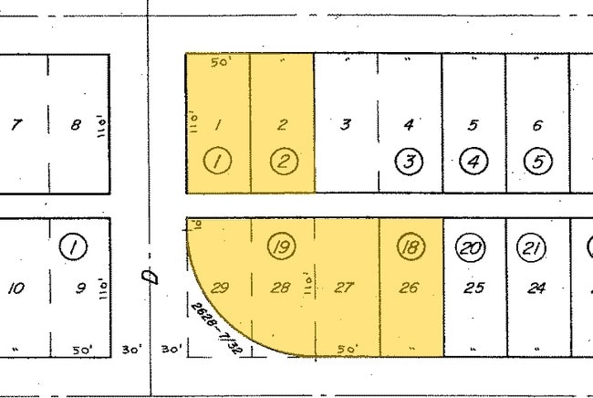
313-272-019
LOTS 27, 28 & 29 BLK 14 MB 009/398 SD BLETHENS ADD TO PERRIS ALSO SEE MB 10/454 SD
Storebuilding
RIVERSIDE
M1
California
B and X Area of moderate flood hazard, usually the area between the limits of the 100-year and 500-year floods.
29
2024
0.33 AC
2025
Moreno Valley/Perris
042903
Inland Empire (California)
3,280 SF
Riverside-San Bernardino-Ontario, CA
NEARBY LISTINGS FOR SALE OR LEASE
DEMOGRAPHICS near 114 E 11Th St
1 mile
3 mile
5 mile
2024 Total Population
10,823
60,962
118,123
2029 Population
11,233
62,698
121,416
Pop Growth 2024-2029
+ 3.79%
+ 2.85%
+ 2.79%
Average Age
33
33
36
2024 Total Households
2,810
14,747
31,348
HH Growth 2024-2029
+ 3.74%
+ 2.75%
+ 2.62%
Median Household Inc
$68,936
$77,592
$77,814
Avg Household Size
3.80
4.00
3.60
2024 Avg HH Vehicles
2.00
2.00
2.00
Median Home Value
$435,078
$449,452
$451,370
Median Year Built
1985
1992
1992
Nearby Places
Map Layers
Map Styles
 Street
 Aerial
Transit
 Traffic
 Biking
Places
Listings with unknown addresses are not visible on the map
- Restaurants
- Banks
- Shops
- Fitness
- Groceries
PUBLIC TRANSPORTATION
COMMUTER RAIL
Drive
Walk
Distance
2 min
14 min
0.7 mi
Drive
Walk
Distance
3 min
1.6 mi
AIRPORT
Ontario International
Drive
Walk
Distance
Ontario International
43 min
34.6 mi
Nearby Properties
Address
Land Use
TOTAL SIZE
Lot Size
Zoning
Address
Land Use
TOTAL SIZE
Lot Size
Zoning
325,560 SF
16.65 AC
Address
Land Use
TOTAL SIZE
Lot Size
Zoning
28.13 AC
RR
Address
Land Use
TOTAL SIZE
Lot Size
Zoning
197,865 SF
10.74 AC
Address
Land Use
TOTAL SIZE
Lot Size
Zoning
57,600 SF
51.69 AC
Address
Land Use
TOTAL SIZE
Lot Size
Zoning
6.99 AC
MIX
Address
Land Use
TOTAL SIZE
Lot Size
Zoning
187,889 SF
20.64 AC
Address
Land Use
TOTAL SIZE
Lot Size
Zoning
32,709 SF
4.61 AC
C2
Address
Land Use
TOTAL SIZE
Lot Size
Zoning
89,409 SF
6.18 AC
Address
Land Use
TOTAL SIZE
Lot Size
Zoning
207,130 SF
16.15 AC
Address
Land Use
TOTAL SIZE
Lot Size
Zoning
22,119 SF
4.59 AC
R3
Address
Land Use
TOTAL SIZE
Lot Size
Zoning
75,109 SF
9.39 AC
Address
Land Use
TOTAL SIZE
Lot Size
Zoning
1,080 SF
9.53 AC
A02
Address
Land Use
TOTAL SIZE
Lot Size
Zoning
122,824 SF
5.18 AC
CC
Address
Land Use
TOTAL SIZE
Lot Size
Zoning
50,000 SF
5.36 AC
CC
Address
Land Use
TOTAL SIZE
Lot Size
Zoning
10.85 AC
MH
Address
Land Use
TOTAL SIZE
Lot Size
Zoning
47,440 SF
5.32 AC
C2
Address
Land Use
TOTAL SIZE
Lot Size
Zoning
1,018,178 SF
57.91 AC
Address
Land Use
TOTAL SIZE
Lot Size
Zoning
3,750 SF
37.79 AC
GI
Address
Land Use
TOTAL SIZE
Lot Size
Zoning
201,496 SF
13.35 AC
LI
Address
Land Use
TOTAL SIZE
Lot Size
Zoning
7,250 SF
2.35 AC
Address
Land Use
TOTAL SIZE
Lot Size
Zoning
35,600 SF
3.19 AC
Address
Land Use
TOTAL SIZE
Lot Size
Zoning
13,489 SF
6.18 AC
R3
The World's #1 Commercial Real Estate Marketplace
Connect with us
© 2026 CoStar Group
The information above has been obtained from sources believed reliable. While we do not doubt its accuracy we have not verified it and make no guarantee, warranty or representation about it. It is your responsibility to independently confirm its accuracy and completeness. Any projections, opinions, assumptions, or estimates used are for example only and do not represent the current or future performance of the property. The value of this transaction to you depends on tax and other factors which should be evaluated by your tax, financial, and legal advisors. You and your advisors should conduct a careful, independent investigation of the property to determine to your satisfaction the suitability of the property for your needs.