Property Record
114 Lamplight Cir, Summerville, SC 29483


NEARBY LISTINGS FOR SALE OR LEASE
-
-
View all Summerville listings for sale on LoopNet.com
Property Detail
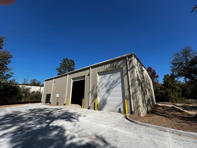
114 Lamplight Cir
Charleston-North Charleston, SC
Plat Showing Tms 121 00 00 263 A 7 24 Ac
121-00-00-320
TRACT B
Vacantlandnec
Dorchester
AE
South Carolina
45015C0535E
1.25 AC
2025
Dorchester County
2025
Charleston/N Charleston
010501
DEMOGRAPHICS near 114 Lamplight Cir
1 Mile
3 Mile
5 Mile
2024 Total Population
1,498
12,622
36,904
2029 Population
1,627
13,767
40,447
Pop Growth 2024-2029
+ 8.61%
+ 9.07%
+ 9.60%
Average Age
35
37
38
2024 Total Households
481
4,043
12,552
HH Growth 2024-2029
+ 8.73%
+ 9.03%
+ 9.52%
Median Household Inc
$89,833
$82,380
$77,227
Avg Household Size
3.00
2.90
2.80
2024 Avg HH Vehicles
2.00
2.00
2.00
Median Home Value
$263,654
$276,624
$280,781
Median Year Built
2010
2007
2004
Nearby Places
Map Layers
Map Styles
 Street
 Aerial
- Restaurants
- Banks
- Shops
- Fitness
- Groceries
PUBLIC TRANSPORTATION
AIRPORT
Charleston AFB/International
DRIVE
WALK
Distance
Charleston AFB/International
33 min
19.6 mi
SALE & LEASE HISTORY
LISTING DATE
SALE/LEASE

Nov 08, 2023
For Lease
Jun 13, 2024
For Sale
Nearby Properties
Address
Land Use
TOTAL SIZE
Lot Size
Zoning
Address
Land Use
TOTAL SIZE
Lot Size
Zoning
605.46 AC
R-2_DC
Address
Land Use
TOTAL SIZE
Lot Size
Zoning
621,920 SF
87.29 AC
I_DC
Address
Land Use
TOTAL SIZE
Lot Size
Zoning
528,320 SF
38.11 AC
I_DC
Address
Land Use
TOTAL SIZE
Lot Size
Zoning
11,847 SF
11.87 AC
BERKELEY C
Address
Land Use
TOTAL SIZE
Lot Size
Zoning
10,000 SF
143.22 AC
TN_RI
Address
Land Use
TOTAL SIZE
Lot Size
Zoning
158,340 SF
28.93 AC
I_DC
Address
Land Use
TOTAL SIZE
Lot Size
Zoning
80,465 SF
19.07 AC
I_DC
Address
Land Use
TOTAL SIZE
Lot Size
Zoning
395,074 SF
21.33 AC
I_DC
Address
Land Use
TOTAL SIZE
Lot Size
Zoning
161,548 SF
16.56 AC
I_DC
Address
Land Use
TOTAL SIZE
Lot Size
Zoning
121,500 SF
40.85 AC
I_DC
Address
Land Use
TOTAL SIZE
Lot Size
Zoning
281,313 SF
17.55 AC
I_DC
Address
Land Use
TOTAL SIZE
Lot Size
Zoning
110,000 SF
7.76 AC
I_DC
Address
Land Use
TOTAL SIZE
Lot Size
Zoning
2,400 SF
24.57 AC
I_DC
Address
Land Use
TOTAL SIZE
Lot Size
Zoning
35,000 SF
4.15 AC
CG_DC
Address
Land Use
TOTAL SIZE
Lot Size
Zoning
536.07 AC
AR_DC
Address
Land Use
TOTAL SIZE
Lot Size
Zoning
3,898 SF
28.27 AC
OSR
Address
Land Use
TOTAL SIZE
Lot Size
Zoning
1,262.60 AC
AR_DC
Address
Land Use
TOTAL SIZE
Lot Size
Zoning
80 AC
CG_DC
Address
Land Use
TOTAL SIZE
Lot Size
Zoning
128.11 AC
MUC_DC
Address
Land Use
TOTAL SIZE
Lot Size
Zoning
154.25 AC
AR_DC
Address
Land Use
TOTAL SIZE
Lot Size
Zoning
108,240 SF
9.29 AC
I_DC
Address
Land Use
TOTAL SIZE
Lot Size
Zoning
0.11 AC
TC
Address
Land Use
TOTAL SIZE
Lot Size
Zoning
66.44 AC
MUC_DC
Address
Land Use
TOTAL SIZE
Lot Size
Zoning
840 SF
3.50 AC
BERKELEY C
Address
Land Use
TOTAL SIZE
Lot Size
Zoning
61.87 AC
R-1_DC
Address
Land Use
TOTAL SIZE
Lot Size
Zoning
27.19 AC
I_DC
Address
Land Use
TOTAL SIZE
Lot Size
Zoning
27.04 AC
I_DC
Address
Land Use
TOTAL SIZE
Lot Size
Zoning
67.30 AC
CLI_DC
Address
Land Use
TOTAL SIZE
Lot Size
Zoning
195,766 SF
11.76 AC
CLI_DC
The World's #1 Commercial Real Estate Marketplace
Connect with us
© 2026 CoStar Group
The information above has been obtained from sources believed reliable. While we do not doubt its accuracy we have not verified it and make no guarantee, warranty or representation about it. It is your responsibility to independently confirm its accuracy and completeness. Any projections, opinions, assumptions, or estimates used are for example only and do not represent the current or future performance of the property. The value of this transaction to you depends on tax and other factors which should be evaluated by your tax, financial, and legal advisors. You and your advisors should conduct a careful, independent investigation of the property to determine to your satisfaction the suitability of the property for your needs.