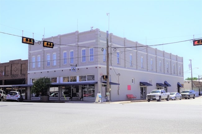
Property Record
103 W 2Nd St, Elgin, TX 78621

Property Detail
103 W 2Nd St
Austin-Round Rock-San Marcos, TX
ELGIN CITY, BLOCK 38, LOT 5
14100
Bastrop
Commercialnec
Texas
B and X Area of moderate flood hazard, usually the area between the limits of the 100-year and 500-year floods.
5
2024
0.13 AC
2025
Bastrop County
950202
Austin
11,500 SF
NEARBY LISTINGS FOR SALE OR LEASE
-
-
View all Elgin listings for sale on LoopNet.com
DEMOGRAPHICS near 103 W 2Nd St
1 mile
3 mile
5 mile
2024 Total Population
6,725
14,751
23,167
2029 Population
8,441
18,235
28,063
Pop Growth 2024-2029
+ 25.52%
+ 23.62%
+ 21.13%
Average Age
37
37
37
2024 Total Households
2,302
5,002
7,755
HH Growth 2024-2029
+ 26.72%
+ 24.89%
+ 22.50%
Median Household Inc
$75,647
$76,401
$87,723
Avg Household Size
2.80
2.90
2.90
2024 Avg HH Vehicles
2.00
2.00
2.00
Median Home Value
$247,088
$240,778
$259,078
Median Year Built
1981
1987
1996
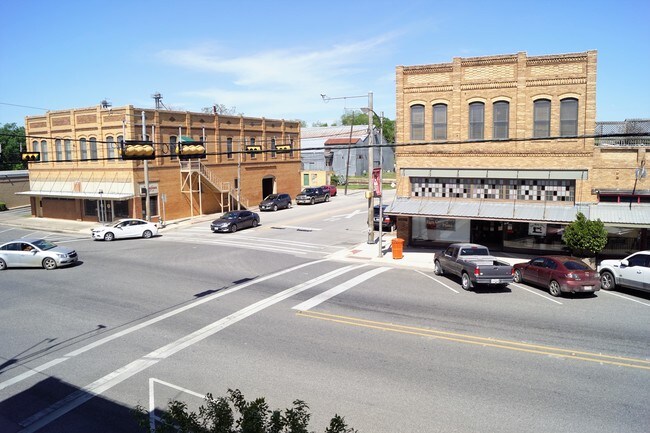
Nearby Places
Map Layers
Map Styles
 Street
 Aerial
Transit
 Traffic
 Biking
Places
Listings with unknown addresses are not visible on the map
- Restaurants
- Banks
- Shops
- Fitness
- Groceries
PUBLIC TRANSPORTATION
AIRPORT
Austin-Bergstrom International
Drive
Walk
Distance
Austin-Bergstrom International
42 min
29.4 mi
SALE & LEASE HISTORY
LISTING DATE
SALE/LEASE

Apr 23, 2019
For Sale
Nearby Properties
Address
Land Use
TOTAL SIZE
Lot Size
Zoning
Address
Land Use
TOTAL SIZE
Lot Size
Zoning
343,452 SF
91.16 AC
Address
Land Use
TOTAL SIZE
Lot Size
Zoning
125,720 SF
74.99 AC
Address
Land Use
TOTAL SIZE
Lot Size
Zoning
85,780 SF
12.92 AC
Address
Land Use
TOTAL SIZE
Lot Size
Zoning
63,700 SF
14.77 AC
Address
Land Use
TOTAL SIZE
Lot Size
Zoning
155,983 SF
17.99 AC
Address
Land Use
TOTAL SIZE
Lot Size
Zoning
139,989 SF
5.73 AC
Address
Land Use
TOTAL SIZE
Lot Size
Zoning
108,900 SF
27.89 AC
Address
Land Use
TOTAL SIZE
Lot Size
Zoning
97.60 AC
Address
Land Use
TOTAL SIZE
Lot Size
Zoning
56,011 SF
2.46 AC
Address
Land Use
TOTAL SIZE
Lot Size
Zoning
83,989 SF
11.77 AC
Address
Land Use
TOTAL SIZE
Lot Size
Zoning
72,600 SF
19.72 AC
Address
Land Use
TOTAL SIZE
Lot Size
Zoning
74,820 SF
9.34 AC
Address
Land Use
TOTAL SIZE
Lot Size
Zoning
63,520 SF
5.49 AC
Address
Land Use
TOTAL SIZE
Lot Size
Zoning
136.49 AC
Address
Land Use
TOTAL SIZE
Lot Size
Zoning
45,180 SF
5.35 AC
Address
Land Use
TOTAL SIZE
Lot Size
Zoning
36,451 SF
1.23 AC
Address
Land Use
TOTAL SIZE
Lot Size
Zoning
38,336 SF
4.02 AC
Address
Land Use
TOTAL SIZE
Lot Size
Zoning
5,385 SF
46.20 AC
Address
Land Use
TOTAL SIZE
Lot Size
Zoning
18,697 SF
0.79 AC
Address
Land Use
TOTAL SIZE
Lot Size
Zoning
19,637 SF
2.71 AC
Address
Land Use
TOTAL SIZE
Lot Size
Zoning
14.35 AC
Address
Land Use
TOTAL SIZE
Lot Size
Zoning
21,016 SF
2.73 AC
Address
Land Use
TOTAL SIZE
Lot Size
Zoning
18,359 SF
8.32 AC
Address
Land Use
TOTAL SIZE
Lot Size
Zoning
30,918 SF
10.36 AC
Address
Land Use
TOTAL SIZE
Lot Size
Zoning
43,931 SF
1.62 AC
Address
Land Use
TOTAL SIZE
Lot Size
Zoning
22,016 SF
5.59 AC
Address
Land Use
TOTAL SIZE
Lot Size
Zoning
11,393 SF
2.04 AC
Address
Land Use
TOTAL SIZE
Lot Size
Zoning
14,890 SF
2.54 AC
Address
Land Use
TOTAL SIZE
Lot Size
Zoning
17,805 SF
22.11 AC
The World's #1 Commercial Real Estate Marketplace
Connect with us
© 2026 CoStar Group
The information above has been obtained from sources believed reliable. While we do not doubt its accuracy we have not verified it and make no guarantee, warranty or representation about it. It is your responsibility to independently confirm its accuracy and completeness. Any projections, opinions, assumptions, or estimates used are for example only and do not represent the current or future performance of the property. The value of this transaction to you depends on tax and other factors which should be evaluated by your tax, financial, and legal advisors. You and your advisors should conduct a careful, independent investigation of the property to determine to your satisfaction the suitability of the property for your needs.