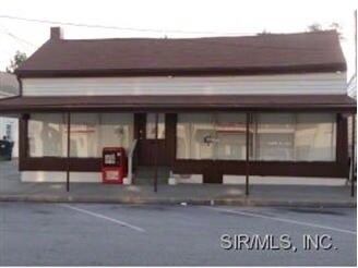
Property Record
114 N Main St, Waterloo, IL 62298

Save to a Folder
{{folder.Name}}
{{folder.ListingIds.length}} Properties
{{folder.ListingIds.length}} Property
Create a New Folder
Property Detail
114 N Main St
St. Louis, MO-IL
LOT 3A OLD TOWN
07-25-235-011-000
Monroe
Commercialnec
Illinois
WB3
3a
B and X Area of moderate flood hazard, usually the area between the limits of the 100-year and 500-year floods.
0.07 AC
2024
SE Metro Illinois
2025
St. Louis
600401
NEARBY LISTINGS FOR SALE OR LEASE
-
-
View all Waterloo listings for sale on LoopNet.com
DEMOGRAPHICS near 114 N Main St
1 mile
3 mile
5 mile
2025 Total Population
6,579
12,080
15,225
2030 Population
6,537
12,061
15,197
Pop Growth 2025-2030
(0.64%)
(0.16%)
(0.18%)
Average Age
42
42
43
2025 Total Households
2,759
4,893
6,075
HH Growth 2025-2030
(0.62%)
(0.14%)
(0.16%)
Median Household Inc
$80,168
$93,294
$96,286
Avg Household Size
2.30
2.40
2.40
2025 Avg HH Vehicles
2.00
2.00
2.00
Median Home Value
$230,844
$264,246
$278,544
Median Year Built
1975
1990
1990
Nearby Places
Map Layers
Map Styles
 Street
 Aerial
Layers
 Traffic
 Biking
Places
Listings with unknown addresses are not visible on the map
- Restaurants
- Banks
- Shops
- Fitness
- Groceries
PUBLIC TRANSPORTATION
AIRPORT
Scott AFB/Midamerica St Louis
Drive
Walk
Distance
Scott AFB/Midamerica St Louis
55 min
30.6 mi
St Louis Lambert International
Drive
Walk
Distance
St Louis Lambert International
56 min
37.5 mi
SALE & LEASE HISTORY
LISTING DATE
SALE/LEASE

Sep 23, 2016
For Sale
Nearby Properties
Address
Land Use
TOTAL SIZE
Lot Size
Zoning
Address
Land Use
TOTAL SIZE
Lot Size
Zoning
25.16 AC
WI1
Address
Land Use
TOTAL SIZE
Lot Size
Zoning
0.55 AC
WB3
Address
Land Use
TOTAL SIZE
Lot Size
Zoning
4 AC
WR5
Address
Land Use
TOTAL SIZE
Lot Size
Zoning
3.50 AC
WB3
Address
Land Use
TOTAL SIZE
Lot Size
Zoning
2.32 AC
WB2
Address
Land Use
TOTAL SIZE
Lot Size
Zoning
9.92 AC
WB2
Address
Land Use
TOTAL SIZE
Lot Size
Zoning
7.62 AC
MA2
Address
Land Use
TOTAL SIZE
Lot Size
Zoning
1.55 AC
MB2
Address
Land Use
TOTAL SIZE
Lot Size
Zoning
2.12 AC
WB2
Address
Land Use
TOTAL SIZE
Lot Size
Zoning
1.67 AC
WB2
Address
Land Use
TOTAL SIZE
Lot Size
Zoning
1.98 AC
WB2
Address
Land Use
TOTAL SIZE
Lot Size
Zoning
3.10 AC
WR5
Address
Land Use
TOTAL SIZE
Lot Size
Zoning
1.56 AC
WB3
Address
Land Use
TOTAL SIZE
Lot Size
Zoning
0.80 AC
WB3
Address
Land Use
TOTAL SIZE
Lot Size
Zoning
1.14 AC
WB3
Address
Land Use
TOTAL SIZE
Lot Size
Zoning
0.59 AC
Address
Land Use
TOTAL SIZE
Lot Size
Zoning
1.09 AC
WB3
Address
Land Use
TOTAL SIZE
Lot Size
Zoning
1.73 AC
WI1
Address
Land Use
TOTAL SIZE
Lot Size
Zoning
2,778 SF
1.06 AC
WB2
Address
Land Use
TOTAL SIZE
Lot Size
Zoning
1.72 AC
WB3
Address
Land Use
TOTAL SIZE
Lot Size
Zoning
1.23 AC
WB3
Address
Land Use
TOTAL SIZE
Lot Size
Zoning
0.98 AC
WB2
Address
Land Use
TOTAL SIZE
Lot Size
Zoning
1.35 AC
WB2
Address
Land Use
TOTAL SIZE
Lot Size
Zoning
3,277 SF
0.59 AC
WR5
Address
Land Use
TOTAL SIZE
Lot Size
Zoning
0.94 AC
WB3
Address
Land Use
TOTAL SIZE
Lot Size
Zoning
5 AC
WB3
Address
Land Use
TOTAL SIZE
Lot Size
Zoning
2.11 AC
WB2
Address
Land Use
TOTAL SIZE
Lot Size
Zoning
1.31 AC
WB3
Address
Land Use
TOTAL SIZE
Lot Size
Zoning
1.47 AC
WR1
Address
Land Use
TOTAL SIZE
Lot Size
Zoning
5.41 AC
WB3
The World's #1 Commercial Real Estate Marketplace
Connect with us
© 2026 CoStar Group
The information above has been obtained from sources believed reliable. While we do not doubt its accuracy we have not verified it and make no guarantee, warranty or representation about it. It is your responsibility to independently confirm its accuracy and completeness. Any projections, opinions, assumptions, or estimates used are for example only and do not represent the current or future performance of the property. The value of this transaction to you depends on tax and other factors which should be evaluated by your tax, financial, and legal advisors. You and your advisors should conduct a careful, independent investigation of the property to determine to your satisfaction the suitability of the property for your needs.