Property Record
114 Riverside Dr, Matamoras, PA 18336

Save to a Folder
{{folder.Name}}
{{folder.ListingIds.length}} Properties
{{folder.ListingIds.length}} Property
Create a New Folder
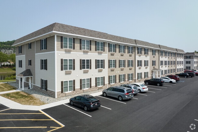
Property Detail
114 Riverside Dr
Hemlock Farms, PA
LOT1B (13.84 A)2 (36 UNITS) 24 UNIT 2 ( 12 UNT POOL CLUB H
121093
PIKE
Commercialnec
Pennsylvania
AE The base floodplain where base flood elevations are provided. AE Zones are now used on new format FIRMs instead of A1-A30 Zones.
1b
2025
13.84 AC
2026
Pike County
950104
Northern New Jersey
3,030 SF
NEARBY LISTINGS FOR SALE OR LEASE
-
-
View all Matamoras listings for sale on LoopNet.com
DEMOGRAPHICS near 114 Riverside Dr
1 mile
3 mile
5 mile
2025 Total Population
1,601
14,364
21,226
2030 Population
1,642
14,626
21,565
Pop Growth 2025-2030
+ 2.56%
+ 1.82%
+ 1.60%
Average Age
52
42
43
2025 Total Households
760
5,923
8,792
HH Growth 2025-2030
+ 2.76%
+ 1.89%
+ 1.62%
Median Household Inc
$62,738
$64,903
$69,210
Avg Household Size
2.00
2.30
2.30
2025 Avg HH Vehicles
2.00
2.00
2.00
Median Home Value
$285,945
$271,317
$286,850
Median Year Built
1989
1955
1967
Nearby Places
Map Layers
Map Styles
 Street
 Aerial
Layers
 Traffic
 Biking
Places
Listings with unknown addresses are not visible on the map
- Restaurants
- Banks
- Shops
- Fitness
- Groceries
PUBLIC TRANSPORTATION
COMMUTER RAIL
Port Jervis (Bergen County/Port Jervis Line - NJ Transit Commuter Rail (NJ Transit), Main/Port Jervis Line - NJ Transit Commuter Rail (NJ Transit))
Drive
Walk
Distance
Port Jervis (Bergen County/Port Jervis Line - NJ Transit Commuter Rail (NJ Transit), Main/Port Jervis Line - NJ Transit Commuter Rail (NJ Transit))
9 min
2.6 mi
Freight Ports
Port Newark Container Terminal
Drive
Walk
Distance
Port Newark Container Terminal
100 min
70.3 mi
Nearby Properties
Address
Land Use
TOTAL SIZE
Lot Size
Zoning
Address
Land Use
TOTAL SIZE
Lot Size
Zoning
4.40 AC
NMU
Address
Land Use
TOTAL SIZE
Lot Size
Zoning
1,664 SF
1.10 AC
R2
Address
Land Use
TOTAL SIZE
Lot Size
Zoning
21.10 AC
R1
Address
Land Use
TOTAL SIZE
Lot Size
Zoning
49.20 AC
Address
Land Use
TOTAL SIZE
Lot Size
Zoning
56,816 SF
7.80 AC
Address
Land Use
TOTAL SIZE
Lot Size
Zoning
16.92 AC
C2
Address
Land Use
TOTAL SIZE
Lot Size
Zoning
14,077 SF
2.20 AC
MCD
Address
Land Use
TOTAL SIZE
Lot Size
Zoning
336,976 SF
105.33 AC
Address
Land Use
TOTAL SIZE
Lot Size
Zoning
213,940 SF
31.45 AC
Address
Land Use
TOTAL SIZE
Lot Size
Zoning
4.10 AC
R2
Address
Land Use
TOTAL SIZE
Lot Size
Zoning
3,030 SF
10.50 AC
Address
Land Use
TOTAL SIZE
Lot Size
Zoning
577 AC
C-2
Address
Land Use
TOTAL SIZE
Lot Size
Zoning
215,446 SF
23.85 AC
Address
Land Use
TOTAL SIZE
Lot Size
Zoning
53,254 SF
4.10 AC
SCAH
Address
Land Use
TOTAL SIZE
Lot Size
Zoning
97,962 SF
8.90 AC
CBD
Address
Land Use
TOTAL SIZE
Lot Size
Zoning
20,914 SF
1.10 AC
NMU
Address
Land Use
TOTAL SIZE
Lot Size
Zoning
141,186 SF
15.22 AC
Address
Land Use
TOTAL SIZE
Lot Size
Zoning
56,864 SF
2.54 AC
Address
Land Use
TOTAL SIZE
Lot Size
Zoning
102,497 SF
3.90 AC
LI
Address
Land Use
TOTAL SIZE
Lot Size
Zoning
1 AC
C2
Address
Land Use
TOTAL SIZE
Lot Size
Zoning
205.69 AC
CD
Address
Land Use
TOTAL SIZE
Lot Size
Zoning
3.50 AC
C2
Address
Land Use
TOTAL SIZE
Lot Size
Zoning
3.48 AC
C-2
Address
Land Use
TOTAL SIZE
Lot Size
Zoning
72,575 SF
7.26 AC
Address
Land Use
TOTAL SIZE
Lot Size
Zoning
25,042 SF
2.10 AC
07
Address
Land Use
TOTAL SIZE
Lot Size
Zoning
3,007 SF
59.03 AC
R-1
Address
Land Use
TOTAL SIZE
Lot Size
Zoning
28,725 SF
1.40 AC
NMU
Address
Land Use
TOTAL SIZE
Lot Size
Zoning
87,263 SF
10.78 AC
Address
Land Use
TOTAL SIZE
Lot Size
Zoning
15,131 SF
3.50 AC
PWD
The World's #1 Commercial Real Estate Marketplace
Connect with us
© 2026 CoStar Group
The information above has been obtained from sources believed reliable. While we do not doubt its accuracy we have not verified it and make no guarantee, warranty or representation about it. It is your responsibility to independently confirm its accuracy and completeness. Any projections, opinions, assumptions, or estimates used are for example only and do not represent the current or future performance of the property. The value of this transaction to you depends on tax and other factors which should be evaluated by your tax, financial, and legal advisors. You and your advisors should conduct a careful, independent investigation of the property to determine to your satisfaction the suitability of the property for your needs.