Property Record
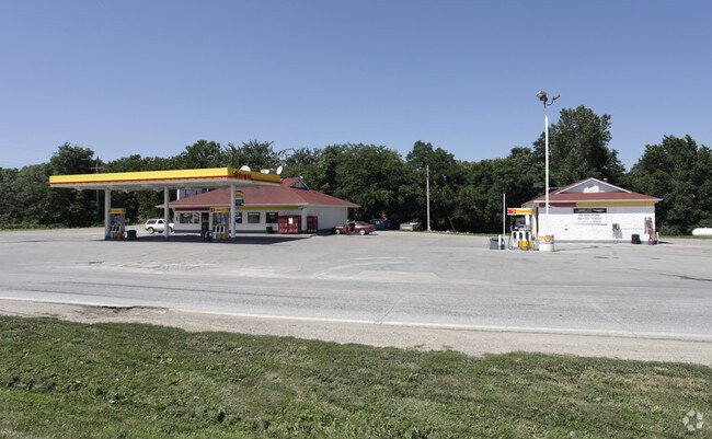
114 Rock Bluff Rd, Plattsmouth, NE 68048


NEARBY LISTINGS FOR SALE OR LEASE
-
-
View all Plattsmouth listings for sale on LoopNet.com
Property Detail
114 Rock Bluff Rd
130152927
13-11-13 L20 EXC SL1 OF 20 & HWY W1/2 NW1/4 (3.35)
Conveniencestore
Cass
X
Nebraska
31025C0275D
3.35 AC
2024
E Cass County
2025
Omaha/Council Bluffs
966000
Omaha-Council Bluffs, NE-IA
2,000 SF
DEMOGRAPHICS near 114 Rock Bluff Rd
1 Mile
3 Mile
5 Mile
2024 Total Population
841
3,912
6,834
2029 Population
887
4,133
7,201
Pop Growth 2024-2029
+ 5.47%
+ 5.65%
+ 5.37%
Average Age
42
43
42
2024 Total Households
312
1,498
2,639
HH Growth 2024-2029
+ 5.45%
+ 5.67%
+ 5.34%
Median Household Inc
$113,651
$99,476
$80,859
Avg Household Size
2.60
2.60
2.50
2024 Avg HH Vehicles
3.00
2.00
2.00
Median Home Value
$285,536
$293,141
$250,922
Median Year Built
1994
1991
1987
Nearby Places
Map Layers
Map Styles
 Street
 Aerial
- Restaurants
- Banks
- Shops
- Fitness
- Groceries
PUBLIC TRANSPORTATION
AIRPORT
Eppley Airfield
DRIVE
WALK
Distance
Eppley Airfield
45 min
30.4 mi
Nearby Properties
Address
Land Use
TOTAL SIZE
Lot Size
Zoning
Address
Land Use
TOTAL SIZE
Lot Size
Zoning
27,420 SF
15.92 AC
03-COMMERC
Address
Land Use
TOTAL SIZE
Lot Size
Zoning
7,327 SF
0.41 AC
06-RECREAT
Address
Land Use
TOTAL SIZE
Lot Size
Zoning
6,564 SF
3.51 AC
03-COMMERC
Address
Land Use
TOTAL SIZE
Lot Size
Zoning
158.53 AC
05-AGRICUL
Address
Land Use
TOTAL SIZE
Lot Size
Zoning
152.57 AC
05-AGRICUL
Address
Land Use
TOTAL SIZE
Lot Size
Zoning
6,000 SF
5 AC
03-COMMERC
Address
Land Use
TOTAL SIZE
Lot Size
Zoning
2,912 SF
5.19 AC
06-RECREAT
Address
Land Use
TOTAL SIZE
Lot Size
Zoning
80.03 AC
05-AGRICUL
Address
Land Use
TOTAL SIZE
Lot Size
Zoning
7,200 SF
3.89 AC
03-COMMERC
Address
Land Use
TOTAL SIZE
Lot Size
Zoning
3,852 SF
2.34 AC
03-COMMERC
Address
Land Use
TOTAL SIZE
Lot Size
Zoning
5,400 SF
5.16 AC
03-COMMERC
Address
Land Use
TOTAL SIZE
Lot Size
Zoning
2,520 SF
1.24 AC
03-COMMERC
Address
Land Use
TOTAL SIZE
Lot Size
Zoning
7,824 SF
2.79 AC
03-COMMERC
Address
Land Use
TOTAL SIZE
Lot Size
Zoning
9,600 SF
0.71 AC
03-COMMERC
Address
Land Use
TOTAL SIZE
Lot Size
Zoning
76.33 AC
05-AGRICUL
Address
Land Use
TOTAL SIZE
Lot Size
Zoning
0.39 AC
06-RECREAT
Address
Land Use
TOTAL SIZE
Lot Size
Zoning
3,360 SF
3.26 AC
03-COMMERC
Address
Land Use
TOTAL SIZE
Lot Size
Zoning
4,066 SF
3.71 AC
05-AGRICUL
Address
Land Use
TOTAL SIZE
Lot Size
Zoning
4,800 SF
0.99 AC
03-COMMERC
Address
Land Use
TOTAL SIZE
Lot Size
Zoning
715 SF
1.38 AC
03-COMMERC
Address
Land Use
TOTAL SIZE
Lot Size
Zoning
49.60 AC
05-AGRICUL
Address
Land Use
TOTAL SIZE
Lot Size
Zoning
6,840 SF
1.71 AC
03-COMMERC
Address
Land Use
TOTAL SIZE
Lot Size
Zoning
4,309 SF
0.29 AC
06-RECREAT
Address
Land Use
TOTAL SIZE
Lot Size
Zoning
6,300 SF
0.83 AC
03-COMMERC
Address
Land Use
TOTAL SIZE
Lot Size
Zoning
5,000 SF
0.51 AC
03-COMMERC
Address
Land Use
TOTAL SIZE
Lot Size
Zoning
15,000 SF
3 AC
05-AGRICUL
Address
Land Use
TOTAL SIZE
Lot Size
Zoning
3,159 SF
3.87 AC
06-RECREAT
The World's #1 Commercial Real Estate Marketplace
Connect with us
© 2025 CoStar Group
The information above has been obtained from sources believed reliable. While we do not doubt its accuracy we have not verified it and make no guarantee, warranty or representation about it. It is your responsibility to independently confirm its accuracy and completeness. Any projections, opinions, assumptions, or estimates used are for example only and do not represent the current or future performance of the property. The value of this transaction to you depends on tax and other factors which should be evaluated by your tax, financial, and legal advisors. You and your advisors should conduct a careful, independent investigation of the property to determine to your satisfaction the suitability of the property for your needs.