Property Record
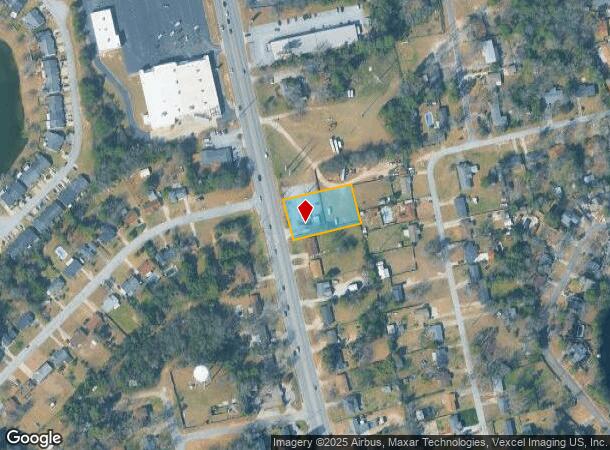
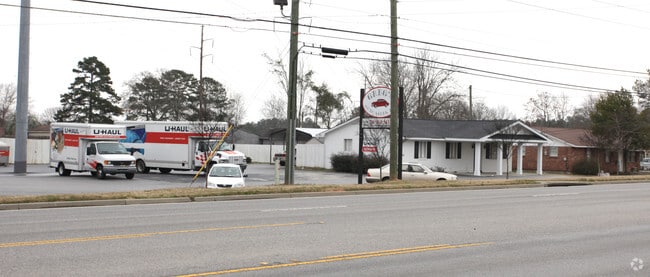
114 S Belair Rd, Augusta, GA 30907

NEARBY LISTINGS FOR SALE OR LEASE
Property Detail
114 S Belair Rd
Augusta-Richmond County, GA-SC
Highview Acres
073B053
BLK B LOT 15; HIGHVIEW ACRES SECT 2
Officebuilding
Columbia
X
Georgia
13073C0144E
15
2025
0.72 AC
2025
Evans/Martinez
030203
Augusta/Richmond County
1,075 SF
DEMOGRAPHICS near 114 S Belair Rd
1 mile
3 mile
5 mile
2024 Total Population
8,099
50,650
125,379
2029 Population
8,880
55,581
135,456
Pop Growth 2024-2029
+ 9.64%
+ 9.74%
+ 8.04%
Average Age
41
40
39
2024 Total Households
3,154
19,692
48,334
HH Growth 2024-2029
+ 8.75%
+ 8.67%
+ 6.94%
Median Household Inc
$61,728
$71,646
$75,975
Avg Household Size
2.50
2.50
2.50
2024 Avg HH Vehicles
2.00
2.00
2.00
Median Home Value
$168,994
$203,072
$228,058
Median Year Built
1981
1990
1993
Nearby Places
Map Layers
Map Styles
 Street
 Aerial
Transit
 Traffic
 Biking
Places
Listings with unknown addresses are not visible on the map
- Restaurants
- Banks
- Shops
- Fitness
- Groceries
PUBLIC TRANSPORTATION
AIRPORT
Augusta Regional at Bush Field
Drive
Walk
Distance
Augusta Regional at Bush Field
28 min
17.0 mi
Nearby Properties
Address
Land Use
TOTAL SIZE
Lot Size
Zoning
Address
Land Use
TOTAL SIZE
Lot Size
Zoning
371,617 SF
13.26 AC
B-2
Address
Land Use
TOTAL SIZE
Lot Size
Zoning
2,636 SF
73.21 AC
Address
Land Use
TOTAL SIZE
Lot Size
Zoning
4,357 SF
34 AC
R-3B
Address
Land Use
TOTAL SIZE
Lot Size
Zoning
4,077 SF
20.88 AC
C-2;GEN CO
Address
Land Use
TOTAL SIZE
Lot Size
Zoning
5,480 SF
19.05 AC
R-3B
Address
Land Use
TOTAL SIZE
Lot Size
Zoning
7,749 SF
17.02 AC
R2
Address
Land Use
TOTAL SIZE
Lot Size
Zoning
3,680 SF
13.42 AC
B-2
Address
Land Use
TOTAL SIZE
Lot Size
Zoning
92,482 SF
14.77 AC
Address
Land Use
TOTAL SIZE
Lot Size
Zoning
392 SF
19.66 AC
Address
Land Use
TOTAL SIZE
Lot Size
Zoning
4,265 SF
44.47 AC
S1
Address
Land Use
TOTAL SIZE
Lot Size
Zoning
100 SF
16.05 AC
Address
Land Use
TOTAL SIZE
Lot Size
Zoning
35,844 SF
38.03 AC
PUD
Address
Land Use
TOTAL SIZE
Lot Size
Zoning
61,236 SF
8.09 AC
R-3B
Address
Land Use
TOTAL SIZE
Lot Size
Zoning
952 SF
29 AC
A
Address
Land Use
TOTAL SIZE
Lot Size
Zoning
53,653 SF
11.26 AC
Address
Land Use
TOTAL SIZE
Lot Size
Zoning
2,508 SF
14.61 AC
A-R;APARTM
Address
Land Use
TOTAL SIZE
Lot Size
Zoning
199,464 SF
45.19 AC
Address
Land Use
TOTAL SIZE
Lot Size
Zoning
61,473 SF
PUD
Address
Land Use
TOTAL SIZE
Lot Size
Zoning
997 SF
19.16 AC
Address
Land Use
TOTAL SIZE
Lot Size
Zoning
6,000 SF
Address
Land Use
TOTAL SIZE
Lot Size
Zoning
6,000 SF
Address
Land Use
TOTAL SIZE
Lot Size
Zoning
150,263 SF
18.75 AC
PUD
Address
Land Use
TOTAL SIZE
Lot Size
Zoning
112,947 SF
14.91 AC
Address
Land Use
TOTAL SIZE
Lot Size
Zoning
72,381 SF
0.95 AC
Address
Land Use
TOTAL SIZE
Lot Size
Zoning
98,188 SF
13.29 AC
Address
Land Use
TOTAL SIZE
Lot Size
Zoning
129,068 SF
8.74 AC
Address
Land Use
TOTAL SIZE
Lot Size
Zoning
11,584 SF
10.34 AC
R-3B
Address
Land Use
TOTAL SIZE
Lot Size
Zoning
226,626 SF
34.18 AC
B-2_A
Address
Land Use
TOTAL SIZE
Lot Size
Zoning
226,626 SF
34.18 AC
B-2_A
Address
Land Use
TOTAL SIZE
Lot Size
Zoning
75,000 SF
12.90 AC
The World's #1 Commercial Real Estate Marketplace
Connect with us
© 2026 CoStar Group
The information above has been obtained from sources believed reliable. While we do not doubt its accuracy we have not verified it and make no guarantee, warranty or representation about it. It is your responsibility to independently confirm its accuracy and completeness. Any projections, opinions, assumptions, or estimates used are for example only and do not represent the current or future performance of the property. The value of this transaction to you depends on tax and other factors which should be evaluated by your tax, financial, and legal advisors. You and your advisors should conduct a careful, independent investigation of the property to determine to your satisfaction the suitability of the property for your needs.