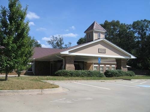
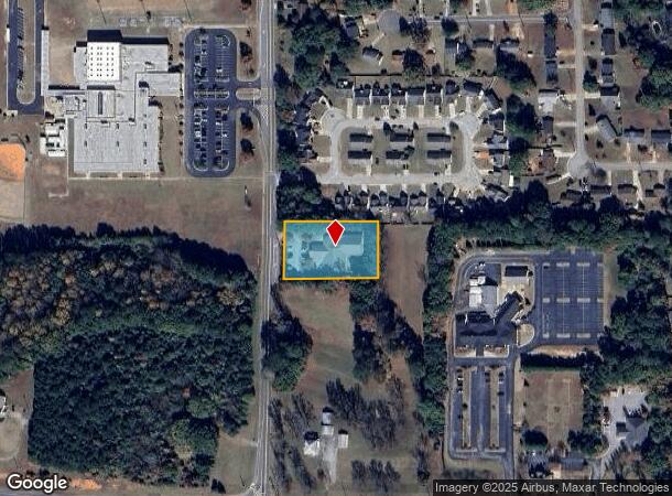
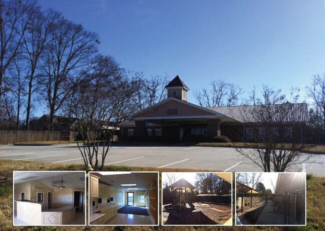
Property Record
1140 Cowan Rd, Griffin, GA 30223
NEARBY LISTINGS FOR SALE OR LEASE
Property Detail
1140 Cowan Rd
Atlanta-Sandy Springs-Roswell, GA
Carver Heights
248B-01-003
LL 94 COWAN RD PB 4/453 0.938 AC
Daycare
Spalding
X
Georgia
13255C0068D
94
2024
0.94 AC
2024
W Henry/Spalding
160500
Atlanta
8,282 SF
DEMOGRAPHICS near 1140 Cowan Rd
1 Mile
3 Mile
5 Mile
2024 Total Population
3,536
23,729
48,420
2029 Population
3,759
25,247
51,377
Pop Growth 2024-2029
+ 6.31%
+ 6.40%
+ 6.11%
Average Age
38
37
39
2024 Total Households
1,319
8,795
18,494
HH Growth 2024-2029
+ 6.29%
+ 6.36%
+ 6.06%
Median Household Inc
$59,956
$43,999
$49,426
Avg Household Size
2.60
2.60
2.50
2024 Avg HH Vehicles
2.00
2.00
2.00
Median Home Value
$145,425
$128,595
$169,055
Median Year Built
1992
1977
1979
Nearby Places
Map Layers
Map Styles
 Street
 Aerial
- Restaurants
- Banks
- Shops
- Fitness
- Groceries
PUBLIC TRANSPORTATION
AIRPORT
Hartsfield - Jackson Atlanta International
DRIVE
WALK
Distance
Hartsfield - Jackson Atlanta International
47 min
30.0 mi
Freight Ports
Georgia Ports - Savannah
DRIVE
WALK
Distance
Georgia Ports - Savannah
252 min
221.3 mi
Nearby Properties
Address
Land Use
TOTAL SIZE
Lot Size
Zoning
Address
Land Use
TOTAL SIZE
Lot Size
Zoning
112,554 SF
40.27 AC
C2
Address
Land Use
TOTAL SIZE
Lot Size
Zoning
200,880 SF
21.14 AC
PCD
Address
Land Use
TOTAL SIZE
Lot Size
Zoning
2,876 SF
19.98 AC
HDRB
Address
Land Use
TOTAL SIZE
Lot Size
Zoning
89,096 SF
22.41 AC
PCD
Address
Land Use
TOTAL SIZE
Lot Size
Zoning
133.41 AC
INST
Address
Land Use
TOTAL SIZE
Lot Size
Zoning
89.45 AC
INST
Address
Land Use
TOTAL SIZE
Lot Size
Zoning
221,554 SF
23.89 AC
PCD
Address
Land Use
TOTAL SIZE
Lot Size
Zoning
96,787 SF
14.07 AC
LDRB
Address
Land Use
TOTAL SIZE
Lot Size
Zoning
10,000 SF
11.82 AC
PCD
Address
Land Use
TOTAL SIZE
Lot Size
Zoning
118,410 SF
15.42 AC
LDRB
Address
Land Use
TOTAL SIZE
Lot Size
Zoning
115,608 SF
20.92 AC
R3
Address
Land Use
TOTAL SIZE
Lot Size
Zoning
55.08 AC
R-1
Address
Land Use
TOTAL SIZE
Lot Size
Zoning
47,652 SF
2.59 AC
PCD
Address
Land Use
TOTAL SIZE
Lot Size
Zoning
4,118 SF
14.40 AC
PID
Address
Land Use
TOTAL SIZE
Lot Size
Zoning
72,870 SF
30 AC
Address
Land Use
TOTAL SIZE
Lot Size
Zoning
11,520 SF
8.77 AC
C-1B
Address
Land Use
TOTAL SIZE
Lot Size
Zoning
304,000 SF
11.92 AC
Address
Land Use
TOTAL SIZE
Lot Size
Zoning
59,700 SF
2.20 AC
CBD
Address
Land Use
TOTAL SIZE
Lot Size
Zoning
102,102 SF
10.84 AC
PCD
Address
Land Use
TOTAL SIZE
Lot Size
Zoning
41,830 SF
6.41 AC
INST
Address
Land Use
TOTAL SIZE
Lot Size
Zoning
98,330 SF
0.96 AC
CBD
Address
Land Use
TOTAL SIZE
Lot Size
Zoning
65,702 SF
7.19 AC
PCD
Address
Land Use
TOTAL SIZE
Lot Size
Zoning
111,214 SF
6.01 AC
PCD
Address
Land Use
TOTAL SIZE
Lot Size
Zoning
18.07 AC
R1
Address
Land Use
TOTAL SIZE
Lot Size
Zoning
14.73 AC
INST
Address
Land Use
TOTAL SIZE
Lot Size
Zoning
50,382 SF
3.32 AC
C1
Address
Land Use
TOTAL SIZE
Lot Size
Zoning
22,158 SF
3.52 AC
C2
Address
Land Use
TOTAL SIZE
Lot Size
Zoning
52,636 SF
2.69 AC
PCD
Address
Land Use
TOTAL SIZE
Lot Size
Zoning
63,109 SF
3.35 AC
INST
Address
Land Use
TOTAL SIZE
Lot Size
Zoning
21,480 SF
7.41 AC
PCD
The World's #1 Commercial Real Estate Marketplace
Connect with us
© 2026 CoStar Group
The information above has been obtained from sources believed reliable. While we do not doubt its accuracy we have not verified it and make no guarantee, warranty or representation about it. It is your responsibility to independently confirm its accuracy and completeness. Any projections, opinions, assumptions, or estimates used are for example only and do not represent the current or future performance of the property. The value of this transaction to you depends on tax and other factors which should be evaluated by your tax, financial, and legal advisors. You and your advisors should conduct a careful, independent investigation of the property to determine to your satisfaction the suitability of the property for your needs.