Property Record
11404 S 301 Hwy S, Riverview, FL 33569

NEARBY LISTINGS FOR SALE OR LEASE
Property Detail
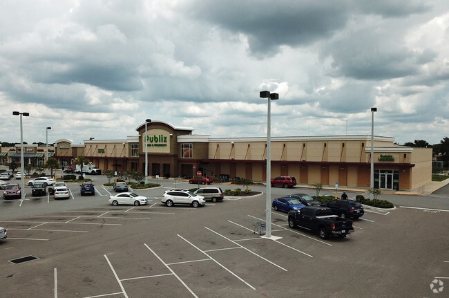
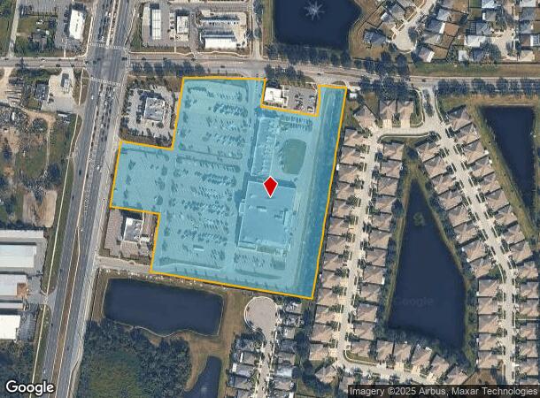
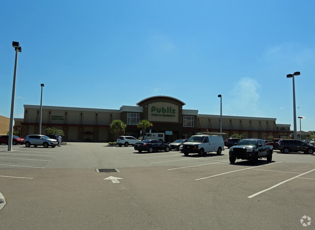
11404 S 301 Hwy S
Tampa-St. Petersburg-Clearwater, FL
Rivercrest Commons
U-32-30-20-B13-000000-00004.0
RIVERCREST COMMONS LOT 4
Regionalshoppingcenterormallwithanchorstore
Hillsborough
AE
Florida
12057C0504J
4
2024
12.44 AC
2024
Eastern Outlying
013919
Tampa/St Petersburg
70,603 SF
DEMOGRAPHICS near 11404 S 301 Hwy S
1 Mile
3 Mile
5 Mile
2024 Total Population
14,532
79,680
191,519
2029 Population
16,149
87,577
211,222
Pop Growth 2024-2029
+ 11.13%
+ 9.91%
+ 10.29%
Average Age
37
37
37
2024 Total Households
5,032
27,019
66,322
HH Growth 2024-2029
+ 11.21%
+ 10.16%
+ 10.46%
Median Household Inc
$80,327
$84,230
$84,829
Avg Household Size
2.90
2.90
2.90
2024 Avg HH Vehicles
2.00
2.00
2.00
Median Home Value
$273,432
$276,412
$288,263
Median Year Built
2008
2005
2006
Nearby Places
Map Layers
Map Styles
 Street
 Aerial
- Restaurants
- Banks
- Shops
- Fitness
- Groceries
PUBLIC TRANSPORTATION
AIRPORT
Tampa International
DRIVE
WALK
Distance
Tampa International
37 min
22.7 mi
St Pete-Clearwater International
DRIVE
WALK
Distance
St Pete-Clearwater International
54 min
32.7 mi
Sarasota/Bradenton International
DRIVE
WALK
Distance
Sarasota/Bradenton International
58 min
39.2 mi
Nearby Properties
Address
Land Use
TOTAL SIZE
Lot Size
Zoning
Address
Land Use
TOTAL SIZE
Lot Size
Zoning
382,521 SF
24.27 AC
PD
Address
Land Use
TOTAL SIZE
Lot Size
Zoning
399,150 SF
26.32 AC
PD
Address
Land Use
TOTAL SIZE
Lot Size
Zoning
370,924 SF
73.35 AC
PD
Address
Land Use
TOTAL SIZE
Lot Size
Zoning
289,109 SF
75.56 AC
AR
Address
Land Use
TOTAL SIZE
Lot Size
Zoning
124,865 SF
20.14 AC
PD
Address
Land Use
TOTAL SIZE
Lot Size
Zoning
164,852 SF
15.26 AC
PD
Address
Land Use
TOTAL SIZE
Lot Size
Zoning
64,248 SF
17.86 AC
PD
Address
Land Use
TOTAL SIZE
Lot Size
Zoning
163,701 SF
87.66 AC
PD
Address
Land Use
TOTAL SIZE
Lot Size
Zoning
74,246 SF
9.75 AC
AR
Address
Land Use
TOTAL SIZE
Lot Size
Zoning
97,039 SF
35.42 AC
PD
Address
Land Use
TOTAL SIZE
Lot Size
Zoning
215,929 SF
26.74 AC
PD
Address
Land Use
TOTAL SIZE
Lot Size
Zoning
67,026 SF
21.92 AC
PD
Address
Land Use
TOTAL SIZE
Lot Size
Zoning
71,836 SF
42.82 AC
ASC-1
Address
Land Use
TOTAL SIZE
Lot Size
Zoning
101,809 SF
15.02 AC
PD
Address
Land Use
TOTAL SIZE
Lot Size
Zoning
98,325 SF
20.75 AC
PD
Address
Land Use
TOTAL SIZE
Lot Size
Zoning
75,304 SF
4.27 AC
PD
Address
Land Use
TOTAL SIZE
Lot Size
Zoning
87,925 SF
4.38 AC
PD
Address
Land Use
TOTAL SIZE
Lot Size
Zoning
113,296 SF
23.90 AC
PD
Address
Land Use
TOTAL SIZE
Lot Size
Zoning
51,872 SF
4.50 AC
PD
Address
Land Use
TOTAL SIZE
Lot Size
Zoning
89,725 SF
23.64 AC
PD
Address
Land Use
TOTAL SIZE
Lot Size
Zoning
75,207 SF
8.57 AC
PD
Address
Land Use
TOTAL SIZE
Lot Size
Zoning
79,150 SF
14.65 AC
PD
Address
Land Use
TOTAL SIZE
Lot Size
Zoning
75,470 SF
4.21 AC
PD
Address
Land Use
TOTAL SIZE
Lot Size
Zoning
71,818 SF
13.94 AC
PD
Address
Land Use
TOTAL SIZE
Lot Size
Zoning
924 SF
563.45 AC
AR
Address
Land Use
TOTAL SIZE
Lot Size
Zoning
99,066 SF
17.21 AC
RSC-6
Address
Land Use
TOTAL SIZE
Lot Size
Zoning
101,880 SF
6.53 AC
PD
Address
Land Use
TOTAL SIZE
Lot Size
Zoning
58,866 SF
1.80 AC
PD
Address
Land Use
TOTAL SIZE
Lot Size
Zoning
138,298 SF
14.66 AC
PD
The World's #1 Commercial Real Estate Marketplace
Connect with us
© 2026 CoStar Group
The information above has been obtained from sources believed reliable. While we do not doubt its accuracy we have not verified it and make no guarantee, warranty or representation about it. It is your responsibility to independently confirm its accuracy and completeness. Any projections, opinions, assumptions, or estimates used are for example only and do not represent the current or future performance of the property. The value of this transaction to you depends on tax and other factors which should be evaluated by your tax, financial, and legal advisors. You and your advisors should conduct a careful, independent investigation of the property to determine to your satisfaction the suitability of the property for your needs.