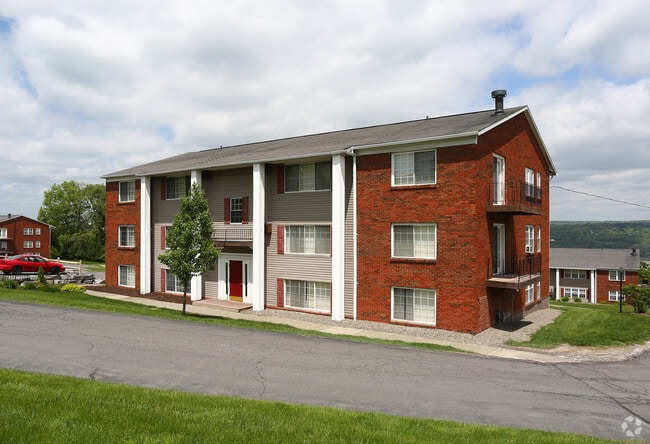
Property Record
1141 Trumansburg Rd, Ithaca, NY 14850


Save to a Folder
{{folder.Name}}
{{folder.ListingIds.length}} Properties
{{folder.ListingIds.length}} Property
Create a New Folder
Property Detail
1141 Trumansburg Rd
503089-026-000-0004-033-000-0000
TOMPKINS
Apartment
New York
B and X Area of moderate flood hazard, usually the area between the limits of the 100-year and 500-year floods.
33.000
2025
5.87 AC
2025
Northwest Ithaca
000700
Other Market Areas
10,320 SF
Ithaca, NY
NEARBY LISTINGS FOR SALE OR LEASE
DEMOGRAPHICS near 1141 Trumansburg Rd
1 mile
3 mile
5 mile
2025 Total Population
1,714
43,072
68,049
2030 Population
1,709
43,203
68,206
Pop Growth 2025-2030
(0.29%)
+ 0.30%
+ 0.23%
Average Age
46
35
35
2025 Total Households
771
17,123
25,909
HH Growth 2025-2030
(0.65%)
+ 0.22%
+ 0.17%
Median Household Inc
$63,088
$56,650
$63,356
Avg Household Size
1.90
2.00
2.00
2025 Avg HH Vehicles
2.00
1.00
1.00
Median Home Value
$333,490
$363,791
$344,753
Median Year Built
1970
1973
1975
Nearby Places
Map Layers
Map Styles
 Street
 Aerial
Layers
 Traffic
 Biking
Places
Listings with unknown addresses are not visible on the map
- Restaurants
- Banks
- Shops
- Fitness
- Groceries
PUBLIC TRANSPORTATION
AIRPORT
Ithaca Tompkins International
Drive
Walk
Distance
Ithaca Tompkins International
12 min
7.1 mi
Elmira/Corning Regional
Drive
Walk
Distance
Elmira/Corning Regional
47 min
35.5 mi
Freight Ports
Albany, NY Port
Drive
Walk
Distance
Albany, NY Port
223 min
168.6 mi
Nearby Properties
Address
Land Use
TOTAL SIZE
Lot Size
Zoning
Address
Land Use
TOTAL SIZE
Lot Size
Zoning
5,000 SF
154.28 AC
U-1
Address
Land Use
TOTAL SIZE
Lot Size
Zoning
36,275 SF
157.84 AC
Address
Land Use
TOTAL SIZE
Lot Size
Zoning
338,706 SF
2.08 AC
U-1
Address
Land Use
TOTAL SIZE
Lot Size
Zoning
1.30 AC
U-1
Address
Land Use
TOTAL SIZE
Lot Size
Zoning
19,600 SF
22.51 AC
P-1
Address
Land Use
TOTAL SIZE
Lot Size
Zoning
218,211 SF
0.76 AC
CBD-60
Address
Land Use
TOTAL SIZE
Lot Size
Zoning
150,015 SF
4.94 AC
U-1
Address
Land Use
TOTAL SIZE
Lot Size
Zoning
125,988 SF
0.61 AC
CBD-60
Address
Land Use
TOTAL SIZE
Lot Size
Zoning
199,578 SF
0.56 AC
CBD-60
Address
Land Use
TOTAL SIZE
Lot Size
Zoning
364,128 SF
107.14 AC
Address
Land Use
TOTAL SIZE
Lot Size
Zoning
131,532 SF
2.20 AC
U-1
Address
Land Use
TOTAL SIZE
Lot Size
Zoning
8,100 SF
0.51 AC
CBD-60
Address
Land Use
TOTAL SIZE
Lot Size
Zoning
115,796 SF
27.79 AC
Address
Land Use
TOTAL SIZE
Lot Size
Zoning
0.93 AC
U-1
Address
Land Use
TOTAL SIZE
Lot Size
Zoning
228,978 SF
4.96 AC
Address
Land Use
TOTAL SIZE
Lot Size
Zoning
112,392 SF
0.79 AC
B-2B
Address
Land Use
TOTAL SIZE
Lot Size
Zoning
185,997 SF
0.65 AC
CBD-140
Address
Land Use
TOTAL SIZE
Lot Size
Zoning
26,658 SF
0.69 AC
R-3A
Address
Land Use
TOTAL SIZE
Lot Size
Zoning
5,555 SF
12.07 AC
P-1
Address
Land Use
TOTAL SIZE
Lot Size
Zoning
91,872 SF
0.76 AC
R-3B
Address
Land Use
TOTAL SIZE
Lot Size
Zoning
792 SF
49.77 AC
Address
Land Use
TOTAL SIZE
Lot Size
Zoning
114,085 SF
0.77 AC
B-2C
Address
Land Use
TOTAL SIZE
Lot Size
Zoning
75,861 SF
0.97 AC
B-2B
Address
Land Use
TOTAL SIZE
Lot Size
Zoning
18.70 AC
Address
Land Use
TOTAL SIZE
Lot Size
Zoning
171,299 SF
3.59 AC
Address
Land Use
TOTAL SIZE
Lot Size
Zoning
43,592 SF
1.71 AC
P-1
Address
Land Use
TOTAL SIZE
Lot Size
Zoning
59,626 SF
0.65 AC
R-3B
Address
Land Use
TOTAL SIZE
Lot Size
Zoning
17,427 SF
13.17 AC
Address
Land Use
TOTAL SIZE
Lot Size
Zoning
64,708 SF
1.13 AC
B-2C
The World's #1 Commercial Real Estate Marketplace
Connect with us
© 2026 CoStar Group
The information above has been obtained from sources believed reliable. While we do not doubt its accuracy we have not verified it and make no guarantee, warranty or representation about it. It is your responsibility to independently confirm its accuracy and completeness. Any projections, opinions, assumptions, or estimates used are for example only and do not represent the current or future performance of the property. The value of this transaction to you depends on tax and other factors which should be evaluated by your tax, financial, and legal advisors. You and your advisors should conduct a careful, independent investigation of the property to determine to your satisfaction the suitability of the property for your needs.