Property Record
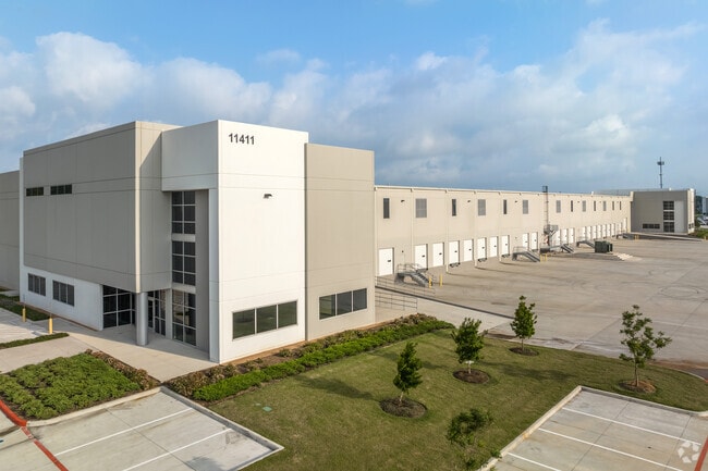
11411 Tanyard Creek Dr, Houston, TX 77040


NEARBY LISTINGS FOR SALE OR LEASE
Property Detail
11411 Tanyard Creek Dr
Houston-Pasadena-The Woodlands, TX
Breen Reserve Sec 1
1457060010002
RES B BLK 1 (INDUSTRIAL) BREEN RESERVE SEC 1
Warehouse
Harris
2024
Texas
2025
14.75 AC
532502
Hwy 290/Tomball Pky
232,702 SF
Houston
DEMOGRAPHICS near 11411 Tanyard Creek Dr
1 Mile
3 Mile
5 Mile
2024 Total Population
11,696
105,997
285,977
2029 Population
11,738
106,948
289,703
Pop Growth 2024-2029
+ 0.36%
+ 0.90%
+ 1.30%
Average Age
36
36
36
2024 Total Households
3,289
33,814
93,289
HH Growth 2024-2029
+ 0.27%
+ 0.77%
+ 1.25%
Median Household Inc
$65,817
$57,487
$54,100
Avg Household Size
3.50
3.10
3.00
2024 Avg HH Vehicles
3.00
2.00
2.00
Median Home Value
$164,502
$175,344
$182,429
Median Year Built
1979
1984
1984
Nearby Places
Map Layers
Map Styles
 Street
 Aerial
- Restaurants
- Banks
- Shops
- Fitness
- Groceries
PUBLIC TRANSPORTATION
AIRPORT
George Bush Intcntl/Houston
DRIVE
WALK
Distance
George Bush Intcntl/Houston
22 min
16.3 mi
William P Hobby
DRIVE
WALK
Distance
William P Hobby
45 min
27.6 mi
Freight Ports
Port of Houston
DRIVE
WALK
Distance
Port of Houston
37 min
24.9 mi
SALE & LEASE HISTORY
LISTING DATE
SALE/LEASE

Feb 07, 2022
For Sale
Nearby Properties
Address
Land Use
TOTAL SIZE
Lot Size
Zoning
Address
Land Use
TOTAL SIZE
Lot Size
Zoning
552,757 SF
32.95 AC
Address
Land Use
TOTAL SIZE
Lot Size
Zoning
643,804 SF
31.40 AC
Address
Land Use
TOTAL SIZE
Lot Size
Zoning
527,744 SF
35.46 AC
Address
Land Use
TOTAL SIZE
Lot Size
Zoning
397,248 SF
26.37 AC
Address
Land Use
TOTAL SIZE
Lot Size
Zoning
456,294 SF
19.02 AC
Address
Land Use
TOTAL SIZE
Lot Size
Zoning
365,380 SF
19.17 AC
Address
Land Use
TOTAL SIZE
Lot Size
Zoning
495,024 SF
23.96 AC
Address
Land Use
TOTAL SIZE
Lot Size
Zoning
502,860 SF
40.99 AC
Address
Land Use
TOTAL SIZE
Lot Size
Zoning
399,828 SF
20.32 AC
Address
Land Use
TOTAL SIZE
Lot Size
Zoning
308,168 SF
21.34 AC
Address
Land Use
TOTAL SIZE
Lot Size
Zoning
426,748 SF
26.09 AC
Address
Land Use
TOTAL SIZE
Lot Size
Zoning
361,800 SF
18.20 AC
Address
Land Use
TOTAL SIZE
Lot Size
Zoning
401,600 SF
20.48 AC
Address
Land Use
TOTAL SIZE
Lot Size
Zoning
409,271 SF
20.70 AC
Address
Land Use
TOTAL SIZE
Lot Size
Zoning
347,694 SF
17.61 AC
Address
Land Use
TOTAL SIZE
Lot Size
Zoning
447,480 SF
18.48 AC
Address
Land Use
TOTAL SIZE
Lot Size
Zoning
357,300 SF
23.38 AC
Address
Land Use
TOTAL SIZE
Lot Size
Zoning
185,252 SF
17.14 AC
Address
Land Use
TOTAL SIZE
Lot Size
Zoning
297,351 SF
13.47 AC
Address
Land Use
TOTAL SIZE
Lot Size
Zoning
215,968 SF
17.23 AC
Address
Land Use
TOTAL SIZE
Lot Size
Zoning
356,656 SF
23.54 AC
Address
Land Use
TOTAL SIZE
Lot Size
Zoning
299,280 SF
15.71 AC
Address
Land Use
TOTAL SIZE
Lot Size
Zoning
292,112 SF
4.41 AC
Address
Land Use
TOTAL SIZE
Lot Size
Zoning
268,678 SF
14 AC
Address
Land Use
TOTAL SIZE
Lot Size
Zoning
322,226 SF
14.99 AC
Address
Land Use
TOTAL SIZE
Lot Size
Zoning
257,400 SF
13.34 AC
Address
Land Use
TOTAL SIZE
Lot Size
Zoning
299,640 SF
13.95 AC
Address
Land Use
TOTAL SIZE
Lot Size
Zoning
614,712 SF
7.93 AC
Address
Land Use
TOTAL SIZE
Lot Size
Zoning
241,340 SF
12.50 AC
Address
Land Use
TOTAL SIZE
Lot Size
Zoning
241,190 SF
13.98 AC
The World's #1 Commercial Real Estate Marketplace
Connect with us
© 2026 CoStar Group
The information above has been obtained from sources believed reliable. While we do not doubt its accuracy we have not verified it and make no guarantee, warranty or representation about it. It is your responsibility to independently confirm its accuracy and completeness. Any projections, opinions, assumptions, or estimates used are for example only and do not represent the current or future performance of the property. The value of this transaction to you depends on tax and other factors which should be evaluated by your tax, financial, and legal advisors. You and your advisors should conduct a careful, independent investigation of the property to determine to your satisfaction the suitability of the property for your needs.