Property Record
11415 Main St, Roscoe, IL 61073

Save to a Folder
{{folder.Name}}
{{folder.ListingIds.length}} Properties
{{folder.ListingIds.length}} Property
Create a New Folder
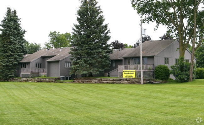
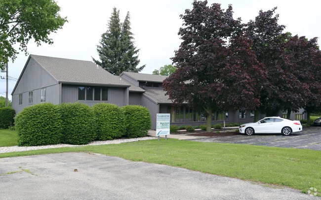
Property Detail
11415 Main St
04-33-128-002
TRI TR MEAS 8.43 FT N LN & 86.25 FT WLN LYG NW COR OF ELY 1.50A OF IRR TR &ELY 1.50A TR BOUNDED ON THE N BY ELEVATOR RD ABAND & ON THE E BY 76-02-1386
Officebuilding
Winnebago
CG - COMM
Illinois
B and X Area of moderate flood hazard, usually the area between the limits of the 100-year and 500-year floods.
11
2025
1.50 AC
2025
I-39 Corr/Winnebago Cnty
003904
Chicago
6,908 SF
Rockford, IL
NEARBY LISTINGS FOR SALE OR LEASE
-
-
View all Roscoe listings for sale on LoopNet.com
DEMOGRAPHICS near 11415 Main St
1 mile
3 mile
5 mile
2025 Total Population
3,203
23,916
51,453
2030 Population
3,263
23,907
51,663
Pop Growth 2025-2030
+ 1.87%
(0.04%)
+ 0.41%
Average Age
42
41
41
2025 Total Households
1,308
8,852
19,609
HH Growth 2025-2030
+ 1.91%
+ 0.03%
+ 0.42%
Median Household Inc
$86,187
$100,712
$93,011
Avg Household Size
2.40
2.70
2.60
2025 Avg HH Vehicles
2.00
2.00
2.00
Median Home Value
$197,820
$238,111
$220,906
Median Year Built
1987
1994
1992
Nearby Places
Map Layers
Map Styles
 Street
 Aerial
Layers
 Traffic
 Biking
Places
Listings with unknown addresses are not visible on the map
- Restaurants
- Banks
- Shops
- Fitness
- Groceries
PUBLIC TRANSPORTATION
AIRPORT
Chicago/Rockford International
Drive
Walk
Distance
Chicago/Rockford International
40 min
21.2 mi
SALE & LEASE HISTORY
LISTING DATE
SALE/LEASE

Dec 08, 2022
For Sale
Nearby Properties
Address
Land Use
TOTAL SIZE
Lot Size
Zoning
Address
Land Use
TOTAL SIZE
Lot Size
Zoning
121.46 AC
Address
Land Use
TOTAL SIZE
Lot Size
Zoning
33.53 AC
Address
Land Use
TOTAL SIZE
Lot Size
Zoning
66.74 AC
Address
Land Use
TOTAL SIZE
Lot Size
Zoning
8 AC
CN - COMM
Address
Land Use
TOTAL SIZE
Lot Size
Zoning
Address
Land Use
TOTAL SIZE
Lot Size
Zoning
18.56 AC
Address
Land Use
TOTAL SIZE
Lot Size
Zoning
8.61 AC
Address
Land Use
TOTAL SIZE
Lot Size
Zoning
82,123 SF
1 AC
Address
Land Use
TOTAL SIZE
Lot Size
Zoning
218,074 SF
39.93 AC
IG GENERAL
Address
Land Use
TOTAL SIZE
Lot Size
Zoning
13.10 AC
Address
Land Use
TOTAL SIZE
Lot Size
Zoning
Address
Land Use
TOTAL SIZE
Lot Size
Zoning
52.23 AC
Address
Land Use
TOTAL SIZE
Lot Size
Zoning
11.42 AC
Address
Land Use
TOTAL SIZE
Lot Size
Zoning
4.56 AC
Address
Land Use
TOTAL SIZE
Lot Size
Zoning
Address
Land Use
TOTAL SIZE
Lot Size
Zoning
2.22 AC
Address
Land Use
TOTAL SIZE
Lot Size
Zoning
Address
Land Use
TOTAL SIZE
Lot Size
Zoning
9.98 AC
Address
Land Use
TOTAL SIZE
Lot Size
Zoning
7.70 AC
IL LIGHT I
Address
Land Use
TOTAL SIZE
Lot Size
Zoning
41,400 SF
9.92 AC
Address
Land Use
TOTAL SIZE
Lot Size
Zoning
Address
Land Use
TOTAL SIZE
Lot Size
Zoning
2.98 AC
Address
Land Use
TOTAL SIZE
Lot Size
Zoning
3,744 SF
12.71 AC
Address
Land Use
TOTAL SIZE
Lot Size
Zoning
6.30 AC
Address
Land Use
TOTAL SIZE
Lot Size
Zoning
294,355 SF
53.53 AC
IG GENERAL
Address
Land Use
TOTAL SIZE
Lot Size
Zoning
86,261 SF
12.72 AC
Address
Land Use
TOTAL SIZE
Lot Size
Zoning
7,031 SF
4.60 AC
IL
Address
Land Use
TOTAL SIZE
Lot Size
Zoning
39,445 SF
3.28 AC
CG - COMM
Address
Land Use
TOTAL SIZE
Lot Size
Zoning
6.69 AC
Address
Land Use
TOTAL SIZE
Lot Size
Zoning
15,750 SF
2 AC
The World's #1 Commercial Real Estate Marketplace
Connect with us
© 2026 CoStar Group
The information above has been obtained from sources believed reliable. While we do not doubt its accuracy we have not verified it and make no guarantee, warranty or representation about it. It is your responsibility to independently confirm its accuracy and completeness. Any projections, opinions, assumptions, or estimates used are for example only and do not represent the current or future performance of the property. The value of this transaction to you depends on tax and other factors which should be evaluated by your tax, financial, and legal advisors. You and your advisors should conduct a careful, independent investigation of the property to determine to your satisfaction the suitability of the property for your needs.