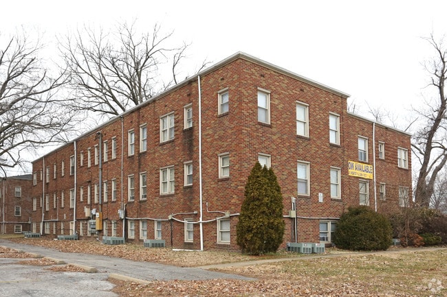
Property Record
1143 Covert Ave, Evansville, IN 47714

NEARBY LISTINGS FOR SALE OR LEASE
Property Detail
1143 Covert Ave
82-06-33-011-035.001-027
Berlin Heights
Apartment
PT NW SW 33-6-10 BERLIN HTS 2
X
Vanderburgh
18163C0185E
Indiana
2024
1.48 AC
2024
East Evansville
001000
Evansville
11,490 SF
Evansville, IN-KY
DEMOGRAPHICS near 1143 Covert Ave
1 Mile
3 Mile
5 Mile
2024 Total Population
15,318
64,115
118,476
2029 Population
15,607
65,162
119,216
Pop Growth 2024-2029
+ 1.89%
+ 1.63%
+ 0.62%
Average Age
37
39
40
2024 Total Households
6,230
27,416
52,224
HH Growth 2024-2029
+ 1.86%
+ 1.72%
+ 0.62%
Median Household Inc
$45,487
$44,964
$47,610
Avg Household Size
2.30
2.20
2.10
2024 Avg HH Vehicles
2.00
2.00
2.00
Median Home Value
$70,012
$85,739
$115,600
Median Year Built
1949
1953
1959
Nearby Places
Map Layers
Map Styles
 Street
 Aerial
- Restaurants
- Banks
- Shops
- Fitness
- Groceries
PUBLIC TRANSPORTATION
AIRPORT
Evansville Regional
DRIVE
WALK
Distance
Evansville Regional
13 min
6.2 mi
Freight Ports
Port of Toledo
DRIVE
WALK
Distance
Port of Toledo
461 min
395.5 mi
SALE & LEASE HISTORY
LISTING DATE
SALE/LEASE

Mar 19, 2020
For Sale
Dec 01, 2016
For Sale
Nearby Properties
Address
Land Use
TOTAL SIZE
Lot Size
Zoning
Address
Land Use
TOTAL SIZE
Lot Size
Zoning
84,660 SF
12.95 AC
Address
Land Use
TOTAL SIZE
Lot Size
Zoning
20,964 SF
1.35 AC
Address
Land Use
TOTAL SIZE
Lot Size
Zoning
15,233 SF
3.31 AC
Address
Land Use
TOTAL SIZE
Lot Size
Zoning
169,860 SF
20.33 AC
Address
Land Use
TOTAL SIZE
Lot Size
Zoning
51,342 SF
4.43 AC
Address
Land Use
TOTAL SIZE
Lot Size
Zoning
117,580 SF
1.74 AC
Address
Land Use
TOTAL SIZE
Lot Size
Zoning
21,831 SF
3.03 AC
Address
Land Use
TOTAL SIZE
Lot Size
Zoning
165,472 SF
1.38 AC
Address
Land Use
TOTAL SIZE
Lot Size
Zoning
23,108 SF
2.92 AC
Address
Land Use
TOTAL SIZE
Lot Size
Zoning
92,132 SF
1.68 AC
Address
Land Use
TOTAL SIZE
Lot Size
Zoning
223,202 SF
2.28 AC
Address
Land Use
TOTAL SIZE
Lot Size
Zoning
784,971 SF
15.37 AC
Address
Land Use
TOTAL SIZE
Lot Size
Zoning
87,099 SF
2.28 AC
Address
Land Use
TOTAL SIZE
Lot Size
Zoning
82,488 SF
1.90 AC
8
Address
Land Use
TOTAL SIZE
Lot Size
Zoning
20,286 SF
4.57 AC
Address
Land Use
TOTAL SIZE
Lot Size
Zoning
61,652 SF
15.02 AC
Address
Land Use
TOTAL SIZE
Lot Size
Zoning
3,306 SF
231.61 AC
Address
Land Use
TOTAL SIZE
Lot Size
Zoning
12,744 SF
6.19 AC
Address
Land Use
TOTAL SIZE
Lot Size
Zoning
159,074 SF
1.07 AC
Address
Land Use
TOTAL SIZE
Lot Size
Zoning
331,588 SF
0.96 AC
Address
Land Use
TOTAL SIZE
Lot Size
Zoning
13,231 SF
8.04 AC
Address
Land Use
TOTAL SIZE
Lot Size
Zoning
83,218 SF
1.83 AC
Address
Land Use
TOTAL SIZE
Lot Size
Zoning
8,920 SF
2.62 AC
Address
Land Use
TOTAL SIZE
Lot Size
Zoning
4,160 SF
9.22 AC
Address
Land Use
TOTAL SIZE
Lot Size
Zoning
75,109 SF
1.64 AC
Address
Land Use
TOTAL SIZE
Lot Size
Zoning
94,551 SF
6.17 AC
Address
Land Use
TOTAL SIZE
Lot Size
Zoning
229,140 SF
1.03 AC
Address
Land Use
TOTAL SIZE
Lot Size
Zoning
77,019 SF
0.42 AC
Address
Land Use
TOTAL SIZE
Lot Size
Zoning
185,563 SF
12.47 AC
Address
Land Use
TOTAL SIZE
Lot Size
Zoning
33,898 SF
2.34 AC
The World's #1 Commercial Real Estate Marketplace
Connect with us
© 2025 CoStar Group
The information above has been obtained from sources believed reliable. While we do not doubt its accuracy we have not verified it and make no guarantee, warranty or representation about it. It is your responsibility to independently confirm its accuracy and completeness. Any projections, opinions, assumptions, or estimates used are for example only and do not represent the current or future performance of the property. The value of this transaction to you depends on tax and other factors which should be evaluated by your tax, financial, and legal advisors. You and your advisors should conduct a careful, independent investigation of the property to determine to your satisfaction the suitability of the property for your needs.