Property Record
11437 Sw 90Th Ter, Ocala, FL 34481

NEARBY LISTINGS FOR SALE OR LEASE
-
-
View all Ocala listings for lease on LoopNet.com
Property Detail
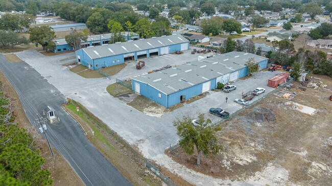
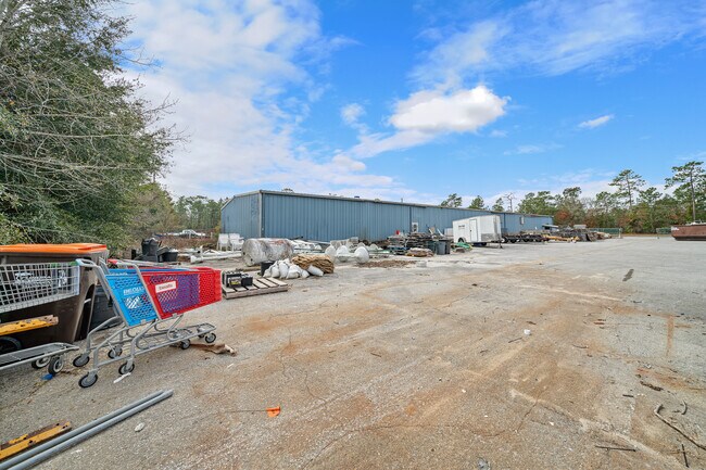
11437 Sw 90Th Ter
Ocala, FL
Oak Run
7000-000-000
SEC 35 TWP 16 RGE 20 BEG AT THE SW COR OF TRACT F OF OAK RUN NIEGHBORHOOD 1 PLAT BOOK X PAGE 100 TH S 00-16-18 W 1168.24 FT MORE OR LESS TO THE N BDY OF HWY 484 TH E TO THE W BDY OF OAK RUN NEIGHBORHOOD 8B PLAT BOOK 1 PAGE 86 TH N 00-16-18 E 1168.24
Warehouse
Marion
AE
Florida
12083C0692E
4
2025
9.13 AC
2025
Outlying Marion County
001008
Ocala
54,028 SF
DEMOGRAPHICS near 11437 Sw 90Th Ter
1 Mile
3 Mile
5 Mile
2024 Total Population
2,113
23,134
56,131
2029 Population
2,306
26,126
64,208
Pop Growth 2024-2029
+ 9.13%
+ 12.93%
+ 14.39%
Average Age
71
62
56
2024 Total Households
1,273
12,190
26,430
HH Growth 2024-2029
+ 9.03%
+ 12.60%
+ 14.08%
Median Household Inc
$46,477
$54,855
$58,779
Avg Household Size
1.60
1.90
2.10
2024 Avg HH Vehicles
1.00
1.00
2.00
Median Home Value
$144,960
$166,433
$198,334
Median Year Built
1988
1995
2000
Nearby Places
Map Layers
Map Styles
 Street
 Aerial
- Restaurants
- Banks
- Shops
- Fitness
- Groceries
SALE & LEASE HISTORY
LISTING DATE
SALE/LEASE

Feb 10, 2025
For Lease
Nearby Properties
Address
Land Use
TOTAL SIZE
Lot Size
Zoning
Address
Land Use
TOTAL SIZE
Lot Size
Zoning
96,094 SF
13.66 AC
B2
Address
Land Use
TOTAL SIZE
Lot Size
Zoning
62,253 SF
6.52 AC
PUD
Address
Land Use
TOTAL SIZE
Lot Size
Zoning
103,410 SF
27.04 AC
PUD
Address
Land Use
TOTAL SIZE
Lot Size
Zoning
74,928 SF
7.80 AC
PUD
Address
Land Use
TOTAL SIZE
Lot Size
Zoning
210,937 SF
27.08 AC
B4
Address
Land Use
TOTAL SIZE
Lot Size
Zoning
3,474.32 AC
A1
Address
Land Use
TOTAL SIZE
Lot Size
Zoning
28,813 SF
70.30 AC
B4
Address
Land Use
TOTAL SIZE
Lot Size
Zoning
18,035 SF
3.33 AC
B2
Address
Land Use
TOTAL SIZE
Lot Size
Zoning
43,619 SF
6.04 AC
R3
Address
Land Use
TOTAL SIZE
Lot Size
Zoning
98,205 SF
13.41 AC
B2
Address
Land Use
TOTAL SIZE
Lot Size
Zoning
88,777 SF
10.50 AC
B4
Address
Land Use
TOTAL SIZE
Lot Size
Zoning
69,278 SF
7.52 AC
B4
Address
Land Use
TOTAL SIZE
Lot Size
Zoning
42,159 SF
5.95 AC
B2
Address
Land Use
TOTAL SIZE
Lot Size
Zoning
68,180 SF
5.40 AC
B5
Address
Land Use
TOTAL SIZE
Lot Size
Zoning
82,904 SF
10.51 AC
B2
Address
Land Use
TOTAL SIZE
Lot Size
Zoning
16,729 SF
5 AC
B4
Address
Land Use
TOTAL SIZE
Lot Size
Zoning
27,563 SF
3.03 AC
B4
Address
Land Use
TOTAL SIZE
Lot Size
Zoning
47,378 SF
23.26 AC
A1
Address
Land Use
TOTAL SIZE
Lot Size
Zoning
286.80 AC
PUD
Address
Land Use
TOTAL SIZE
Lot Size
Zoning
58,381 SF
5.12 AC
R3
Address
Land Use
TOTAL SIZE
Lot Size
Zoning
16,214 SF
4.91 AC
B2
Address
Land Use
TOTAL SIZE
Lot Size
Zoning
37,213 SF
14.54 AC
A1
Address
Land Use
TOTAL SIZE
Lot Size
Zoning
27,862 SF
17.04 AC
A1
Address
Land Use
TOTAL SIZE
Lot Size
Zoning
41,642 SF
5.47 AC
B4
Address
Land Use
TOTAL SIZE
Lot Size
Zoning
20,288 SF
7.20 AC
B2
Address
Land Use
TOTAL SIZE
Lot Size
Zoning
17,428 SF
2.01 AC
B4
Address
Land Use
TOTAL SIZE
Lot Size
Zoning
45,364 SF
6.69 AC
B2
Address
Land Use
TOTAL SIZE
Lot Size
Zoning
955 AC
A1
Address
Land Use
TOTAL SIZE
Lot Size
Zoning
16,308 SF
1.74 AC
B2
Address
Land Use
TOTAL SIZE
Lot Size
Zoning
25,898 SF
4.13 AC
B4
The World's #1 Commercial Real Estate Marketplace
Connect with us
© 2026 CoStar Group
The information above has been obtained from sources believed reliable. While we do not doubt its accuracy we have not verified it and make no guarantee, warranty or representation about it. It is your responsibility to independently confirm its accuracy and completeness. Any projections, opinions, assumptions, or estimates used are for example only and do not represent the current or future performance of the property. The value of this transaction to you depends on tax and other factors which should be evaluated by your tax, financial, and legal advisors. You and your advisors should conduct a careful, independent investigation of the property to determine to your satisfaction the suitability of the property for your needs.