Property Record
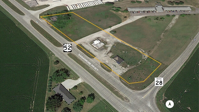
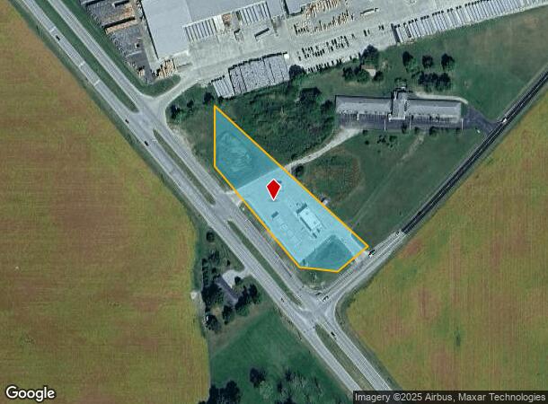
11437 Us Highway 52 S, Clarks Hill, IN 47930
NEARBY LISTINGS FOR SALE OR LEASE
-
-
View all Clarks Hill listings for sale on LoopNet.com
Property Detail
11437 Us Highway 52 S
79-16-24-200-007.000-007
PT NE SEC 24 TWP 21 R3 2.455 A
Commercialacreage
Tippecanoe
X
Indiana
18023C0125C
1
2024
2.46 AC
2024
Lafayette/Kokomo
011000
Other Market Areas
1,320 SF
Lafayette-West Lafayette, IN
DEMOGRAPHICS near 11437 Us Highway 52 S
1 Mile
3 Mile
5 Mile
2024 Total Population
48
1,048
2,957
2029 Population
46
1,001
2,860
Pop Growth 2024-2029
(4.17%)
(4.48%)
(3.28%)
Average Age
40
40
41
2024 Total Households
18
397
1,124
HH Growth 2024-2029
(5.56%)
(4.28%)
(3.20%)
Median Household Inc
$67,500
$59,188
$66,331
Avg Household Size
2.60
2.60
2.60
2024 Avg HH Vehicles
2.00
2.00
2.00
Median Home Value
$162,499
$173,999
$199,230
Median Year Built
1962
1962
1966
Nearby Places
- Restaurants
- Banks
- Shops
- Fitness
- Groceries
SALE & LEASE HISTORY
LISTING DATE
SALE/LEASE

Feb 03, 2020
For Sale
Nearby Properties
Address
Land Use
TOTAL SIZE
Lot Size
Zoning
Address
Land Use
TOTAL SIZE
Lot Size
Zoning
44.01 AC
Address
Land Use
TOTAL SIZE
Lot Size
Zoning
148,525 SF
87 SF
Address
Land Use
TOTAL SIZE
Lot Size
Zoning
285,600 SF
68.25 AC
Address
Land Use
TOTAL SIZE
Lot Size
Zoning
26,534 SF
9.59 AC
Address
Land Use
TOTAL SIZE
Lot Size
Zoning
13,910 SF
10.34 AC
Address
Land Use
TOTAL SIZE
Lot Size
Zoning
0.03 AC
Address
Land Use
TOTAL SIZE
Lot Size
Zoning
1,800 SF
12.33 AC
Address
Land Use
TOTAL SIZE
Lot Size
Zoning
0.03 AC
Address
Land Use
TOTAL SIZE
Lot Size
Zoning
11,584 SF
6.26 AC
Address
Land Use
TOTAL SIZE
Lot Size
Zoning
2,204 SF
0.01 AC
Address
Land Use
TOTAL SIZE
Lot Size
Zoning
4,100 SF
1.15 AC
Address
Land Use
TOTAL SIZE
Lot Size
Zoning
2,772 SF
158.14 AC
Address
Land Use
TOTAL SIZE
Lot Size
Zoning
3,126 SF
0.01 AC
Address
Land Use
TOTAL SIZE
Lot Size
Zoning
5,584 SF
44 SF
Address
Land Use
TOTAL SIZE
Lot Size
Zoning
17,974 SF
44 SF
Address
Land Use
TOTAL SIZE
Lot Size
Zoning
5,490 SF
174 SF
Address
Land Use
TOTAL SIZE
Lot Size
Zoning
0.02 AC
Address
Land Use
TOTAL SIZE
Lot Size
Zoning
3,240 SF
2 AC
Address
Land Use
TOTAL SIZE
Lot Size
Zoning
6,355 SF
174 SF
Address
Land Use
TOTAL SIZE
Lot Size
Zoning
Address
Land Use
TOTAL SIZE
Lot Size
Zoning
4,484 SF
174 SF
Address
Land Use
TOTAL SIZE
Lot Size
Zoning
32.99 AC
Address
Land Use
TOTAL SIZE
Lot Size
Zoning
1,776 SF
0.01 AC
Address
Land Use
TOTAL SIZE
Lot Size
Zoning
1,915 SF
120 AC
Address
Land Use
TOTAL SIZE
Lot Size
Zoning
0.02 AC
Address
Land Use
TOTAL SIZE
Lot Size
Zoning
3,658 SF
0.01 AC
Address
Land Use
TOTAL SIZE
Lot Size
Zoning
2,446 SF
0.01 AC
Address
Land Use
TOTAL SIZE
Lot Size
Zoning
0.99 AC
Address
Land Use
TOTAL SIZE
Lot Size
Zoning
2,233 SF
0.01 AC
The World's #1 Commercial Real Estate Marketplace
Connect with us
© 2025 CoStar Group
The information above has been obtained from sources believed reliable. While we do not doubt its accuracy we have not verified it and make no guarantee, warranty or representation about it. It is your responsibility to independently confirm its accuracy and completeness. Any projections, opinions, assumptions, or estimates used are for example only and do not represent the current or future performance of the property. The value of this transaction to you depends on tax and other factors which should be evaluated by your tax, financial, and legal advisors. You and your advisors should conduct a careful, independent investigation of the property to determine to your satisfaction the suitability of the property for your needs.