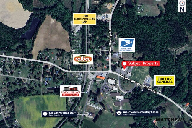
Property Record
1144 Greenwood Rd, Sanford, NC 27332


NEARBY LISTINGS FOR SALE OR LEASE
-
-
View all Sanford listings for sale on LoopNet.com
Property Detail
1144 Greenwood Rd
9549-26-4768-00
Existing Parcel Survey For Cedar Run Cap
Storebuilding
TRACT C PLAT 2017/61
X
Lee
3710954800J
North Carolina
0
1.45 AC
2025
North Carolina Southeast Area
030504
Other Market Areas
8,160 SF
Sanford, NC
DEMOGRAPHICS near 1144 Greenwood Rd
1 Mile
3 Mile
5 Mile
2024 Total Population
612
5,071
23,178
2029 Population
656
5,460
24,977
Pop Growth 2024-2029
+ 7.19%
+ 7.67%
+ 7.76%
Average Age
41
40
39
2024 Total Households
241
1,938
9,091
HH Growth 2024-2029
+ 7.05%
+ 7.69%
+ 7.75%
Median Household Inc
$56,203
$59,205
$59,253
Avg Household Size
2.50
2.60
2.50
2024 Avg HH Vehicles
2.00
2.00
2.00
Median Home Value
$75,925
$138,998
$163,318
Median Year Built
1985
1988
1991
Nearby Places
Map Layers
Map Styles
 Street
 Aerial
- Restaurants
- Banks
- Shops
- Fitness
- Groceries
SALE & LEASE HISTORY
LISTING DATE
SALE/LEASE

May 06, 2025
For Sale
Aug 14, 2018
For Sale
Nearby Properties
Address
Land Use
TOTAL SIZE
Lot Size
Zoning
Address
Land Use
TOTAL SIZE
Lot Size
Zoning
70,498 SF
23.55 AC
RESIDENTIA
Address
Land Use
TOTAL SIZE
Lot Size
Zoning
12,530 SF
19.60 AC
LIGHT INDU
Address
Land Use
TOTAL SIZE
Lot Size
Zoning
2,080 SF
113.74 AC
HEAVY INDU
Address
Land Use
TOTAL SIZE
Lot Size
Zoning
1,104 SF
9.31 AC
Address
Land Use
TOTAL SIZE
Lot Size
Zoning
6,900 SF
8.21 AC
OFFICE & I
Address
Land Use
TOTAL SIZE
Lot Size
Zoning
91.82 AC
HEAVY INDU
Address
Land Use
TOTAL SIZE
Lot Size
Zoning
1,047 SF
234.38 AC
RESIDENTIA
Address
Land Use
TOTAL SIZE
Lot Size
Zoning
13,896 SF
6.07 AC
HIGHWAY CO
Address
Land Use
TOTAL SIZE
Lot Size
Zoning
3,632 SF
40.60 AC
RESIDENTIA
Address
Land Use
TOTAL SIZE
Lot Size
Zoning
871 SF
75.25 AC
RESIDENTIA
Address
Land Use
TOTAL SIZE
Lot Size
Zoning
367.84 AC
RESIDENTIA
Address
Land Use
TOTAL SIZE
Lot Size
Zoning
313.89 AC
RESIDENTIA
Address
Land Use
TOTAL SIZE
Lot Size
Zoning
20.32 AC
HIGHWAY CO
Address
Land Use
TOTAL SIZE
Lot Size
Zoning
25,200 SF
24.10 AC
LIGHT INDU
Address
Land Use
TOTAL SIZE
Lot Size
Zoning
8,320 SF
155.14 AC
RESIDENTIA
Address
Land Use
TOTAL SIZE
Lot Size
Zoning
2,229 SF
8.92 AC
RESIDENTIA
Address
Land Use
TOTAL SIZE
Lot Size
Zoning
9,300 SF
156 AC
RESIDENTIA
Address
Land Use
TOTAL SIZE
Lot Size
Zoning
1,918 SF
281.25 AC
RESIDENTIA
Address
Land Use
TOTAL SIZE
Lot Size
Zoning
3,560 SF
60.53 AC
RESIDENTIA
Address
Land Use
TOTAL SIZE
Lot Size
Zoning
1,041 SF
201.01 AC
RESIDENTIA
Address
Land Use
TOTAL SIZE
Lot Size
Zoning
4,668 SF
17.95 AC
HEAVY INDU
Address
Land Use
TOTAL SIZE
Lot Size
Zoning
10,652 SF
1.95 AC
RESIDENTIA
Address
Land Use
TOTAL SIZE
Lot Size
Zoning
2,520 SF
3.77 AC
HIGHWAY CO
Address
Land Use
TOTAL SIZE
Lot Size
Zoning
69.58 AC
LIGHT INDU
Address
Land Use
TOTAL SIZE
Lot Size
Zoning
3,520 SF
7.77 AC
HEAVY INDU
Address
Land Use
TOTAL SIZE
Lot Size
Zoning
10,953 SF
0.70 AC
RAMH
Address
Land Use
TOTAL SIZE
Lot Size
Zoning
1,057 SF
138.48 AC
RESIDENTIA
Address
Land Use
TOTAL SIZE
Lot Size
Zoning
1,800 SF
131.18 AC
RESIDENTIA
Address
Land Use
TOTAL SIZE
Lot Size
Zoning
9,684 SF
1.10 AC
NC
Address
Land Use
TOTAL SIZE
Lot Size
Zoning
9,748 SF
9.34 AC
RESIDENTIA
The World's #1 Commercial Real Estate Marketplace
Connect with us
© 2026 CoStar Group
The information above has been obtained from sources believed reliable. While we do not doubt its accuracy we have not verified it and make no guarantee, warranty or representation about it. It is your responsibility to independently confirm its accuracy and completeness. Any projections, opinions, assumptions, or estimates used are for example only and do not represent the current or future performance of the property. The value of this transaction to you depends on tax and other factors which should be evaluated by your tax, financial, and legal advisors. You and your advisors should conduct a careful, independent investigation of the property to determine to your satisfaction the suitability of the property for your needs.