Property Record
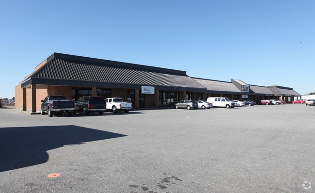
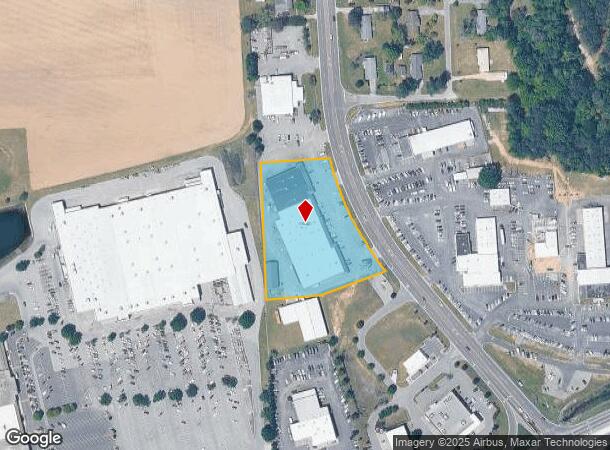
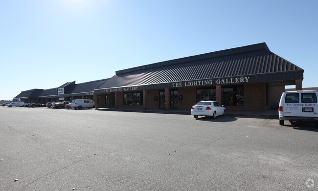
1144 Hwy 258 N, Kinston, NC 28504
NEARBY LISTINGS FOR SALE OR LEASE
Property Detail
1144 Hwy 258 N
450503445186
VILLAGE SQUARE MULTIPLE ADDRESS POINTS
Stripcommercialcenter
Lenoir
X
North Carolina
3720450400K
2.85 AC
2025
North Carolina Southeast Area
2025
Other Market Areas
011001
Kinston, NC
46,975 SF
DEMOGRAPHICS near 1144 Hwy 258 N
1 Mile
3 Mile
5 Mile
2024 Total Population
522
8,272
29,620
2029 Population
518
8,082
29,406
Pop Growth 2024-2029
(0.77%)
(2.30%)
(0.72%)
Average Age
47
44
42
2024 Total Households
198
3,413
12,663
HH Growth 2024-2029
(1.01%)
(2.46%)
(0.70%)
Median Household Inc
$43,958
$48,593
$38,266
Avg Household Size
2.40
2.30
2.20
2024 Avg HH Vehicles
2.00
2.00
2.00
Median Home Value
$137,735
$137,556
$112,673
Median Year Built
1977
1978
1973
Nearby Places
Map Layers
Map Styles
 Street
 Aerial
- Restaurants
- Banks
- Shops
- Fitness
- Groceries
PUBLIC TRANSPORTATION
AIRPORT
Pitt-Greenville
DRIVE
WALK
Distance
Pitt-Greenville
49 min
37.9 mi
Freight Ports
Port of Morehead City
DRIVE
WALK
Distance
Port of Morehead City
112 min
79.0 mi
Nearby Properties
Address
Land Use
TOTAL SIZE
Lot Size
Zoning
Address
Land Use
TOTAL SIZE
Lot Size
Zoning
216,063 SF
354.52 AC
I1
Address
Land Use
TOTAL SIZE
Lot Size
Zoning
22,420 SF
762.37 AC
RA6
Address
Land Use
TOTAL SIZE
Lot Size
Zoning
184,270 SF
980.52 AC
Address
Land Use
TOTAL SIZE
Lot Size
Zoning
99,724 SF
23.40 AC
Address
Land Use
TOTAL SIZE
Lot Size
Zoning
445,987 SF
957.24 AC
I1
Address
Land Use
TOTAL SIZE
Lot Size
Zoning
185,181 SF
12.24 AC
SC
Address
Land Use
TOTAL SIZE
Lot Size
Zoning
525,000 SF
384.32 AC
I1
Address
Land Use
TOTAL SIZE
Lot Size
Zoning
409,695 SF
25 AC
Address
Land Use
TOTAL SIZE
Lot Size
Zoning
8,850 SF
1,328.25 AC
Address
Land Use
TOTAL SIZE
Lot Size
Zoning
107,460 SF
17.70 AC
I2
Address
Land Use
TOTAL SIZE
Lot Size
Zoning
202,946 SF
34.01 AC
I1
Address
Land Use
TOTAL SIZE
Lot Size
Zoning
247,376 SF
99.63 AC
I1
Address
Land Use
TOTAL SIZE
Lot Size
Zoning
64,008 SF
24 AC
I1
Address
Land Use
TOTAL SIZE
Lot Size
Zoning
45,675 SF
2.89 AC
IB
Address
Land Use
TOTAL SIZE
Lot Size
Zoning
118,696 SF
15.62 AC
IB
Address
Land Use
TOTAL SIZE
Lot Size
Zoning
234.71 AC
I1
Address
Land Use
TOTAL SIZE
Lot Size
Zoning
20,748 SF
33.22 AC
B1
Address
Land Use
TOTAL SIZE
Lot Size
Zoning
44,157 SF
25.70 AC
Address
Land Use
TOTAL SIZE
Lot Size
Zoning
424,443 SF
104.04 AC
SC
Address
Land Use
TOTAL SIZE
Lot Size
Zoning
10,900 SF
9.14 AC
SC
Address
Land Use
TOTAL SIZE
Lot Size
Zoning
39,537 SF
1.58 AC
SC
Address
Land Use
TOTAL SIZE
Lot Size
Zoning
78,420 SF
10 AC
I1
Address
Land Use
TOTAL SIZE
Lot Size
Zoning
50,263 SF
11.34 AC
SC
Address
Land Use
TOTAL SIZE
Lot Size
Zoning
14,706 SF
2.62 AC
B1
Address
Land Use
TOTAL SIZE
Lot Size
Zoning
43,545 SF
5.62 AC
SC
Address
Land Use
TOTAL SIZE
Lot Size
Zoning
35,906 SF
4.08 AC
Address
Land Use
TOTAL SIZE
Lot Size
Zoning
27,478 SF
17.52 AC
Address
Land Use
TOTAL SIZE
Lot Size
Zoning
74,734 SF
8.81 AC
RA8
Address
Land Use
TOTAL SIZE
Lot Size
Zoning
39,856 SF
8 AC
Address
Land Use
TOTAL SIZE
Lot Size
Zoning
89.78 AC
RA6
The World's #1 Commercial Real Estate Marketplace
Connect with us
© 2026 CoStar Group
The information above has been obtained from sources believed reliable. While we do not doubt its accuracy we have not verified it and make no guarantee, warranty or representation about it. It is your responsibility to independently confirm its accuracy and completeness. Any projections, opinions, assumptions, or estimates used are for example only and do not represent the current or future performance of the property. The value of this transaction to you depends on tax and other factors which should be evaluated by your tax, financial, and legal advisors. You and your advisors should conduct a careful, independent investigation of the property to determine to your satisfaction the suitability of the property for your needs.