Property Record
11444 Gulf Beach Hwy, Pensacola, FL 32507

NEARBY LISTINGS FOR SALE OR LEASE
Property Detail
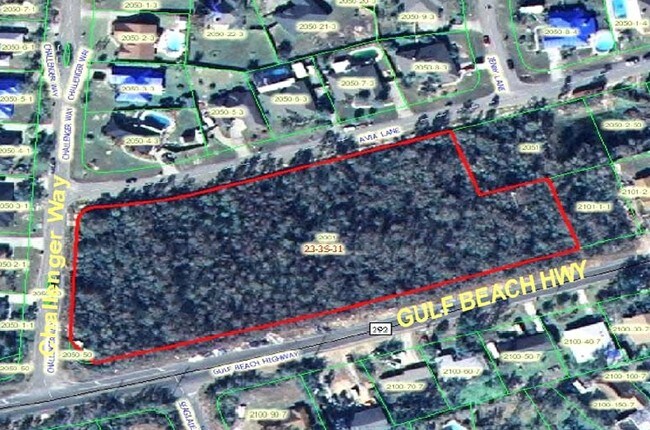
11444 Gulf Beach Hwy
Pensacola-Ferry Pass-Brent, FL
Subdivision Number: 2001
23-3S-31-2001-000-000
BEGIN AT THE SOUTHWEST CORNER OF LOT 1, BLOCK A, A RESUBDIVISION OF THE SECOND ADDITION TO SEAGLADE, AS RECORDED IN PLAT BOOK 6 AT PAGE 79 OF THE PUBLIC RECORDS OF ESCAMBIA COUNTY, FLORIDA, SAID POINT BEING ON THE NORTH RIGHT-OF-WAY LINE OF GULF BEAC
Storemultistory
Escambia
X
Florida
01003C1000M
1
2024
1.80 AC
2025
Perdido
002607
Pensacola
8,763 SF
DEMOGRAPHICS near 11444 Gulf Beach Hwy
1 Mile
3 Mile
5 Mile
2024 Total Population
3,177
12,037
26,004
2029 Population
3,245
12,436
27,382
Pop Growth 2024-2029
+ 2.14%
+ 3.31%
+ 5.30%
Average Age
43
44
43
2024 Total Households
1,241
5,013
11,012
HH Growth 2024-2029
+ 2.26%
+ 3.57%
+ 5.84%
Median Household Inc
$98,179
$87,084
$75,808
Avg Household Size
2.50
2.40
2.30
2024 Avg HH Vehicles
2.00
2.00
2.00
Median Home Value
$288,332
$298,285
$293,446
Median Year Built
1997
1996
1997
Nearby Places
Map Layers
Map Styles
 Street
 Aerial
- Restaurants
- Banks
- Shops
- Fitness
- Groceries
PUBLIC TRANSPORTATION
AIRPORT
Pensacola International
DRIVE
WALK
Distance
Pensacola International
36 min
19.1 mi
Nearby Properties
Address
Land Use
TOTAL SIZE
Lot Size
Zoning
Address
Land Use
TOTAL SIZE
Lot Size
Zoning
124.51 AC
NONE
Address
Land Use
TOTAL SIZE
Lot Size
Zoning
379,293 SF
28.14 AC
COM
Address
Land Use
TOTAL SIZE
Lot Size
Zoning
499.23 AC
NONE
Address
Land Use
TOTAL SIZE
Lot Size
Zoning
3,456 SF
133.13 AC
NONE
Address
Land Use
TOTAL SIZE
Lot Size
Zoning
106.11 AC
NONE
Address
Land Use
TOTAL SIZE
Lot Size
Zoning
193,561 SF
23.31 AC
COM
Address
Land Use
TOTAL SIZE
Lot Size
Zoning
36.04 AC
NONE
Address
Land Use
TOTAL SIZE
Lot Size
Zoning
72.60 AC
NONE
Address
Land Use
TOTAL SIZE
Lot Size
Zoning
153,007 SF
6.34 AC
COM
Address
Land Use
TOTAL SIZE
Lot Size
Zoning
208,596 SF
24.20 AC
COM
Address
Land Use
TOTAL SIZE
Lot Size
Zoning
53.94 AC
NONE
Address
Land Use
TOTAL SIZE
Lot Size
Zoning
20,818 SF
104.24 AC
NONE
Address
Land Use
TOTAL SIZE
Lot Size
Zoning
193,348 SF
29 AC
COM,HDR
Address
Land Use
TOTAL SIZE
Lot Size
Zoning
138,339 SF
57.97 AC
LDR
Address
Land Use
TOTAL SIZE
Lot Size
Zoning
74,290 SF
26.17 AC
MDR
Address
Land Use
TOTAL SIZE
Lot Size
Zoning
27,344 SF
4.85 AC
HC/LI
Address
Land Use
TOTAL SIZE
Lot Size
Zoning
66.90 AC
NONE
Address
Land Use
TOTAL SIZE
Lot Size
Zoning
53,189 SF
6.52 AC
COM
Address
Land Use
TOTAL SIZE
Lot Size
Zoning
61,340 SF
2.15 AC
HC/LI
Address
Land Use
TOTAL SIZE
Lot Size
Zoning
36,960 SF
15.78 AC
COM
Address
Land Use
TOTAL SIZE
Lot Size
Zoning
49,787 SF
7.05 AC
HC/LI
Address
Land Use
TOTAL SIZE
Lot Size
Zoning
100,532 SF
25 AC
HDR
Address
Land Use
TOTAL SIZE
Lot Size
Zoning
43,726 SF
14.35 AC
MDR
Address
Land Use
TOTAL SIZE
Lot Size
Zoning
41,837 SF
16.61 AC
MDR
Address
Land Use
TOTAL SIZE
Lot Size
Zoning
51,504 SF
3.53 AC
HC/LI
Address
Land Use
TOTAL SIZE
Lot Size
Zoning
22,320 SF
2.05 AC
HDMU
Address
Land Use
TOTAL SIZE
Lot Size
Zoning
64,000 SF
4.72 AC
COM
Address
Land Use
TOTAL SIZE
Lot Size
Zoning
24,200 SF
3 AC
COM
Address
Land Use
TOTAL SIZE
Lot Size
Zoning
2,500 SF
32.40 AC
HC/LI
Address
Land Use
TOTAL SIZE
Lot Size
Zoning
13,976 SF
180.60 AC
LDR
The World's #1 Commercial Real Estate Marketplace
Connect with us
© 2026 CoStar Group
The information above has been obtained from sources believed reliable. While we do not doubt its accuracy we have not verified it and make no guarantee, warranty or representation about it. It is your responsibility to independently confirm its accuracy and completeness. Any projections, opinions, assumptions, or estimates used are for example only and do not represent the current or future performance of the property. The value of this transaction to you depends on tax and other factors which should be evaluated by your tax, financial, and legal advisors. You and your advisors should conduct a careful, independent investigation of the property to determine to your satisfaction the suitability of the property for your needs.