Property Record
1145 State Route 33, Farmingdale, NJ 07727
NEARBY LISTINGS FOR SALE OR LEASE
Property Detail
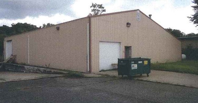
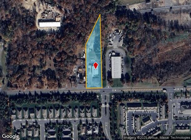
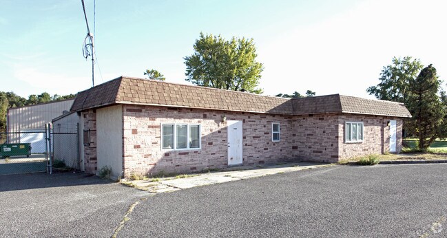
1145 State Route 33
21-00183-0000-00076
Final Map Section 1 Berkshire Land Compa
Storemultistory
Monmouth
X
New Jersey
34025C0310F
76
2024
1.90 AC
2025
Western Monmouth
811102
Northern New Jersey
2,353 SF
New York-Jersey City-White Plains, NY-NJ
DEMOGRAPHICS near 1145 State Route 33
1 Mile
3 Mile
5 Mile
2024 Total Population
1,835
9,380
45,122
2029 Population
1,872
9,370
44,676
Pop Growth 2024-2029
+ 2.02%
(0.11%)
(0.99%)
Average Age
53
43
43
2024 Total Households
812
3,467
17,501
HH Growth 2024-2029
+ 1.97%
(0.09%)
(1.30%)
Median Household Inc
$86,160
$112,375
$109,617
Avg Household Size
2.20
2.60
2.50
2024 Avg HH Vehicles
2.00
2.00
2.00
Median Home Value
$666,132
$634,615
$457,268
Median Year Built
2006
1989
1988
Nearby Places
Map Layers
Map Styles
 Street
 Aerial
- Restaurants
- Banks
- Shops
- Fitness
- Groceries
PUBLIC TRANSPORTATION
COMMUTER RAIL
Bradley Beach (North Jersey Coast Line - NJ Transit Commuter Rail (NJ Transit))
DRIVE
WALK
Distance
Bradley Beach (North Jersey Coast Line - NJ Transit Commuter Rail (NJ Transit))
14 min
9.9 mi
Freight Ports
New York Container Terminal
DRIVE
WALK
Distance
New York Container Terminal
53 min
38.9 mi
Nearby Properties
Address
Land Use
TOTAL SIZE
Lot Size
Zoning
Address
Land Use
TOTAL SIZE
Lot Size
Zoning
3,255.78 AC
ARE6
Address
Land Use
TOTAL SIZE
Lot Size
Zoning
36.48 AC
HD-2
Address
Land Use
TOTAL SIZE
Lot Size
Zoning
152,121 SF
22.16 AC
OR10
Address
Land Use
TOTAL SIZE
Lot Size
Zoning
192,708 SF
33.36 AC
OR10
Address
Land Use
TOTAL SIZE
Lot Size
Zoning
3,040 SF
194.08 AC
OSGS
Address
Land Use
TOTAL SIZE
Lot Size
Zoning
13 AC
R-40
Address
Land Use
TOTAL SIZE
Lot Size
Zoning
1.06 AC
AG
Address
Land Use
TOTAL SIZE
Lot Size
Zoning
120,000 SF
77 AC
ARE2
Address
Land Use
TOTAL SIZE
Lot Size
Zoning
912 SF
201.36 AC
RRC
Address
Land Use
TOTAL SIZE
Lot Size
Zoning
240,362 SF
61.13 AC
ARE6
Address
Land Use
TOTAL SIZE
Lot Size
Zoning
427.37 AC
POS
Address
Land Use
TOTAL SIZE
Lot Size
Zoning
332,213 SF
26.55 AC
OR10
Address
Land Use
TOTAL SIZE
Lot Size
Zoning
647.36 AC
HD03
Address
Land Use
TOTAL SIZE
Lot Size
Zoning
161,000 SF
21.60 AC
ARE2
Address
Land Use
TOTAL SIZE
Lot Size
Zoning
3,474 SF
4.12 AC
OR10
Address
Land Use
TOTAL SIZE
Lot Size
Zoning
79,746 SF
9.06 AC
OR10
Address
Land Use
TOTAL SIZE
Lot Size
Zoning
55,984 SF
16.11 AC
LI
Address
Land Use
TOTAL SIZE
Lot Size
Zoning
10.11 AC
SED
Address
Land Use
TOTAL SIZE
Lot Size
Zoning
91,180 SF
27.20 AC
SED
Address
Land Use
TOTAL SIZE
Lot Size
Zoning
86,936 SF
3.42 AC
LI
Address
Land Use
TOTAL SIZE
Lot Size
Zoning
42.76 AC
SED
Address
Land Use
TOTAL SIZE
Lot Size
Zoning
33,128 SF
12.68 AC
ARE6
Address
Land Use
TOTAL SIZE
Lot Size
Zoning
13.33 AC
SED
Address
Land Use
TOTAL SIZE
Lot Size
Zoning
7.04 AC
SED
Address
Land Use
TOTAL SIZE
Lot Size
Zoning
6.24 AC
SED
Address
Land Use
TOTAL SIZE
Lot Size
Zoning
53,480 SF
5.08 AC
OR10
Address
Land Use
TOTAL SIZE
Lot Size
Zoning
174.77 AC
POS
Address
Land Use
TOTAL SIZE
Lot Size
Zoning
95,054 SF
11.83 AC
CR10
Address
Land Use
TOTAL SIZE
Lot Size
Zoning
19,990 SF
8.87 AC
OR10
Address
Land Use
TOTAL SIZE
Lot Size
Zoning
18.19 AC
ML-7
The World's #1 Commercial Real Estate Marketplace
Connect with us
© 2025 CoStar Group
The information above has been obtained from sources believed reliable. While we do not doubt its accuracy we have not verified it and make no guarantee, warranty or representation about it. It is your responsibility to independently confirm its accuracy and completeness. Any projections, opinions, assumptions, or estimates used are for example only and do not represent the current or future performance of the property. The value of this transaction to you depends on tax and other factors which should be evaluated by your tax, financial, and legal advisors. You and your advisors should conduct a careful, independent investigation of the property to determine to your satisfaction the suitability of the property for your needs.