Property Record
1147 Farrs Bridge Rd, Pickens, SC 29671
NEARBY LISTINGS FOR SALE OR LEASE
-
-
View all Pickens listings for sale on LoopNet.com
Property Detail
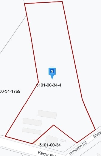
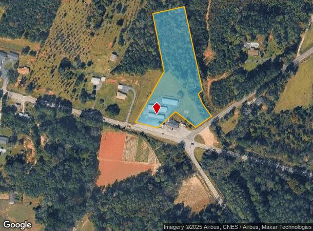
1147 Farrs Bridge Rd
5101-00-34-4831
Survey For Barry J Herd & Rhonda G Herd
Publicstorage
NE/SIDE FARRS BRIDGE RD NW/SIDE JAMESON RD PLAT 617/239
X
Pickens
45077C0170D
South Carolina
2025
4.40 AC
2024
Outlying Pickens Co
010405
Greenville/Spartanburg
3,000 SF
Greenville-Anderson-Mauldin, SC
DEMOGRAPHICS near 1147 Farrs Bridge Rd
1 Mile
3 Mile
5 Mile
2024 Total Population
693
9,389
28,655
2029 Population
726
9,821
30,011
Pop Growth 2024-2029
+ 4.76%
+ 4.60%
+ 4.73%
Average Age
42
42
41
2024 Total Households
266
3,641
11,388
HH Growth 2024-2029
+ 4.51%
+ 4.70%
+ 4.83%
Median Household Inc
$38,552
$41,884
$48,447
Avg Household Size
2.50
2.50
2.40
2024 Avg HH Vehicles
2.00
2.00
2.00
Median Home Value
$130,769
$160,519
$164,528
Median Year Built
1983
1982
1983
Nearby Places
Map Layers
Map Styles
 Street
 Aerial
- Restaurants
- Banks
- Shops
- Fitness
- Groceries
PUBLIC TRANSPORTATION
AIRPORT
Greenville Spartanburg International
DRIVE
WALK
Distance
Greenville Spartanburg International
49 min
30.2 mi
Freight Ports
North Charleston Terminal
DRIVE
WALK
Distance
North Charleston Terminal
256 min
220.9 mi
Nearby Properties
Address
Land Use
TOTAL SIZE
Lot Size
Zoning
Address
Land Use
TOTAL SIZE
Lot Size
Zoning
56,599 SF
8.02 AC
RM16
Address
Land Use
TOTAL SIZE
Lot Size
Zoning
29,595 SF
2.94 AC
R12
Address
Land Use
TOTAL SIZE
Lot Size
Zoning
5,356 SF
17.33 AC
Address
Land Use
TOTAL SIZE
Lot Size
Zoning
27,700 SF
12.91 AC
Address
Land Use
TOTAL SIZE
Lot Size
Zoning
12,466 SF
2.32 AC
R12
Address
Land Use
TOTAL SIZE
Lot Size
Zoning
4,829 SF
2 AC
Address
Land Use
TOTAL SIZE
Lot Size
Zoning
5,645 SF
0.67 AC
Address
Land Use
TOTAL SIZE
Lot Size
Zoning
6,070 SF
1.71 AC
CBD
Address
Land Use
TOTAL SIZE
Lot Size
Zoning
2,679 SF
0.58 AC
Address
Land Use
TOTAL SIZE
Lot Size
Zoning
5,468 SF
0.75 AC
CBD
Address
Land Use
TOTAL SIZE
Lot Size
Zoning
91,940 SF
15.07 AC
GBD
Address
Land Use
TOTAL SIZE
Lot Size
Zoning
20,652 SF
3.89 AC
Address
Land Use
TOTAL SIZE
Lot Size
Zoning
1,056 SF
34.54 AC
R12
Address
Land Use
TOTAL SIZE
Lot Size
Zoning
2,766 SF
0.78 AC
CBD
Address
Land Use
TOTAL SIZE
Lot Size
Zoning
1,296 SF
11.05 AC
Address
Land Use
TOTAL SIZE
Lot Size
Zoning
5,400 SF
2.20 AC
GBD
Address
Land Use
TOTAL SIZE
Lot Size
Zoning
2,997 SF
1.50 AC
GBD
Address
Land Use
TOTAL SIZE
Lot Size
Zoning
4,140 SF
0.06 AC
CBD
Address
Land Use
TOTAL SIZE
Lot Size
Zoning
32,181 SF
2.90 AC
GBD
Address
Land Use
TOTAL SIZE
Lot Size
Zoning
1,716 SF
1.01 AC
GBD
Address
Land Use
TOTAL SIZE
Lot Size
Zoning
1,514 SF
0.34 AC
Address
Land Use
TOTAL SIZE
Lot Size
Zoning
14,461 SF
2.48 AC
GBD
Address
Land Use
TOTAL SIZE
Lot Size
Zoning
29,565 SF
1.86 AC
GBD
Address
Land Use
TOTAL SIZE
Lot Size
Zoning
37,388 SF
4.29 AC
RM16
Address
Land Use
TOTAL SIZE
Lot Size
Zoning
5,876 SF
2.15 AC
R12
Address
Land Use
TOTAL SIZE
Lot Size
Zoning
19.53 AC
Address
Land Use
TOTAL SIZE
Lot Size
Zoning
63,529 SF
7.11 AC
GBD
Address
Land Use
TOTAL SIZE
Lot Size
Zoning
9,917 SF
1.45 AC
GBD
Address
Land Use
TOTAL SIZE
Lot Size
Zoning
14,461 SF
0.41 AC
GBD
Address
Land Use
TOTAL SIZE
Lot Size
Zoning
23.23 AC
R12
The World's #1 Commercial Real Estate Marketplace
Connect with us
© 2026 CoStar Group
The information above has been obtained from sources believed reliable. While we do not doubt its accuracy we have not verified it and make no guarantee, warranty or representation about it. It is your responsibility to independently confirm its accuracy and completeness. Any projections, opinions, assumptions, or estimates used are for example only and do not represent the current or future performance of the property. The value of this transaction to you depends on tax and other factors which should be evaluated by your tax, financial, and legal advisors. You and your advisors should conduct a careful, independent investigation of the property to determine to your satisfaction the suitability of the property for your needs.