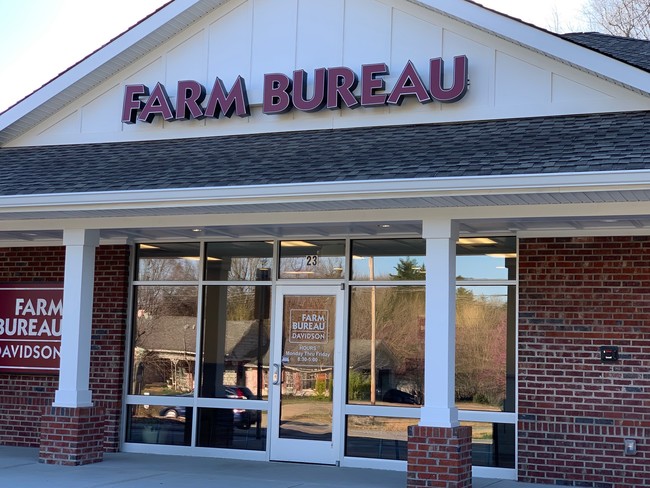
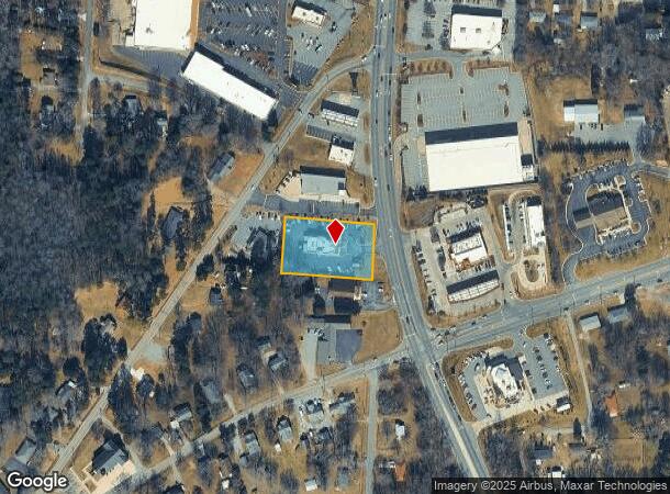
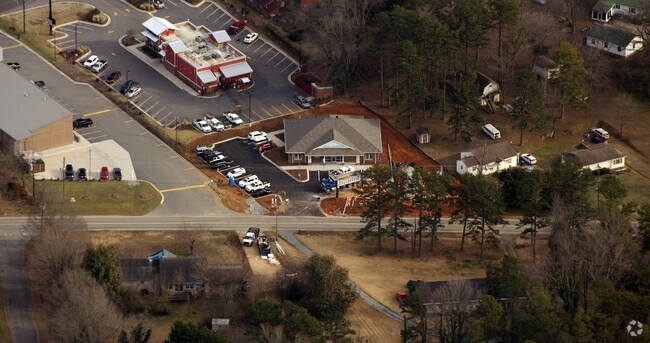
Property Record
1148 Randolph St, Thomasville, NC 27360
NEARBY LISTINGS FOR SALE OR LEASE
Property Detail
1148 Randolph St
16-337-A-000-0012-0-0-0
Plat For 13990 Hwy 19 Llc
Restaurantdrivein
PB70-45 L12 BK2172-1840 TR 1
X
Davidson
3710678600K
North Carolina
2025
0.91 AC
2025
North Davidson County
061101
Greensboro/Winston-Salem
5,179 SF
Winston-Salem, NC
DEMOGRAPHICS near 1148 Randolph St
1 Mile
3 Mile
5 Mile
2024 Total Population
2,933
31,135
50,013
2029 Population
3,085
32,886
52,676
Pop Growth 2024-2029
+ 5.18%
+ 5.62%
+ 5.32%
Average Age
42
41
41
2024 Total Households
1,188
12,500
20,001
HH Growth 2024-2029
+ 5.05%
+ 5.54%
+ 5.23%
Median Household Inc
$47,019
$48,810
$51,992
Avg Household Size
2.40
2.40
2.40
2024 Avg HH Vehicles
2.00
2.00
2.00
Median Home Value
$160,282
$155,307
$157,596
Median Year Built
1984
1978
1980
Nearby Places
Map Layers
Map Styles
 Street
 Aerial
- Restaurants
- Banks
- Shops
- Fitness
- Groceries
PUBLIC TRANSPORTATION
AIRPORT
Piedmont Triad International
DRIVE
WALK
Distance
Piedmont Triad International
38 min
28.1 mi
Freight Ports
Port of Wilmington
DRIVE
WALK
Distance
Port of Wilmington
251 min
208.1 mi
SALE & LEASE HISTORY
LISTING DATE
SALE/LEASE

Apr 05, 2019
For Sale
Nearby Properties
Address
Land Use
TOTAL SIZE
Lot Size
Zoning
Address
Land Use
TOTAL SIZE
Lot Size
Zoning
154,870 SF
62.93 AC
M1
Address
Land Use
TOTAL SIZE
Lot Size
Zoning
103,482 SF
49.98 AC
OI
Address
Land Use
TOTAL SIZE
Lot Size
Zoning
66,674 SF
59.96 AC
OI
Address
Land Use
TOTAL SIZE
Lot Size
Zoning
194,644 SF
20 AC
R10
Address
Land Use
TOTAL SIZE
Lot Size
Zoning
3,638 SF
41.44 AC
OI
Address
Land Use
TOTAL SIZE
Lot Size
Zoning
235,230 SF
25.63 AC
C3
Address
Land Use
TOTAL SIZE
Lot Size
Zoning
134,369 SF
20.67 AC
R15
Address
Land Use
TOTAL SIZE
Lot Size
Zoning
13,770 SF
34.64 AC
R10
Address
Land Use
TOTAL SIZE
Lot Size
Zoning
122,865 SF
30.57 AC
R15
Address
Land Use
TOTAL SIZE
Lot Size
Zoning
9,020 SF
135.18 AC
M1CZ
Address
Land Use
TOTAL SIZE
Lot Size
Zoning
51,230 SF
7.52 AC
C2
Address
Land Use
TOTAL SIZE
Lot Size
Zoning
56,305 SF
5.39 AC
OI
Address
Land Use
TOTAL SIZE
Lot Size
Zoning
12,536 SF
300.20 AC
M1CZ
Address
Land Use
TOTAL SIZE
Lot Size
Zoning
4,224 SF
50.07 AC
M2
Address
Land Use
TOTAL SIZE
Lot Size
Zoning
72,642 SF
10.53 AC
R10
Address
Land Use
TOTAL SIZE
Lot Size
Zoning
124,326 SF
13.45 AC
C3
Address
Land Use
TOTAL SIZE
Lot Size
Zoning
60,183 SF
8.63 AC
C-2
Address
Land Use
TOTAL SIZE
Lot Size
Zoning
127,280 SF
29.10 AC
LI-CZ
Address
Land Use
TOTAL SIZE
Lot Size
Zoning
149,129 SF
15.65 AC
R10
Address
Land Use
TOTAL SIZE
Lot Size
Zoning
44,432 SF
22.13 AC
R10
Address
Land Use
TOTAL SIZE
Lot Size
Zoning
6,960 SF
9.61 AC
R8
Address
Land Use
TOTAL SIZE
Lot Size
Zoning
63,643 SF
8.46 AC
M1
Address
Land Use
TOTAL SIZE
Lot Size
Zoning
162,000 SF
10.67 AC
M1
Address
Land Use
TOTAL SIZE
Lot Size
Zoning
52,466 SF
3.57 AC
C2
Address
Land Use
TOTAL SIZE
Lot Size
Zoning
39,842 SF
12.49 AC
M2
Address
Land Use
TOTAL SIZE
Lot Size
Zoning
35,582 SF
4.95 AC
R8
Address
Land Use
TOTAL SIZE
Lot Size
Zoning
2,460 SF
26.64 AC
R8
Address
Land Use
TOTAL SIZE
Lot Size
Zoning
44,862 SF
4.38 AC
C3
Address
Land Use
TOTAL SIZE
Lot Size
Zoning
42,262 SF
6.73 AC
M1
Address
Land Use
TOTAL SIZE
Lot Size
Zoning
114,220 SF
69.22 AC
M1
The World's #1 Commercial Real Estate Marketplace
Connect with us
© 2026 CoStar Group
The information above has been obtained from sources believed reliable. While we do not doubt its accuracy we have not verified it and make no guarantee, warranty or representation about it. It is your responsibility to independently confirm its accuracy and completeness. Any projections, opinions, assumptions, or estimates used are for example only and do not represent the current or future performance of the property. The value of this transaction to you depends on tax and other factors which should be evaluated by your tax, financial, and legal advisors. You and your advisors should conduct a careful, independent investigation of the property to determine to your satisfaction the suitability of the property for your needs.