Property Record
11485 N 136Th St, Scottsdale, AZ 85259


Current Lease Availabilities
NEARBY LISTINGS FOR SALE OR LEASE
Property Detail
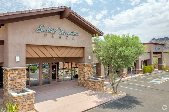
11485 N 136Th St
Phoenix-Mesa-Scottsdale, AZ
Shops C At Saddle Mountain Plaza
217-69-040
SHOPS C AT SADDLE MOUNTAIN PLAZA MCR 644-20
Storebuilding
Maricopa
X
Arizona
04013C1785L
1
2025
1.47 AC
2025
North Scottsdale
216859
Phoenix
12,480 SF
DEMOGRAPHICS near 11485 N 136Th St
1 Mile
3 Mile
5 Mile
2024 Total Population
4,344
24,692
70,259
2029 Population
4,743
27,011
76,916
Pop Growth 2024-2029
+ 9.19%
+ 9.39%
+ 9.47%
Average Age
49
50
50
2024 Total Households
1,729
10,774
31,290
HH Growth 2024-2029
+ 9.25%
+ 9.48%
+ 9.72%
Median Household Inc
$173,760
$129,335
$112,613
Avg Household Size
2.50
2.30
2.20
2024 Avg HH Vehicles
2.00
2.00
2.00
Median Home Value
$810,296
$784,889
$707,870
Median Year Built
1999
1995
1992
Nearby Places
Map Layers
Map Styles
 Street
 Aerial
- Restaurants
- Banks
- Shops
- Fitness
- Groceries
PUBLIC TRANSPORTATION
AIRPORT
Phoenix Sky Harbor International
DRIVE
WALK
Distance
Phoenix Sky Harbor International
36 min
24.0 mi
Phoenix-Mesa Gateway
DRIVE
WALK
Distance
Phoenix-Mesa Gateway
53 min
33.5 mi
Nearby Properties
Address
Land Use
TOTAL SIZE
Lot Size
Zoning
Address
Land Use
TOTAL SIZE
Lot Size
Zoning
582,125 SF
74.02 AC
R-43
Address
Land Use
TOTAL SIZE
Lot Size
Zoning
701,903 SF
35.56 AC
C-T
Address
Land Use
TOTAL SIZE
Lot Size
Zoning
206,966 SF
6 AC
C-T
Address
Land Use
TOTAL SIZE
Lot Size
Zoning
292,054 SF
13.87 AC
M-H
Address
Land Use
TOTAL SIZE
Lot Size
Zoning
42,442 SF
8.01 AC
M-H
Address
Land Use
TOTAL SIZE
Lot Size
Zoning
220,863 SF
11.50 AC
M-H
Address
Land Use
TOTAL SIZE
Lot Size
Zoning
247,990 SF
3.83 AC
M-H
Address
Land Use
TOTAL SIZE
Lot Size
Zoning
142,893 SF
6.09 AC
M-H
Address
Land Use
TOTAL SIZE
Lot Size
Zoning
165,002 SF
8.71 AC
M-H
Address
Land Use
TOTAL SIZE
Lot Size
Zoning
60,922 SF
8.94 AC
R-43
Address
Land Use
TOTAL SIZE
Lot Size
Zoning
192,752 SF
9.30 AC
M-H
Address
Land Use
TOTAL SIZE
Lot Size
Zoning
70,733 SF
8.18 AC
R-10
Address
Land Use
TOTAL SIZE
Lot Size
Zoning
33.56 AC
C-T
Address
Land Use
TOTAL SIZE
Lot Size
Zoning
156,724 SF
8.11 AC
M-H
Address
Land Use
TOTAL SIZE
Lot Size
Zoning
127,975 SF
6.83 AC
C4
Address
Land Use
TOTAL SIZE
Lot Size
Zoning
46,129 SF
6.75 AC
C-R
Address
Land Use
TOTAL SIZE
Lot Size
Zoning
54,368 SF
5.46 AC
C-N
Address
Land Use
TOTAL SIZE
Lot Size
Zoning
35,915 SF
3.45 AC
S-R
Address
Land Use
TOTAL SIZE
Lot Size
Zoning
31,470 SF
8.03 AC
R143
Address
Land Use
TOTAL SIZE
Lot Size
Zoning
74,630 SF
6.67 AC
C-T
Address
Land Use
TOTAL SIZE
Lot Size
Zoning
58,836 SF
5.07 AC
C-R
Address
Land Use
TOTAL SIZE
Lot Size
Zoning
43,170 SF
17.48 AC
RT
Address
Land Use
TOTAL SIZE
Lot Size
Zoning
107,646 SF
3.44 AC
C-R
Address
Land Use
TOTAL SIZE
Lot Size
Zoning
71,070 SF
3.79 AC
C1
Address
Land Use
TOTAL SIZE
Lot Size
Zoning
27,262 SF
5.88 AC
R-6
Address
Land Use
TOTAL SIZE
Lot Size
Zoning
71,055 SF
5 AC
R-43
Address
Land Use
TOTAL SIZE
Lot Size
Zoning
20,728 SF
4.99 AC
R-43
Address
Land Use
TOTAL SIZE
Lot Size
Zoning
29,054 SF
83.81 AC
OS
Address
Land Use
TOTAL SIZE
Lot Size
Zoning
46,059 SF
2.89 AC
C-R
Address
Land Use
TOTAL SIZE
Lot Size
Zoning
37,171 SF
4 AC
C-N
The World's #1 Commercial Real Estate Marketplace
Connect with us
© 2026 CoStar Group
The information above has been obtained from sources believed reliable. While we do not doubt its accuracy we have not verified it and make no guarantee, warranty or representation about it. It is your responsibility to independently confirm its accuracy and completeness. Any projections, opinions, assumptions, or estimates used are for example only and do not represent the current or future performance of the property. The value of this transaction to you depends on tax and other factors which should be evaluated by your tax, financial, and legal advisors. You and your advisors should conduct a careful, independent investigation of the property to determine to your satisfaction the suitability of the property for your needs.