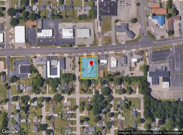
Property Record
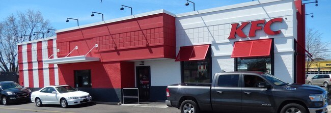
1149 Columbia Ave W, Battle Creek, MI 49015

NEARBY LISTINGS FOR SALE OR LEASE
Property Detail
1149 Columbia Ave W
0065-00-890-0
Parrotts Add
Restaurantdrivein
SEC 15 T2S R8W COMM AT E 1/4 POST OF SEC 15 - N 88 DEG 58 MIN W ALONG E & W 1/4 LINE OF SAID SEC 628.40 FT - S 00 DEG 22 MIN
X
Calhoun
26025C0186C
Michigan
0
0.78 AC
2025
Battle Crk/W Calhoun Cnty
001500
West Michigan
2,585 SF
Battle Creek, MI
DEMOGRAPHICS near 1149 Columbia Ave W
1 Mile
3 Mile
5 Mile
2024 Total Population
7,137
36,437
73,657
2029 Population
7,025
36,106
72,982
Pop Growth 2024-2029
(1.57%)
(0.91%)
(0.92%)
Average Age
39
39
39
2024 Total Households
2,890
14,379
30,182
HH Growth 2024-2029
(1.56%)
(0.94%)
(0.94%)
Median Household Inc
$59,270
$52,000
$48,593
Avg Household Size
2.40
2.40
2.30
2024 Avg HH Vehicles
2.00
2.00
2.00
Median Home Value
$118,936
$124,201
$116,532
Median Year Built
1952
1955
1958
Nearby Places
Map Layers
Map Styles
 Street
 Aerial
- Restaurants
- Banks
- Shops
- Fitness
- Groceries
PUBLIC TRANSPORTATION
COMMUTER RAIL
DRIVE
WALK
Distance
7 min
3.0 mi
AIRPORT
Kalamazoo/Battle Creek International
DRIVE
WALK
Distance
Kalamazoo/Battle Creek International
31 min
20.6 mi
SALE & LEASE HISTORY
LISTING DATE
SALE/LEASE

Apr 30, 2019
For Sale
Nearby Properties
Address
Land Use
TOTAL SIZE
Lot Size
Zoning
Address
Land Use
TOTAL SIZE
Lot Size
Zoning
337,297 SF
18.85 AC
T4
Address
Land Use
TOTAL SIZE
Lot Size
Zoning
291,206 SF
18.98 AC
T4
Address
Land Use
TOTAL SIZE
Lot Size
Zoning
158,242 SF
28.01 AC
B1
Address
Land Use
TOTAL SIZE
Lot Size
Zoning
174,064 SF
T4
Address
Land Use
TOTAL SIZE
Lot Size
Zoning
131,048 SF
12.28 AC
R1A
Address
Land Use
TOTAL SIZE
Lot Size
Zoning
415,320 SF
50.04 AC
I2
Address
Land Use
TOTAL SIZE
Lot Size
Zoning
111,002 SF
AG
Address
Land Use
TOTAL SIZE
Lot Size
Zoning
134,482 SF
17.15 AC
MFR
Address
Land Use
TOTAL SIZE
Lot Size
Zoning
158,242 SF
25.25 AC
B1
Address
Land Use
TOTAL SIZE
Lot Size
Zoning
134,355 SF
5.35 AC
MFR
Address
Land Use
TOTAL SIZE
Lot Size
Zoning
308,395 SF
24.34 AC
I2
Address
Land Use
TOTAL SIZE
Lot Size
Zoning
150,018 SF
13.12 AC
MFR
Address
Land Use
TOTAL SIZE
Lot Size
Zoning
129,598 SF
0.62 AC
T5
Address
Land Use
TOTAL SIZE
Lot Size
Zoning
34,452 SF
1.12 AC
T4
Address
Land Use
TOTAL SIZE
Lot Size
Zoning
106,703 SF
9.69 AC
MFR
Address
Land Use
TOTAL SIZE
Lot Size
Zoning
366,290 SF
31.87 AC
B2
Address
Land Use
TOTAL SIZE
Lot Size
Zoning
94,222 SF
I2
Address
Land Use
TOTAL SIZE
Lot Size
Zoning
49,412 SF
Address
Land Use
TOTAL SIZE
Lot Size
Zoning
188,388 SF
18.15 AC
T3
Address
Land Use
TOTAL SIZE
Lot Size
Zoning
111,744 SF
9.75 AC
RM-1
Address
Land Use
TOTAL SIZE
Lot Size
Zoning
95,666 SF
46.56 AC
I1
Address
Land Use
TOTAL SIZE
Lot Size
Zoning
123,918 SF
24.50 AC
I2
Address
Land Use
TOTAL SIZE
Lot Size
Zoning
41,310 SF
3.53 AC
B2
Address
Land Use
TOTAL SIZE
Lot Size
Zoning
53,501 SF
7.34 AC
B1
Address
Land Use
TOTAL SIZE
Lot Size
Zoning
98,360 SF
0.31 AC
T5
Address
Land Use
TOTAL SIZE
Lot Size
Zoning
50,000 SF
8.48 AC
R-2
Address
Land Use
TOTAL SIZE
Lot Size
Zoning
30,463 SF
1.43 AC
B2
Address
Land Use
TOTAL SIZE
Lot Size
Zoning
82,210 SF
0.29 AC
T5
Address
Land Use
TOTAL SIZE
Lot Size
Zoning
149,939 SF
28.09 AC
I1
Address
Land Use
TOTAL SIZE
Lot Size
Zoning
38,577 SF
4.87 AC
T3
The World's #1 Commercial Real Estate Marketplace
Connect with us
© 2025 CoStar Group
The information above has been obtained from sources believed reliable. While we do not doubt its accuracy we have not verified it and make no guarantee, warranty or representation about it. It is your responsibility to independently confirm its accuracy and completeness. Any projections, opinions, assumptions, or estimates used are for example only and do not represent the current or future performance of the property. The value of this transaction to you depends on tax and other factors which should be evaluated by your tax, financial, and legal advisors. You and your advisors should conduct a careful, independent investigation of the property to determine to your satisfaction the suitability of the property for your needs.