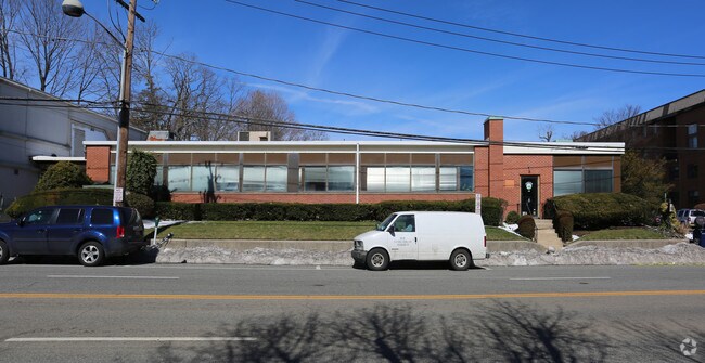
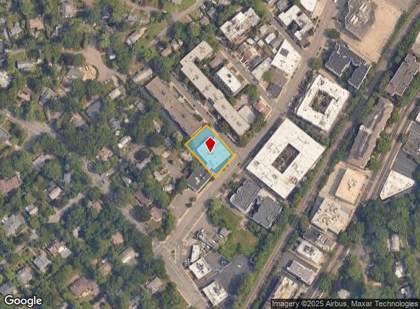
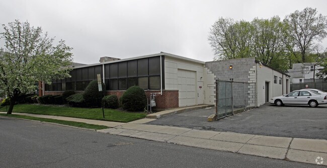
Property Record
115 Cuttermill Rd, Great Neck, NY 11021
NEARBY LISTINGS FOR SALE OR LEASE
Property Detail
115 Cuttermill Rd
2213-02-040-01-0006-0
6,341,342
Officebuilding
Nassau
X
New York
36059C0111G
6
2025
0.52 AC
2025
Western Nassau
300500
Long Island (New York)
11,312 SF
Nassau County-Suffolk County, NY
DEMOGRAPHICS near 115 Cuttermill Rd
1 Mile
3 Mile
5 Mile
2024 Total Population
27,028
159,641
576,163
2029 Population
26,745
152,999
547,544
Pop Growth 2024-2029
(1.05%)
(4.16%)
(4.97%)
Average Age
44
45
44
2024 Total Households
10,571
59,740
200,486
HH Growth 2024-2029
(1.00%)
(4.51%)
(5.30%)
Median Household Inc
$112,257
$106,158
$96,327
Avg Household Size
2.50
2.60
2.80
2024 Avg HH Vehicles
1.00
1.00
1.00
Median Home Value
$869,720
$836,933
$775,239
Median Year Built
1953
1957
1954
Nearby Places
Map Layers
Map Styles
 Street
 Aerial
- Restaurants
- Banks
- Shops
- Fitness
- Groceries
PUBLIC TRANSPORTATION
COMMUTER RAIL
Great Neck Station (Port Washington Branch - Long Island Rail Road)
DRIVE
WALK
Distance
Great Neck Station (Port Washington Branch - Long Island Rail Road)
1 min
10 min
0.5 mi
Little Neck Station (Port Washington Branch - Long Island Rail Road)
DRIVE
WALK
Distance
Little Neck Station (Port Washington Branch - Long Island Rail Road)
4 min
1.6 mi
AIRPORT
LaGuardia
DRIVE
WALK
Distance
LaGuardia
20 min
11.4 mi
John F Kennedy International
DRIVE
WALK
Distance
John F Kennedy International
24 min
15.1 mi
Westchester County
DRIVE
WALK
Distance
Westchester County
48 min
30.7 mi
Freight Ports
NY - Red Hook Container Terminal
DRIVE
WALK
Distance
NY - Red Hook Container Terminal
31 min
19.5 mi
Nearby Properties
Address
Land Use
TOTAL SIZE
Lot Size
Zoning
Address
Land Use
TOTAL SIZE
Lot Size
Zoning
2,697,663 SF
3.46 AC
C5-3
Address
Land Use
TOTAL SIZE
Lot Size
Zoning
1,666,696 SF
1.87 AC
C52.5
Address
Land Use
TOTAL SIZE
Lot Size
Zoning
7,975 SF
133 AC
PARK
Address
Land Use
TOTAL SIZE
Lot Size
Zoning
1,667,567 SF
30 AC
R3-2
Address
Land Use
TOTAL SIZE
Lot Size
Zoning
878,386 SF
20.55 AC
R4
Address
Land Use
TOTAL SIZE
Lot Size
Zoning
421,996 SF
136.05 AC
R3-1
Address
Land Use
TOTAL SIZE
Lot Size
Zoning
4,050 SF
113.40 AC
PARK
Address
Land Use
TOTAL SIZE
Lot Size
Zoning
202,459 SF
82.16 AC
R3-2
Address
Land Use
TOTAL SIZE
Lot Size
Zoning
448,500 SF
22.59 AC
R3-2
Address
Land Use
TOTAL SIZE
Lot Size
Zoning
900 SF
86.35 AC
PARK
Address
Land Use
TOTAL SIZE
Lot Size
Zoning
511,684 SF
13.09 AC
R4
Address
Land Use
TOTAL SIZE
Lot Size
Zoning
198,298 SF
13.93 AC
C4-1
Address
Land Use
TOTAL SIZE
Lot Size
Zoning
186,843 SF
5.37 AC
R2A
Address
Land Use
TOTAL SIZE
Lot Size
Zoning
1,800 SF
54.60 AC
PARK
Address
Land Use
TOTAL SIZE
Lot Size
Zoning
201,770 SF
7.09 AC
R3-2
Address
Land Use
TOTAL SIZE
Lot Size
Zoning
268,500 SF
27.50 AC
R4
Address
Land Use
TOTAL SIZE
Lot Size
Zoning
382,302 SF
6.23 AC
R2A
Address
Land Use
TOTAL SIZE
Lot Size
Zoning
32,000 SF
50 AC
PARK
Address
Land Use
TOTAL SIZE
Lot Size
Zoning
344,292 SF
12.56 AC
R4
Address
Land Use
TOTAL SIZE
Lot Size
Zoning
95.36 AC
PARK
Address
Land Use
TOTAL SIZE
Lot Size
Zoning
111,122 SF
8.94 AC
R3-2
Address
Land Use
TOTAL SIZE
Lot Size
Zoning
123,832 SF
5.29 AC
R3-2
Address
Land Use
TOTAL SIZE
Lot Size
Zoning
231,865 SF
9.99 AC
C4-1
Address
Land Use
TOTAL SIZE
Lot Size
Zoning
356,093 SF
3 AC
R3-2
Address
Land Use
TOTAL SIZE
Lot Size
Zoning
135,000 SF
4.17 AC
R3A
Address
Land Use
TOTAL SIZE
Lot Size
Zoning
107,290 SF
8.66 AC
C4-1
Address
Land Use
TOTAL SIZE
Lot Size
Zoning
11.30 AC
PARK
Address
Land Use
TOTAL SIZE
Lot Size
Zoning
142,000 SF
2.38 AC
R3-2
Address
Land Use
TOTAL SIZE
Lot Size
Zoning
146,081 SF
2.39 AC
R5
Address
Land Use
TOTAL SIZE
Lot Size
Zoning
161,500 SF
3.44 AC
R3-2
The World's #1 Commercial Real Estate Marketplace
Connect with us
© 2026 CoStar Group
The information above has been obtained from sources believed reliable. While we do not doubt its accuracy we have not verified it and make no guarantee, warranty or representation about it. It is your responsibility to independently confirm its accuracy and completeness. Any projections, opinions, assumptions, or estimates used are for example only and do not represent the current or future performance of the property. The value of this transaction to you depends on tax and other factors which should be evaluated by your tax, financial, and legal advisors. You and your advisors should conduct a careful, independent investigation of the property to determine to your satisfaction the suitability of the property for your needs.