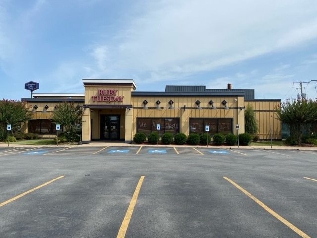
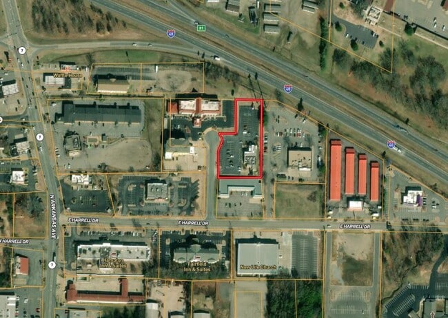
Property Record
115 E Harrell Dr, Russellville, AR 72802

Current Lease Availabilities
Property Detail
115 E Harrell Dr
Russellville, AR
LOT 5A REPLAT CITY OF RUSSELLVILLE
868-80005-000C
Pope
Restaurantbuilding
Arkansas
B and X Area of moderate flood hazard, usually the area between the limits of the 100-year and 500-year floods.
5a
2024
1.51 AC
2025
Fort Smith/Russellville I-40
951303
Other Market Areas
5,135 SF
NEARBY LISTINGS FOR SALE OR LEASE
DEMOGRAPHICS near 115 E Harrell Dr
1 mile
3 mile
5 mile
2025 Total Population
3,684
26,124
36,728
2030 Population
3,768
26,478
37,193
Pop Growth 2025-2030
+ 2.28%
+ 1.36%
+ 1.27%
Average Age
34
37
37
2025 Total Households
1,322
10,044
13,998
HH Growth 2025-2030
+ 2.65%
+ 1.52%
+ 1.39%
Median Household Inc
$46,463
$50,828
$53,418
Avg Household Size
2.30
2.30
2.40
2025 Avg HH Vehicles
2.00
2.00
2.00
Median Home Value
$193,257
$189,890
$203,358
Median Year Built
1984
1982
1983
Nearby Places
Map Layers
Map Styles
 Street
 Aerial
Transit
 Traffic
 Biking
Places
Listings with unknown addresses are not visible on the map
- Restaurants
- Banks
- Shops
- Fitness
- Groceries
Nearby Properties
Address
Land Use
TOTAL SIZE
Lot Size
Zoning
Address
Land Use
TOTAL SIZE
Lot Size
Zoning
95,305 SF
17.27 AC
Address
Land Use
TOTAL SIZE
Lot Size
Zoning
89,217 SF
5.87 AC
Address
Land Use
TOTAL SIZE
Lot Size
Zoning
807,059 SF
53.70 AC
Address
Land Use
TOTAL SIZE
Lot Size
Zoning
221,457 SF
22.28 AC
Address
Land Use
TOTAL SIZE
Lot Size
Zoning
277,687 SF
28.83 AC
Address
Land Use
TOTAL SIZE
Lot Size
Zoning
68,660 SF
17.63 AC
Address
Land Use
TOTAL SIZE
Lot Size
Zoning
4,550 SF
7.26 AC
Address
Land Use
TOTAL SIZE
Lot Size
Zoning
2,001 SF
7.80 AC
Address
Land Use
TOTAL SIZE
Lot Size
Zoning
109,751 SF
15.40 AC
Address
Land Use
TOTAL SIZE
Lot Size
Zoning
18,448 SF
1.66 AC
Address
Land Use
TOTAL SIZE
Lot Size
Zoning
113,308 SF
18.02 AC
Address
Land Use
TOTAL SIZE
Lot Size
Zoning
99,386 SF
7.30 AC
Address
Land Use
TOTAL SIZE
Lot Size
Zoning
68,100 SF
1.55 AC
Address
Land Use
TOTAL SIZE
Lot Size
Zoning
327,436 SF
29 AC
Address
Land Use
TOTAL SIZE
Lot Size
Zoning
65,141 SF
2.35 AC
Address
Land Use
TOTAL SIZE
Lot Size
Zoning
84,582 SF
5.47 AC
Address
Land Use
TOTAL SIZE
Lot Size
Zoning
39,992 SF
8.91 AC
Address
Land Use
TOTAL SIZE
Lot Size
Zoning
42,183 SF
6.92 AC
Address
Land Use
TOTAL SIZE
Lot Size
Zoning
47,403 SF
3.54 AC
Address
Land Use
TOTAL SIZE
Lot Size
Zoning
64,974 SF
7.33 AC
Address
Land Use
TOTAL SIZE
Lot Size
Zoning
124,946 SF
9.10 AC
Address
Land Use
TOTAL SIZE
Lot Size
Zoning
12,315 SF
7.50 AC
Address
Land Use
TOTAL SIZE
Lot Size
Zoning
42,100 SF
4.70 AC
Address
Land Use
TOTAL SIZE
Lot Size
Zoning
58,103 SF
4.62 AC
Address
Land Use
TOTAL SIZE
Lot Size
Zoning
287,866 SF
39 AC
Address
Land Use
TOTAL SIZE
Lot Size
Zoning
15,482 SF
11.49 AC
Address
Land Use
TOTAL SIZE
Lot Size
Zoning
59,719 SF
6.25 AC
Address
Land Use
TOTAL SIZE
Lot Size
Zoning
41,245 SF
1.62 AC
Address
Land Use
TOTAL SIZE
Lot Size
Zoning
40,937 SF
5.07 AC
Address
Land Use
TOTAL SIZE
Lot Size
Zoning
48,816 SF
5.01 AC
The World's #1 Commercial Real Estate Marketplace
Connect with us
© 2026 CoStar Group
The information above has been obtained from sources believed reliable. While we do not doubt its accuracy we have not verified it and make no guarantee, warranty or representation about it. It is your responsibility to independently confirm its accuracy and completeness. Any projections, opinions, assumptions, or estimates used are for example only and do not represent the current or future performance of the property. The value of this transaction to you depends on tax and other factors which should be evaluated by your tax, financial, and legal advisors. You and your advisors should conduct a careful, independent investigation of the property to determine to your satisfaction the suitability of the property for your needs.