Property Record
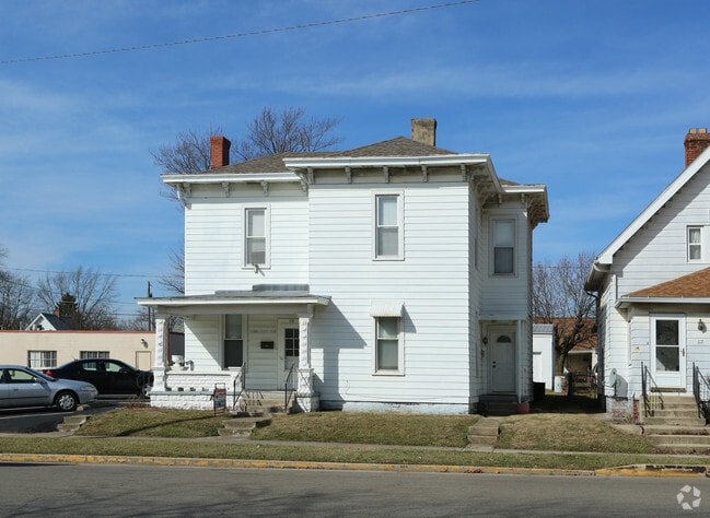
115 E High St, London, OH 43140


Property Detail
115 E High St
31-01838.000
PT LOT 4 WILLIS (164 SF)
Retirementnursinghomecombined
Madison
B and X Area of moderate flood hazard, usually the area between the limits of the 100-year and 500-year floods.
Ohio
2025
0.25 AC
2025
Madison County
040700
Columbus
3,411 SF
Columbus, OH
NEARBY LISTINGS FOR SALE OR LEASE
DEMOGRAPHICS near 115 E High St
1 mile
3 mile
5 mile
2025 Total Population
8,628
13,551
16,148
2030 Population
8,972
14,067
16,759
Pop Growth 2025-2030
+ 3.99%
+ 3.81%
+ 3.78%
Average Age
40
41
41
2025 Total Households
3,157
4,532
5,505
HH Growth 2025-2030
+ 4.31%
+ 4.26%
+ 4.21%
Median Household Inc
$57,197
$62,463
$68,760
Avg Household Size
2.40
2.40
2.40
2025 Avg HH Vehicles
2.00
2.00
2.00
Median Home Value
$196,357
$215,602
$225,906
Median Year Built
1962
1971
1972
Nearby Places
Map Layers
Map Styles
 Street
 Aerial
Layers
 Traffic
 Biking
Places
Listings with unknown addresses are not visible on the map
- Restaurants
- Banks
- Shops
- Fitness
- Groceries
PUBLIC TRANSPORTATION
AIRPORT
Rickenbacker International
Drive
Walk
Distance
Rickenbacker International
50 min
30.4 mi
John Glenn Columbus International
Drive
Walk
Distance
John Glenn Columbus International
44 min
33.6 mi
SALE & LEASE HISTORY
LISTING DATE
SALE/LEASE

Feb 17, 2017
For Sale
Nearby Properties
Address
Land Use
TOTAL SIZE
Lot Size
Zoning
Address
Land Use
TOTAL SIZE
Lot Size
Zoning
21,330 SF
255.27 AC
Address
Land Use
TOTAL SIZE
Lot Size
Zoning
3,144 SF
474.66 AC
Address
Land Use
TOTAL SIZE
Lot Size
Zoning
1,839 AC
Address
Land Use
TOTAL SIZE
Lot Size
Zoning
502,920 SF
53.89 AC
Address
Land Use
TOTAL SIZE
Lot Size
Zoning
11,908 SF
43.73 AC
Address
Land Use
TOTAL SIZE
Lot Size
Zoning
23,286 SF
12.65 AC
Address
Land Use
TOTAL SIZE
Lot Size
Zoning
98,145 SF
22.02 AC
Address
Land Use
TOTAL SIZE
Lot Size
Zoning
84,150 SF
50 AC
Address
Land Use
TOTAL SIZE
Lot Size
Zoning
14,126 SF
45.07 AC
Address
Land Use
TOTAL SIZE
Lot Size
Zoning
8,722 SF
28.93 AC
Address
Land Use
TOTAL SIZE
Lot Size
Zoning
100,200 SF
9.68 AC
Address
Land Use
TOTAL SIZE
Lot Size
Zoning
10,670 SF
30.47 AC
Address
Land Use
TOTAL SIZE
Lot Size
Zoning
7,293 SF
19.32 AC
Address
Land Use
TOTAL SIZE
Lot Size
Zoning
4,000 SF
26.46 AC
Address
Land Use
TOTAL SIZE
Lot Size
Zoning
38,404 SF
16.31 AC
Address
Land Use
TOTAL SIZE
Lot Size
Zoning
204,855 SF
27.78 AC
Address
Land Use
TOTAL SIZE
Lot Size
Zoning
1,668 SF
624.87 AC
Address
Land Use
TOTAL SIZE
Lot Size
Zoning
184,907 SF
21.84 AC
Address
Land Use
TOTAL SIZE
Lot Size
Zoning
34,296 SF
157.24 AC
Address
Land Use
TOTAL SIZE
Lot Size
Zoning
4,998 SF
10.04 AC
Address
Land Use
TOTAL SIZE
Lot Size
Zoning
53,169 SF
6.77 AC
Address
Land Use
TOTAL SIZE
Lot Size
Zoning
2,048 SF
7.59 AC
Address
Land Use
TOTAL SIZE
Lot Size
Zoning
6,344 SF
9.38 AC
Address
Land Use
TOTAL SIZE
Lot Size
Zoning
17,600 SF
10 AC
Address
Land Use
TOTAL SIZE
Lot Size
Zoning
1,928 SF
388.48 AC
Address
Land Use
TOTAL SIZE
Lot Size
Zoning
2,719 SF
10 AC
Address
Land Use
TOTAL SIZE
Lot Size
Zoning
295.79 AC
Address
Land Use
TOTAL SIZE
Lot Size
Zoning
3,492 SF
300.31 AC
Address
Land Use
TOTAL SIZE
Lot Size
Zoning
28,488 SF
3.37 AC
Address
Land Use
TOTAL SIZE
Lot Size
Zoning
5,940 SF
20.94 AC
The World's #1 Commercial Real Estate Marketplace
Connect with us
© 2026 CoStar Group
The information above has been obtained from sources believed reliable. While we do not doubt its accuracy we have not verified it and make no guarantee, warranty or representation about it. It is your responsibility to independently confirm its accuracy and completeness. Any projections, opinions, assumptions, or estimates used are for example only and do not represent the current or future performance of the property. The value of this transaction to you depends on tax and other factors which should be evaluated by your tax, financial, and legal advisors. You and your advisors should conduct a careful, independent investigation of the property to determine to your satisfaction the suitability of the property for your needs.