Property Record
115 Frank St, Struthers, OH 44471
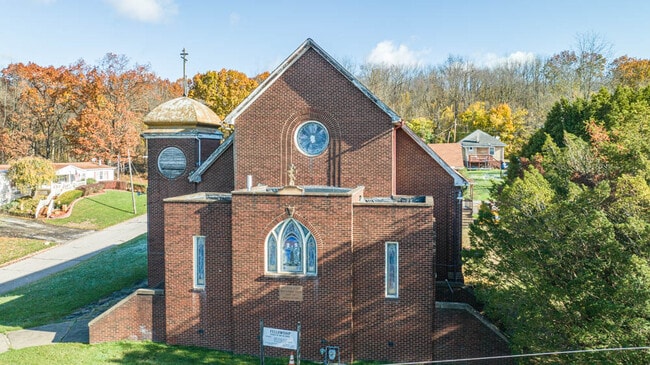

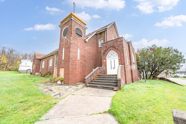
This Property Is For Sale
Property Detail
115 Frank St
Youngstown/Warren/Boardman
LOT 4867 50 X 140 FRANK
Youngstown-Warren, OH
Mahoning
38-002-0-037.01-0
Ohio
Commercialacreage
4867
0
0.16 AC
2025
Mahoning County
810800
NEARBY LISTINGS FOR SALE OR LEASE
-
-
View all Struthers listings for sale on LoopNet.com
DEMOGRAPHICS near 115 Frank St
1 mile
3 mile
5 mile
2025 Total Population
6,047
36,888
90,664
2030 Population
6,131
36,826
90,842
Pop Growth 2025-2030
+ 1.39%
(0.17%)
+ 0.20%
Average Age
39
42
41
2025 Total Households
2,505
15,946
37,697
HH Growth 2025-2030
+ 1.32%
(0.21%)
+ 0.19%
Median Household Inc
$41,867
$47,647
$46,155
Avg Household Size
2.40
2.20
2.20
2025 Avg HH Vehicles
2.00
2.00
2.00
Median Home Value
$78,899
$99,491
$113,525
Median Year Built
1949
1955
1955
Nearby Places
Map Layers
Map Styles
 Street
 Aerial
Layers
 Traffic
 Biking
Places
Listings with unknown addresses are not visible on the map
- Restaurants
- Banks
- Shops
- Fitness
- Groceries
Nearby Properties
Address
Land Use
TOTAL SIZE
Lot Size
Zoning
Address
Land Use
TOTAL SIZE
Lot Size
Zoning
207,180 SF
30.10 AC
Address
Land Use
TOTAL SIZE
Lot Size
Zoning
Address
Land Use
TOTAL SIZE
Lot Size
Zoning
139,416 SF
9.06 AC
Address
Land Use
TOTAL SIZE
Lot Size
Zoning
114,932 SF
22.99 AC
Address
Land Use
TOTAL SIZE
Lot Size
Zoning
0.53 AC
Address
Land Use
TOTAL SIZE
Lot Size
Zoning
115,720 SF
77.12 AC
AG
Address
Land Use
TOTAL SIZE
Lot Size
Zoning
121,281 SF
11.79 AC
Address
Land Use
TOTAL SIZE
Lot Size
Zoning
79,778 SF
5.85 AC
Address
Land Use
TOTAL SIZE
Lot Size
Zoning
53,530 SF
5.85 AC
Address
Land Use
TOTAL SIZE
Lot Size
Zoning
56,688 SF
10.33 AC
R1
Address
Land Use
TOTAL SIZE
Lot Size
Zoning
68,415 SF
11.60 AC
R1
Address
Land Use
TOTAL SIZE
Lot Size
Zoning
74,523 SF
4.04 AC
Address
Land Use
TOTAL SIZE
Lot Size
Zoning
164,368 SF
31.04 AC
Address
Land Use
TOTAL SIZE
Lot Size
Zoning
Address
Land Use
TOTAL SIZE
Lot Size
Zoning
47,337 SF
6.08 AC
Address
Land Use
TOTAL SIZE
Lot Size
Zoning
52,757 SF
5.32 AC
Address
Land Use
TOTAL SIZE
Lot Size
Zoning
65,393 SF
10.73 AC
I
Address
Land Use
TOTAL SIZE
Lot Size
Zoning
19,764 SF
4.06 AC
TC
Address
Land Use
TOTAL SIZE
Lot Size
Zoning
178,520 SF
7.95 AC
I
Address
Land Use
TOTAL SIZE
Lot Size
Zoning
53,712 SF
4.80 AC
TC
Address
Land Use
TOTAL SIZE
Lot Size
Zoning
27,670 SF
10.65 AC
Address
Land Use
TOTAL SIZE
Lot Size
Zoning
29,714 SF
8.18 AC
R2
Address
Land Use
TOTAL SIZE
Lot Size
Zoning
4,800 SF
2.81 AC
TC
Address
Land Use
TOTAL SIZE
Lot Size
Zoning
33,304 SF
11.32 AC
R2
Address
Land Use
TOTAL SIZE
Lot Size
Zoning
70,008 SF
3.31 AC
Address
Land Use
TOTAL SIZE
Lot Size
Zoning
133,948 SF
0.84 AC
Address
Land Use
TOTAL SIZE
Lot Size
Zoning
30,992 SF
15.80 AC
Address
Land Use
TOTAL SIZE
Lot Size
Zoning
31,374 SF
7.70 AC
Address
Land Use
TOTAL SIZE
Lot Size
Zoning
25,839 SF
4.22 AC
Address
Land Use
TOTAL SIZE
Lot Size
Zoning
1,288 SF
2.85 AC
The World's #1 Commercial Real Estate Marketplace
Connect with us
© 2026 CoStar Group
The information above has been obtained from sources believed reliable. While we do not doubt its accuracy we have not verified it and make no guarantee, warranty or representation about it. It is your responsibility to independently confirm its accuracy and completeness. Any projections, opinions, assumptions, or estimates used are for example only and do not represent the current or future performance of the property. The value of this transaction to you depends on tax and other factors which should be evaluated by your tax, financial, and legal advisors. You and your advisors should conduct a careful, independent investigation of the property to determine to your satisfaction the suitability of the property for your needs.