Property Record
115 Jetplex Cir, Madison, AL 35758
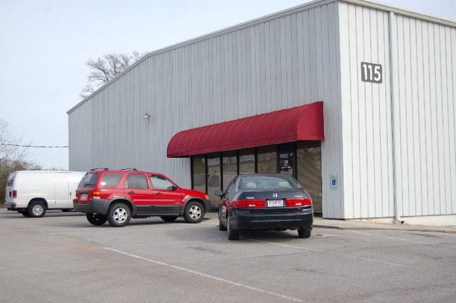

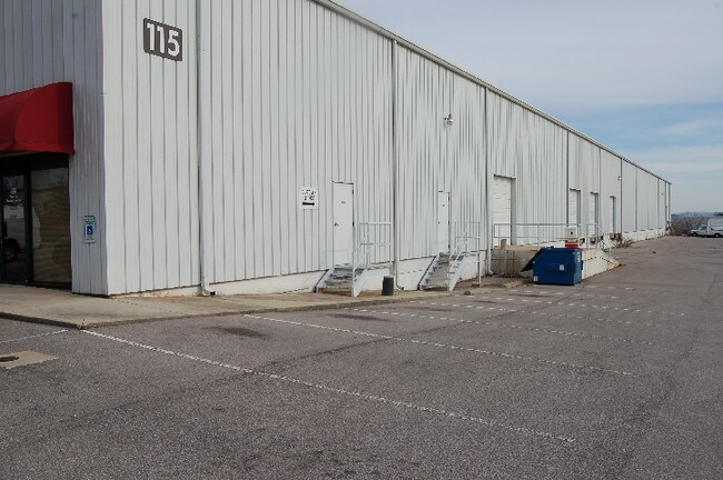

Property Detail
115 Jetplex Cir
Huntsville, AL
LOT 1-B JETPLEX CIRCLE BUSINESS PARK R/S OF LOT 1 JETPLEX CIRCLE BUSINESS PARK R/S OF PRT OF BLK 2 PUTMANS INDUSTRIAL PARK PB
16-09-30-0-000-021.000
Madison
Distributionwarehouseregional
Alabama
B and X Area of moderate flood hazard, usually the area between the limits of the 100-year and 500-year floods.
1-b
2025
2 AC
2025
Jetplex/Madison
011021
Huntsville
29,700 SF
NEARBY LISTINGS FOR SALE OR LEASE
DEMOGRAPHICS near 115 Jetplex Cir
1 mile
3 mile
5 mile
2025 Total Population
358
21,409
68,177
2030 Population
401
23,350
73,757
Pop Growth 2025-2030
+ 12.01%
+ 9.07%
+ 8.18%
Average Age
35
37
38
2025 Total Households
133
8,366
26,768
HH Growth 2025-2030
+ 12.03%
+ 9.04%
+ 8.29%
Median Household Inc
$138,461
$125,575
$115,402
Avg Household Size
2.70
2.50
2.50
2025 Avg HH Vehicles
2.00
2.00
2.00
Median Home Value
$410,869
$444,092
$413,218
Median Year Built
2011
2005
2001
Nearby Places
Map Layers
Map Styles
 Street
 Aerial
Transit
 Traffic
 Biking
Places
Listings with unknown addresses are not visible on the map
- Restaurants
- Banks
- Shops
- Fitness
- Groceries
PUBLIC TRANSPORTATION
AIRPORT
Huntsville International-Carl T Jones Field
Drive
Walk
Distance
Huntsville International-Carl T Jones Field
10 min
3.9 mi
SALE & LEASE HISTORY
LISTING DATE
SALE/LEASE

Sep 25, 2016
For Lease
May 18, 2017
For Lease
Nearby Properties
Address
Land Use
TOTAL SIZE
Lot Size
Zoning
Address
Land Use
TOTAL SIZE
Lot Size
Zoning
91,200 SF
Address
Land Use
TOTAL SIZE
Lot Size
Zoning
584,820 SF
3 AC
Address
Land Use
TOTAL SIZE
Lot Size
Zoning
46,245 SF
21.49 AC
Address
Land Use
TOTAL SIZE
Lot Size
Zoning
1,049,518 SF
100 AC
Address
Land Use
TOTAL SIZE
Lot Size
Zoning
83,201 SF
Address
Land Use
TOTAL SIZE
Lot Size
Zoning
27,558 SF
12.41 AC
Address
Land Use
TOTAL SIZE
Lot Size
Zoning
337,050 SF
66 AC
Address
Land Use
TOTAL SIZE
Lot Size
Zoning
5,487 SF
30 AC
Address
Land Use
TOTAL SIZE
Lot Size
Zoning
30,552 SF
22.24 AC
Address
Land Use
TOTAL SIZE
Lot Size
Zoning
547,730 SF
26 AC
Address
Land Use
TOTAL SIZE
Lot Size
Zoning
29,400 SF
80 AC
Address
Land Use
TOTAL SIZE
Lot Size
Zoning
108,800 SF
Address
Land Use
TOTAL SIZE
Lot Size
Zoning
87.59 AC
Address
Land Use
TOTAL SIZE
Lot Size
Zoning
4,631 SF
41.41 AC
Address
Land Use
TOTAL SIZE
Lot Size
Zoning
13,720 SF
40 AC
Address
Land Use
TOTAL SIZE
Lot Size
Zoning
4,644 SF
20.70 AC
Address
Land Use
TOTAL SIZE
Lot Size
Zoning
194,036 SF
30.29 AC
Address
Land Use
TOTAL SIZE
Lot Size
Zoning
159,547 SF
14.66 AC
Address
Land Use
TOTAL SIZE
Lot Size
Zoning
9,808 SF
10.62 AC
Address
Land Use
TOTAL SIZE
Lot Size
Zoning
7,920 SF
49 AC
Address
Land Use
TOTAL SIZE
Lot Size
Zoning
2,009 SF
20.06 AC
Address
Land Use
TOTAL SIZE
Lot Size
Zoning
553,868 SF
37 AC
Address
Land Use
TOTAL SIZE
Lot Size
Zoning
4,800 SF
49 AC
Address
Land Use
TOTAL SIZE
Lot Size
Zoning
11,255 SF
37 AC
Address
Land Use
TOTAL SIZE
Lot Size
Zoning
1,887 SF
603 AC
Address
Land Use
TOTAL SIZE
Lot Size
Zoning
299,200 SF
33 AC
Address
Land Use
TOTAL SIZE
Lot Size
Zoning
2,687 SF
14 AC
Address
Land Use
TOTAL SIZE
Lot Size
Zoning
38,047 SF
7 AC
Address
Land Use
TOTAL SIZE
Lot Size
Zoning
2,471 SF
14.08 AC
Address
Land Use
TOTAL SIZE
Lot Size
Zoning
207,500 SF
19 AC
The World's #1 Commercial Real Estate Marketplace
Connect with us
© 2026 CoStar Group
The information above has been obtained from sources believed reliable. While we do not doubt its accuracy we have not verified it and make no guarantee, warranty or representation about it. It is your responsibility to independently confirm its accuracy and completeness. Any projections, opinions, assumptions, or estimates used are for example only and do not represent the current or future performance of the property. The value of this transaction to you depends on tax and other factors which should be evaluated by your tax, financial, and legal advisors. You and your advisors should conduct a careful, independent investigation of the property to determine to your satisfaction the suitability of the property for your needs.