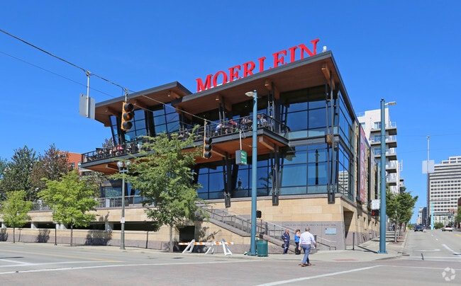
Property Record
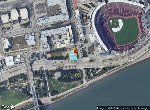
115 Joe Nuxhall Way, Cincinnati, OH 45202

NEARBY LISTINGS FOR SALE OR LEASE
Property Detail
115 Joe Nuxhall Way
Cincinnati, OH-KY-IN
Acbanks Sub Phase Vresub
083-0007-0041
WS MAIN ST LOT 20-E 0.3318 ACBANKS SUB PHASE VRESUB OF LOT 20 PH 4
Restaurantbuilding
Hamilton
AE
Ohio
21037C0007E
20-e
2024
0.33 AC
2024
Cincinnati CBD
026500
Cincinnati/Dayton
DEMOGRAPHICS near 115 Joe Nuxhall Way
1 Mile
3 Mile
5 Mile
2024 Total Population
20,039
149,348
309,942
2029 Population
20,817
152,713
314,593
Pop Growth 2024-2029
+ 3.88%
+ 2.25%
+ 1.50%
Average Age
40
37
37
2024 Total Households
11,727
67,911
135,882
HH Growth 2024-2029
+ 4.14%
+ 2.41%
+ 1.56%
Median Household Inc
$77,549
$50,618
$51,242
Avg Household Size
1.50
2.00
2.10
2024 Avg HH Vehicles
1.00
1.00
1.00
Median Home Value
$383,295
$222,590
$219,312
Median Year Built
1969
1949
1951
Nearby Places
Map Layers
Map Styles
 Street
 Aerial
- Restaurants
- Banks
- Shops
- Fitness
- Groceries
PUBLIC TRANSPORTATION
TRANSIT/SUBWAY
The Banks Station, 2Nd & Main (Streetcar - OTR - Banks - Southwest Ohio Regional Transit Authority)
DRIVE
WALK
Distance
The Banks Station, 2Nd & Main (Streetcar - OTR - Banks - Southwest Ohio Regional Transit Authority)
1 min
3 min
0.2 mi
247 Telemarketing Station, 4Th & Main (Streetcar - OTR - Banks - Southwest Ohio Regional Transit Authority)
DRIVE
WALK
Distance
247 Telemarketing Station, 4Th & Main (Streetcar - OTR - Banks - Southwest Ohio Regional Transit Authority)
1 min
5 min
0.3 mi
Fountain Square Station, 5Th & Walnut (Streetcar - OTR - Banks - Southwest Ohio Regional Transit Authority)
DRIVE
WALK
Distance
Fountain Square Station, 5Th & Walnut (Streetcar - OTR - Banks - Southwest Ohio Regional Transit Authority)
2 min
8 min
0.4 mi
Richter & Phillips Station, 6Th & Main (Streetcar - OTR - Banks - Southwest Ohio Regional Transit Authority)
DRIVE
WALK
Distance
Richter & Phillips Station, 6Th & Main (Streetcar - OTR - Banks - Southwest Ohio Regional Transit Authority)
1 min
9 min
0.5 mi
Aronoff Center Station, 7Th & Walnut (Streetcar - OTR - Banks - Southwest Ohio Regional Transit Authority)
DRIVE
WALK
Distance
Aronoff Center Station, 7Th & Walnut (Streetcar - OTR - Banks - Southwest Ohio Regional Transit Authority)
2 min
15 min
0.7 mi
COMMUTER RAIL
Cincinnati Union Terminal (Cardinal - Amtrak)
DRIVE
WALK
Distance
Cincinnati Union Terminal (Cardinal - Amtrak)
6 min
2.3 mi
AIRPORT
Cincinnati/Northern Kentucky International
DRIVE
WALK
Distance
Cincinnati/Northern Kentucky International
27 min
14.2 mi
Freight Ports
Port of Toledo
DRIVE
WALK
Distance
Port of Toledo
244 min
207.1 mi
Nearby Properties
Address
Land Use
TOTAL SIZE
Lot Size
Zoning
Address
Land Use
TOTAL SIZE
Lot Size
Zoning
77.73 AC
IR
Address
Land Use
TOTAL SIZE
Lot Size
Zoning
39.99 AC
MG
Address
Land Use
TOTAL SIZE
Lot Size
Zoning
11.82 AC
Address
Land Use
TOTAL SIZE
Lot Size
Zoning
19.36 AC
Address
Land Use
TOTAL SIZE
Lot Size
Zoning
17.10 AC
DD
Address
Land Use
TOTAL SIZE
Lot Size
Zoning
1.97 AC
DD
Address
Land Use
TOTAL SIZE
Lot Size
Zoning
11.41 AC
IR
Address
Land Use
TOTAL SIZE
Lot Size
Zoning
13.80 AC
Address
Land Use
TOTAL SIZE
Lot Size
Zoning
411,750 SF
21.25 AC
Address
Land Use
TOTAL SIZE
Lot Size
Zoning
60,750 SF
1.52 AC
Address
Land Use
TOTAL SIZE
Lot Size
Zoning
2.60 AC
Address
Land Use
TOTAL SIZE
Lot Size
Zoning
9.55 AC
Address
Land Use
TOTAL SIZE
Lot Size
Zoning
19.43 AC
Address
Land Use
TOTAL SIZE
Lot Size
Zoning
3.09 AC
Address
Land Use
TOTAL SIZE
Lot Size
Zoning
2.80 AC
IR
Address
Land Use
TOTAL SIZE
Lot Size
Zoning
3.40 AC
IR
Address
Land Use
TOTAL SIZE
Lot Size
Zoning
89,500 SF
0.58 AC
Address
Land Use
TOTAL SIZE
Lot Size
Zoning
290,233 SF
Address
Land Use
TOTAL SIZE
Lot Size
Zoning
3.51 AC
DD
Address
Land Use
TOTAL SIZE
Lot Size
Zoning
9,962 SF
712 AC
Address
Land Use
TOTAL SIZE
Lot Size
Zoning
Address
Land Use
TOTAL SIZE
Lot Size
Zoning
153,312 SF
4 AC
Address
Land Use
TOTAL SIZE
Lot Size
Zoning
9.14 AC
Address
Land Use
TOTAL SIZE
Lot Size
Zoning
11.68 AC
Address
Land Use
TOTAL SIZE
Lot Size
Zoning
21.55 AC
Address
Land Use
TOTAL SIZE
Lot Size
Zoning
298,611 SF
Address
Land Use
TOTAL SIZE
Lot Size
Zoning
20.02 AC
Address
Land Use
TOTAL SIZE
Lot Size
Zoning
12.13 AC
Address
Land Use
TOTAL SIZE
Lot Size
Zoning
165,016 SF
15.23 AC
Address
Land Use
TOTAL SIZE
Lot Size
Zoning
20.49 AC
The World's #1 Commercial Real Estate Marketplace
Connect with us
© 2025 CoStar Group
The information above has been obtained from sources believed reliable. While we do not doubt its accuracy we have not verified it and make no guarantee, warranty or representation about it. It is your responsibility to independently confirm its accuracy and completeness. Any projections, opinions, assumptions, or estimates used are for example only and do not represent the current or future performance of the property. The value of this transaction to you depends on tax and other factors which should be evaluated by your tax, financial, and legal advisors. You and your advisors should conduct a careful, independent investigation of the property to determine to your satisfaction the suitability of the property for your needs.