Property Record
115 Menard Rd, Houma, LA 70363
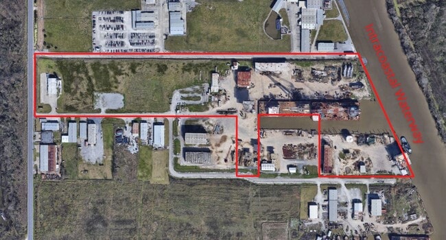
Property Detail
115 Menard Rd
41004
A TRACT CONTAINING 2.300 ACRES ON A MAP ENTITLED SURVEY OF 29.119 ACRES & 3.826 ACRES TRACTS OF LAND BELONGING TO OFFSHORE EX
Medicalbuilding
Terrebonne
AE The base floodplain where base flood elevations are provided. AE Zones are now used on new format FIRMs instead of A1-A30 Zones.
Louisiana
2025
29.12 AC
2024
Other Market Areas
001400
Houma-Bayou Cane-Thibodaux, LA
NEARBY LISTINGS FOR SALE OR LEASE
-
-
View all Houma listings for sale on LoopNet.com
DEMOGRAPHICS near 115 Menard Rd
1 mile
3 mile
5 mile
2025 Total Population
379
28,764
54,496
2030 Population
361
27,347
52,010
Pop Growth 2025-2030
(4.75%)
(4.93%)
(4.56%)
Average Age
42
40
39
2025 Total Households
172
11,255
20,647
HH Growth 2025-2030
(5.23%)
(5.19%)
(4.90%)
Median Household Inc
$55,897
$57,264
$62,547
Avg Household Size
2.20
2.50
2.50
2025 Avg HH Vehicles
2.00
2.00
2.00
Median Home Value
$295,454
$214,694
$207,195
Median Year Built
1973
1975
1978
Nearby Places
Map Layers
Map Styles
 Street
 Aerial
Transit
 Traffic
 Biking
Places
Listings with unknown addresses are not visible on the map
- Restaurants
- Banks
- Shops
- Fitness
- Groceries
SALE & LEASE HISTORY
LISTING DATE
SALE/LEASE

May 13, 2021
For Sale
Jan 06, 2022
For Sale
Nearby Properties
Address
Land Use
TOTAL SIZE
Lot Size
Zoning
Address
Land Use
TOTAL SIZE
Lot Size
Zoning
15.10 AC
Address
Land Use
TOTAL SIZE
Lot Size
Zoning
Address
Land Use
TOTAL SIZE
Lot Size
Zoning
8.60 AC
Address
Land Use
TOTAL SIZE
Lot Size
Zoning
45.77 AC
Address
Land Use
TOTAL SIZE
Lot Size
Zoning
8.21 AC
Address
Land Use
TOTAL SIZE
Lot Size
Zoning
Address
Land Use
TOTAL SIZE
Lot Size
Zoning
140.68 AC
Address
Land Use
TOTAL SIZE
Lot Size
Zoning
Address
Land Use
TOTAL SIZE
Lot Size
Zoning
0.99 AC
Address
Land Use
TOTAL SIZE
Lot Size
Zoning
2.83 AC
Address
Land Use
TOTAL SIZE
Lot Size
Zoning
11.87 AC
Address
Land Use
TOTAL SIZE
Lot Size
Zoning
Address
Land Use
TOTAL SIZE
Lot Size
Zoning
2.92 AC
Address
Land Use
TOTAL SIZE
Lot Size
Zoning
0.62 AC
Address
Land Use
TOTAL SIZE
Lot Size
Zoning
3.35 AC
Address
Land Use
TOTAL SIZE
Lot Size
Zoning
2.78 AC
Address
Land Use
TOTAL SIZE
Lot Size
Zoning
437.01 AC
Address
Land Use
TOTAL SIZE
Lot Size
Zoning
Address
Land Use
TOTAL SIZE
Lot Size
Zoning
3.01 AC
Address
Land Use
TOTAL SIZE
Lot Size
Zoning
23.51 AC
Address
Land Use
TOTAL SIZE
Lot Size
Zoning
Address
Land Use
TOTAL SIZE
Lot Size
Zoning
Address
Land Use
TOTAL SIZE
Lot Size
Zoning
3.65 AC
Address
Land Use
TOTAL SIZE
Lot Size
Zoning
0.87 AC
Address
Land Use
TOTAL SIZE
Lot Size
Zoning
48.71 AC
Address
Land Use
TOTAL SIZE
Lot Size
Zoning
7.25 AC
Address
Land Use
TOTAL SIZE
Lot Size
Zoning
8.93 AC
Address
Land Use
TOTAL SIZE
Lot Size
Zoning
17.06 AC
Address
Land Use
TOTAL SIZE
Lot Size
Zoning
Address
Land Use
TOTAL SIZE
Lot Size
Zoning
70.94 AC
The World's #1 Commercial Real Estate Marketplace
Connect with us
© 2026 CoStar Group
The information above has been obtained from sources believed reliable. While we do not doubt its accuracy we have not verified it and make no guarantee, warranty or representation about it. It is your responsibility to independently confirm its accuracy and completeness. Any projections, opinions, assumptions, or estimates used are for example only and do not represent the current or future performance of the property. The value of this transaction to you depends on tax and other factors which should be evaluated by your tax, financial, and legal advisors. You and your advisors should conduct a careful, independent investigation of the property to determine to your satisfaction the suitability of the property for your needs.