Property Record
115 Merle Ln, Normal, IL 61761
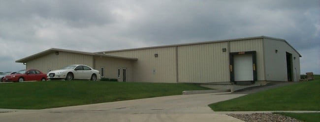

Property Detail
115 Merle Ln
14-30-301-021
JOHNSON SUB 4THA DD LOT 5
Commercialnec
McLean
M-2
Illinois
B and X Area of moderate flood hazard, usually the area between the limits of the 100-year and 500-year floods.
5
2022
2 AC
2024
Other Market Areas
000302
Bloomington, IL
9,040 SF
NEARBY LISTINGS FOR SALE OR LEASE
DEMOGRAPHICS near 115 Merle Ln
1 mile
3 mile
5 mile
2025 Total Population
359
38,027
93,713
2030 Population
355
38,271
94,214
Pop Growth 2025-2030
(1.11%)
+ 0.64%
+ 0.53%
Average Age
35
32
37
2025 Total Households
152
13,447
38,466
HH Growth 2025-2030
(1.32%)
+ 0.64%
+ 0.56%
Median Household Inc
$32,812
$48,060
$60,750
Avg Household Size
2.30
2.20
2.10
2025 Avg HH Vehicles
1.00
2.00
2.00
Median Home Value
$210,000
$167,975
$182,944
Median Year Built
1992
1977
1976
Nearby Places
Map Layers
Map Styles
 Street
 Aerial
Transit
 Traffic
 Biking
Places
Listings with unknown addresses are not visible on the map
- Restaurants
- Banks
- Shops
- Fitness
- Groceries
PUBLIC TRANSPORTATION
COMMUTER RAIL
Drive
Walk
Distance
7 min
3.2 mi
AIRPORT
Central Il Regional/Bloomington-Normal
Drive
Walk
Distance
Central Il Regional/Bloomington-Normal
21 min
8.4 mi
General Downing - Peoria International
Drive
Walk
Distance
General Downing - Peoria International
51 min
41.7 mi
Nearby Properties
Address
Land Use
TOTAL SIZE
Lot Size
Zoning
Address
Land Use
TOTAL SIZE
Lot Size
Zoning
417.42 AC
Address
Land Use
TOTAL SIZE
Lot Size
Zoning
154,502 SF
1.25 AC
Address
Land Use
TOTAL SIZE
Lot Size
Zoning
493,944 SF
2.95 AC
R-3A
Address
Land Use
TOTAL SIZE
Lot Size
Zoning
48,629 SF
39 AC
Address
Land Use
TOTAL SIZE
Lot Size
Zoning
127,569 SF
1.54 AC
Address
Land Use
TOTAL SIZE
Lot Size
Zoning
158,508 SF
3.13 AC
R1C
Address
Land Use
TOTAL SIZE
Lot Size
Zoning
126,418 SF
1.06 AC
Address
Land Use
TOTAL SIZE
Lot Size
Zoning
432,093 SF
15 AC
Address
Land Use
TOTAL SIZE
Lot Size
Zoning
10.13 AC
R2
Address
Land Use
TOTAL SIZE
Lot Size
Zoning
422,234 SF
23.17 AC
Address
Land Use
TOTAL SIZE
Lot Size
Zoning
309,750 SF
9.85 AC
R-3A
Address
Land Use
TOTAL SIZE
Lot Size
Zoning
351,360 SF
8.40 AC
R-3A
Address
Land Use
TOTAL SIZE
Lot Size
Zoning
191,880 SF
3 AC
B-1
Address
Land Use
TOTAL SIZE
Lot Size
Zoning
86,950 SF
4 AC
B-1
Address
Land Use
TOTAL SIZE
Lot Size
Zoning
98,646 SF
4 AC
B-1
Address
Land Use
TOTAL SIZE
Lot Size
Zoning
127,720 SF
1.68 AC
R-1C
Address
Land Use
TOTAL SIZE
Lot Size
Zoning
62,551 SF
0.42 AC
B-2
Address
Land Use
TOTAL SIZE
Lot Size
Zoning
84,278 SF
0.36 AC
B-2
Address
Land Use
TOTAL SIZE
Lot Size
Zoning
51,320 SF
0.70 AC
B-1
Address
Land Use
TOTAL SIZE
Lot Size
Zoning
118,176 SF
2.30 AC
Address
Land Use
TOTAL SIZE
Lot Size
Zoning
34,720 SF
6.14 AC
R3A
Address
Land Use
TOTAL SIZE
Lot Size
Zoning
51,320 SF
0.50 AC
B-1
Address
Land Use
TOTAL SIZE
Lot Size
Zoning
126,428 SF
3.79 AC
Address
Land Use
TOTAL SIZE
Lot Size
Zoning
105,448 SF
5.84 AC
B-1
Address
Land Use
TOTAL SIZE
Lot Size
Zoning
348,318 SF
7 AC
R-3A
Address
Land Use
TOTAL SIZE
Lot Size
Zoning
196,500 SF
5.07 AC
Address
Land Use
TOTAL SIZE
Lot Size
Zoning
36,784 SF
0.62 AC
B-1
The World's #1 Commercial Real Estate Marketplace
Connect with us
© 2026 CoStar Group
The information above has been obtained from sources believed reliable. While we do not doubt its accuracy we have not verified it and make no guarantee, warranty or representation about it. It is your responsibility to independently confirm its accuracy and completeness. Any projections, opinions, assumptions, or estimates used are for example only and do not represent the current or future performance of the property. The value of this transaction to you depends on tax and other factors which should be evaluated by your tax, financial, and legal advisors. You and your advisors should conduct a careful, independent investigation of the property to determine to your satisfaction the suitability of the property for your needs.