Property Record
115 N 20Th Ave, Cornelius, OR 97113
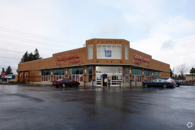
Property Detail
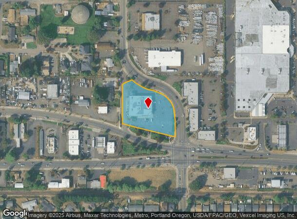
115 N 20Th Ave
Portland-Vancouver-Hillsboro, OR-WA
2005-062 Partition Plat
R2140647
2005-062 PARTITION PLAT, LOT 1, ACRES 1.67
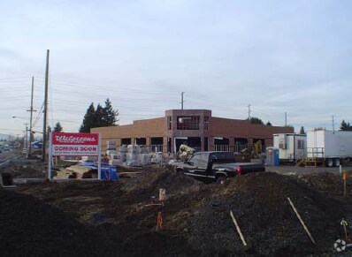
Commercialbuilding
Washington
X
Oregon
41067C0318E
1
2024
1.67 AC
2026
Westside Outlying
032901
Portland
14,820 SF
NEARBY LISTINGS FOR SALE OR LEASE
DEMOGRAPHICS near 115 N 20Th Ave
1 mile
3 mile
5 mile
2024 Total Population
11,700
34,830
89,234
2029 Population
11,849
35,231
89,725
Pop Growth 2024-2029
+ 1.27%
+ 1.15%
+ 0.55%
Average Age
37
38
38
2024 Total Households
3,450
11,504
29,718
HH Growth 2024-2029
+ 1.36%
+ 1.22%
+ 0.60%
Median Household Inc
$68,482
$67,747
$78,469
Avg Household Size
3.30
2.90
2.90
2024 Avg HH Vehicles
2.00
2.00
2.00
Median Home Value
$363,401
$397,190
$431,908
Median Year Built
1984
1981
1982
Nearby Places
Map Layers
Map Styles
 Street
 Aerial
Transit
 Traffic
 Biking
Places
Listings with unknown addresses are not visible on the map
- Restaurants
- Banks
- Shops
- Fitness
- Groceries
PUBLIC TRANSPORTATION
AIRPORT
Portland International
Drive
Walk
Distance
Portland International
54 min
36.4 mi
Freight Ports
Port of Portland
Drive
Walk
Distance
Port of Portland
38 min
25.4 mi
SALE & LEASE HISTORY
LISTING DATE
SALE/LEASE

Dec 06, 2016
For Sale
Nearby Properties
Address
Land Use
TOTAL SIZE
Lot Size
Zoning
Address
Land Use
TOTAL SIZE
Lot Size
Zoning
9.97 AC
SCC-DT
Address
Land Use
TOTAL SIZE
Lot Size
Zoning
608,403 SF
30.03 AC
RMH
Address
Land Use
TOTAL SIZE
Lot Size
Zoning
79,574 SF
16.54 AC
GI
Address
Land Use
TOTAL SIZE
Lot Size
Zoning
252,251 SF
2.62 AC
SCC-DT
Address
Land Use
TOTAL SIZE
Lot Size
Zoning
13.80 AC
GI
Address
Land Use
TOTAL SIZE
Lot Size
Zoning
108.84 AC
GI
Address
Land Use
TOTAL SIZE
Lot Size
Zoning
154,371 SF
15.63 AC
C2
Address
Land Use
TOTAL SIZE
Lot Size
Zoning
1.22 AC
I-G
Address
Land Use
TOTAL SIZE
Lot Size
Zoning
20.62 AC
I-G
Address
Land Use
TOTAL SIZE
Lot Size
Zoning
2.83 AC
GMU
Address
Land Use
TOTAL SIZE
Lot Size
Zoning
169,980 SF
14 AC
GMU
Address
Land Use
TOTAL SIZE
Lot Size
Zoning
37,000 SF
29.09 AC
INST
Address
Land Use
TOTAL SIZE
Lot Size
Zoning
65,500 SF
9.67 AC
R7
Address
Land Use
TOTAL SIZE
Lot Size
Zoning
86,022 SF
0.09 AC
SCC-DT
Address
Land Use
TOTAL SIZE
Lot Size
Zoning
0.05 AC
LI
Address
Land Use
TOTAL SIZE
Lot Size
Zoning
20.48 AC
LI
Address
Land Use
TOTAL SIZE
Lot Size
Zoning
222,852 SF
11.17 AC
RMH
Address
Land Use
TOTAL SIZE
Lot Size
Zoning
102,902 SF
6.19 AC
I-G
Address
Land Use
TOTAL SIZE
Lot Size
Zoning
72,365 SF
11.25 AC
R7
Address
Land Use
TOTAL SIZE
Lot Size
Zoning
46,000 SF
7.68 AC
INST
Address
Land Use
TOTAL SIZE
Lot Size
Zoning
137,200 SF
9.52 AC
INST
Address
Land Use
TOTAL SIZE
Lot Size
Zoning
176,108 SF
0.44 AC
CC
Address
Land Use
TOTAL SIZE
Lot Size
Zoning
98,100 SF
1.70 AC
SCC-DT
Address
Land Use
TOTAL SIZE
Lot Size
Zoning
9.53 AC
SFR-7
Address
Land Use
TOTAL SIZE
Lot Size
Zoning
32,187 SF
9.19 AC
AF-5
Address
Land Use
TOTAL SIZE
Lot Size
Zoning
7.35 AC
Address
Land Use
TOTAL SIZE
Lot Size
Zoning
199,045 SF
0.16 AC
SCC-DT
Address
Land Use
TOTAL SIZE
Lot Size
Zoning
1,224 SF
32.69 AC
R-7
Address
Land Use
TOTAL SIZE
Lot Size
Zoning
Address
Land Use
TOTAL SIZE
Lot Size
Zoning
1,210 SF
4.50 AC
CC
The World's #1 Commercial Real Estate Marketplace
Connect with us
© 2026 CoStar Group
The information above has been obtained from sources believed reliable. While we do not doubt its accuracy we have not verified it and make no guarantee, warranty or representation about it. It is your responsibility to independently confirm its accuracy and completeness. Any projections, opinions, assumptions, or estimates used are for example only and do not represent the current or future performance of the property. The value of this transaction to you depends on tax and other factors which should be evaluated by your tax, financial, and legal advisors. You and your advisors should conduct a careful, independent investigation of the property to determine to your satisfaction the suitability of the property for your needs.