Property Record
115 N General Bruce Dr, Temple, TX 76504
NEARBY LISTINGS FOR SALE OR LEASE
Property Detail
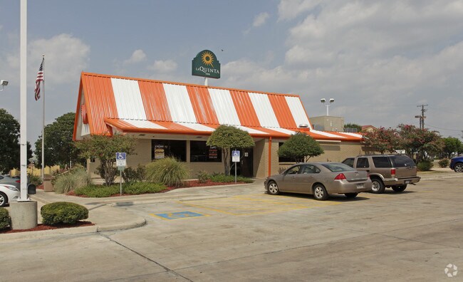
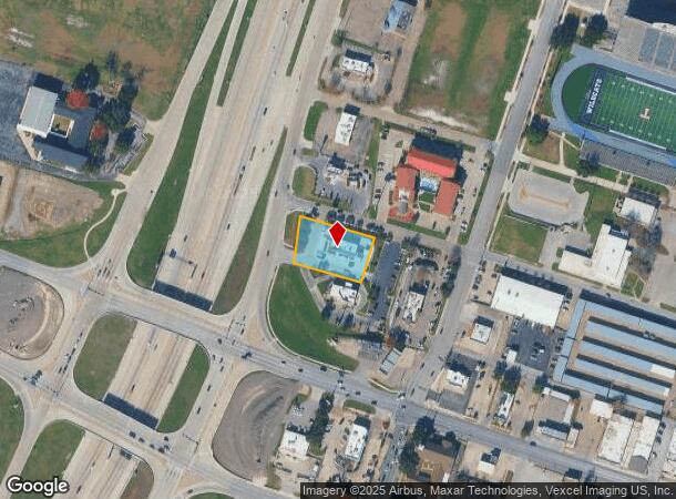
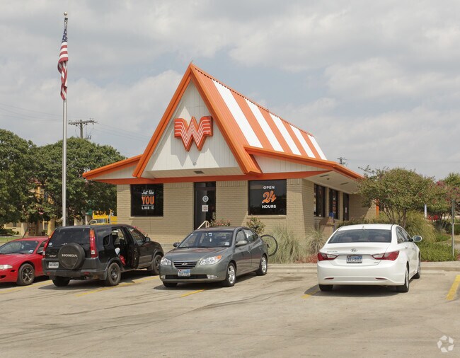
115 N General Bruce Dr
Killeen-Temple, TX
Whataburger
126949
WHATABURGER, BLOCK 001, LOT 0001, ACRES .73
Commercialnec
Bell
X
Texas
48027C0355E
1
2024
0.73 AC
2025
Temple
020702
Killeen/Temple/Fort Hood
2,920 SF
DEMOGRAPHICS near 115 N General Bruce Dr
1 Mile
3 Mile
5 Mile
2024 Total Population
8,194
51,117
87,371
2029 Population
9,287
57,541
98,821
Pop Growth 2024-2029
+ 13.34%
+ 12.57%
+ 13.11%
Average Age
38
39
38
2024 Total Households
3,415
21,764
35,155
HH Growth 2024-2029
+ 13.44%
+ 12.83%
+ 13.33%
Median Household Inc
$35,923
$43,175
$55,639
Avg Household Size
2.30
2.20
2.40
2024 Avg HH Vehicles
1.00
2.00
2.00
Median Home Value
$148,979
$152,630
$189,501
Median Year Built
1976
1979
1989
Nearby Places
Map Layers
Map Styles
 Street
 Aerial
- Restaurants
- Banks
- Shops
- Fitness
- Groceries
PUBLIC TRANSPORTATION
COMMUTER RAIL
Temple (Texas Eagle - Amtrak)
DRIVE
WALK
Distance
Temple (Texas Eagle - Amtrak)
2 min
1.1 mi
AIRPORT
Killeen Municipal
DRIVE
WALK
Distance
Killeen Municipal
27 min
22.5 mi
Robert Gray AAF
DRIVE
WALK
Distance
Robert Gray AAF
47 min
36.4 mi
Freight Ports
Port of Houston
DRIVE
WALK
Distance
Port of Houston
230 min
175.7 mi
Nearby Properties
Address
Land Use
TOTAL SIZE
Lot Size
Zoning
Address
Land Use
TOTAL SIZE
Lot Size
Zoning
1,656,661 SF
194.39 AC
Address
Land Use
TOTAL SIZE
Lot Size
Zoning
1,546,481 SF
111.97 AC
MF2
Address
Land Use
TOTAL SIZE
Lot Size
Zoning
274,710 SF
38.05 AC
C
Address
Land Use
TOTAL SIZE
Lot Size
Zoning
612,900 SF
38.68 AC
Address
Land Use
TOTAL SIZE
Lot Size
Zoning
208,941 SF
9.23 AC
Address
Land Use
TOTAL SIZE
Lot Size
Zoning
1 SF
30.52 AC
Address
Land Use
TOTAL SIZE
Lot Size
Zoning
250,571 SF
12 AC
Address
Land Use
TOTAL SIZE
Lot Size
Zoning
200,642 SF
9.01 AC
Address
Land Use
TOTAL SIZE
Lot Size
Zoning
202,292 SF
10.17 AC
Address
Land Use
TOTAL SIZE
Lot Size
Zoning
86,326 SF
8.70 AC
MF1
Address
Land Use
TOTAL SIZE
Lot Size
Zoning
77,450 SF
16.51 AC
Address
Land Use
TOTAL SIZE
Lot Size
Zoning
216,109 SF
8.16 AC
Address
Land Use
TOTAL SIZE
Lot Size
Zoning
198,957 SF
15.18 AC
Address
Land Use
TOTAL SIZE
Lot Size
Zoning
180,360 SF
9.66 AC
Address
Land Use
TOTAL SIZE
Lot Size
Zoning
1 SF
15 AC
SCHL
Address
Land Use
TOTAL SIZE
Lot Size
Zoning
Address
Land Use
TOTAL SIZE
Lot Size
Zoning
167,344 SF
11.29 AC
Address
Land Use
TOTAL SIZE
Lot Size
Zoning
195,291 SF
36.30 AC
Address
Land Use
TOTAL SIZE
Lot Size
Zoning
Address
Land Use
TOTAL SIZE
Lot Size
Zoning
287,006 SF
22.67 AC
Address
Land Use
TOTAL SIZE
Lot Size
Zoning
71,378 SF
13.75 AC
A
Address
Land Use
TOTAL SIZE
Lot Size
Zoning
214,028 SF
14.37 AC
Address
Land Use
TOTAL SIZE
Lot Size
Zoning
Address
Land Use
TOTAL SIZE
Lot Size
Zoning
228,154 SF
17.95 AC
Address
Land Use
TOTAL SIZE
Lot Size
Zoning
168,754 SF
10.36 AC
LI
Address
Land Use
TOTAL SIZE
Lot Size
Zoning
Address
Land Use
TOTAL SIZE
Lot Size
Zoning
71,382 SF
59.32 AC
Address
Land Use
TOTAL SIZE
Lot Size
Zoning
175,904 SF
20.33 AC
C
Address
Land Use
TOTAL SIZE
Lot Size
Zoning
45,641 SF
3.94 AC
O
Address
Land Use
TOTAL SIZE
Lot Size
Zoning
188,072 SF
9.51 AC
C
The World's #1 Commercial Real Estate Marketplace
Connect with us
© 2026 CoStar Group
The information above has been obtained from sources believed reliable. While we do not doubt its accuracy we have not verified it and make no guarantee, warranty or representation about it. It is your responsibility to independently confirm its accuracy and completeness. Any projections, opinions, assumptions, or estimates used are for example only and do not represent the current or future performance of the property. The value of this transaction to you depends on tax and other factors which should be evaluated by your tax, financial, and legal advisors. You and your advisors should conduct a careful, independent investigation of the property to determine to your satisfaction the suitability of the property for your needs.