Property Record
115 N High St, Randolph, WI 53956
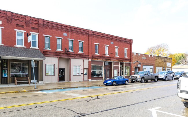
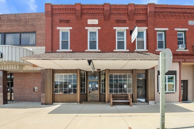
This Property Is For Sale
Property Detail
115 N High St
Madison, WI
LOT 1, CSM 2665-17-118; EXC CS 2760 -18-83
11176-136
Columbia
Commercialnec
Wisconsin
B and X Area of moderate flood hazard, usually the area between the limits of the 100-year and 500-year floods.
1
2025
0.14 AC
2025
Columbia County
970100
Milwaukee/Madison
NEARBY LISTINGS FOR SALE OR LEASE
DEMOGRAPHICS near 115 N High St
1 mile
3 mile
5 mile
2025 Total Population
1,923
2,421
6,128
2030 Population
1,905
2,399
6,179
Pop Growth 2025-2030
(0.94%)
(0.91%)
+ 0.83%
Average Age
41
42
43
2025 Total Households
745
913
2,226
HH Growth 2025-2030
(0.94%)
(0.88%)
+ 1.17%
Median Household Inc
$66,573
$69,908
$77,598
Avg Household Size
2.40
2.40
2.40
2025 Avg HH Vehicles
2.00
2.00
2.00
Median Home Value
$195,069
$212,946
$250,279
Median Year Built
1965
1965
1965
Nearby Places
Map Layers
Map Styles
 Street
 Aerial
Layers
 Traffic
 Biking
Places
Listings with unknown addresses are not visible on the map
- Restaurants
- Banks
- Shops
- Fitness
- Groceries
PUBLIC TRANSPORTATION
AIRPORT
Dane County Regional/Truax Field
Drive
Walk
Distance
Dane County Regional/Truax Field
58 min
40.6 mi
Nearby Properties
Address
Land Use
TOTAL SIZE
Lot Size
Zoning
Address
Land Use
TOTAL SIZE
Lot Size
Zoning
19.91 AC
Address
Land Use
TOTAL SIZE
Lot Size
Zoning
5.36 AC
Address
Land Use
TOTAL SIZE
Lot Size
Zoning
17.10 AC
Address
Land Use
TOTAL SIZE
Lot Size
Zoning
9.85 AC
Address
Land Use
TOTAL SIZE
Lot Size
Zoning
7.39 AC
Address
Land Use
TOTAL SIZE
Lot Size
Zoning
2.39 AC
Address
Land Use
TOTAL SIZE
Lot Size
Zoning
1.50 AC
Address
Land Use
TOTAL SIZE
Lot Size
Zoning
1.44 AC
Address
Land Use
TOTAL SIZE
Lot Size
Zoning
16.17 AC
Address
Land Use
TOTAL SIZE
Lot Size
Zoning
1.51 AC
Address
Land Use
TOTAL SIZE
Lot Size
Zoning
1.93 AC
Address
Land Use
TOTAL SIZE
Lot Size
Zoning
35.53 AC
Address
Land Use
TOTAL SIZE
Lot Size
Zoning
2.86 AC
Address
Land Use
TOTAL SIZE
Lot Size
Zoning
12.74 AC
Address
Land Use
TOTAL SIZE
Lot Size
Zoning
1.92 AC
Address
Land Use
TOTAL SIZE
Lot Size
Zoning
1.27 AC
Address
Land Use
TOTAL SIZE
Lot Size
Zoning
0.60 AC
Address
Land Use
TOTAL SIZE
Lot Size
Zoning
1.07 AC
Address
Land Use
TOTAL SIZE
Lot Size
Zoning
29.13 AC
Address
Land Use
TOTAL SIZE
Lot Size
Zoning
0.48 AC
Address
Land Use
TOTAL SIZE
Lot Size
Zoning
0.35 AC
Address
Land Use
TOTAL SIZE
Lot Size
Zoning
1.53 AC
Address
Land Use
TOTAL SIZE
Lot Size
Zoning
0.14 AC
Address
Land Use
TOTAL SIZE
Lot Size
Zoning
Address
Land Use
TOTAL SIZE
Lot Size
Zoning
Address
Land Use
TOTAL SIZE
Lot Size
Zoning
Address
Land Use
TOTAL SIZE
Lot Size
Zoning
73.60 AC
Address
Land Use
TOTAL SIZE
Lot Size
Zoning
Address
Land Use
TOTAL SIZE
Lot Size
Zoning
Address
Land Use
TOTAL SIZE
Lot Size
Zoning
The World's #1 Commercial Real Estate Marketplace
Connect with us
© 2026 CoStar Group
The information above has been obtained from sources believed reliable. While we do not doubt its accuracy we have not verified it and make no guarantee, warranty or representation about it. It is your responsibility to independently confirm its accuracy and completeness. Any projections, opinions, assumptions, or estimates used are for example only and do not represent the current or future performance of the property. The value of this transaction to you depends on tax and other factors which should be evaluated by your tax, financial, and legal advisors. You and your advisors should conduct a careful, independent investigation of the property to determine to your satisfaction the suitability of the property for your needs.