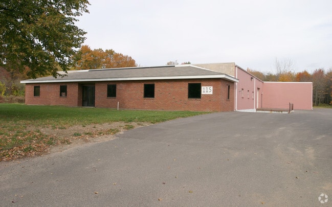
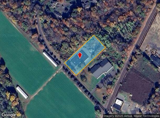
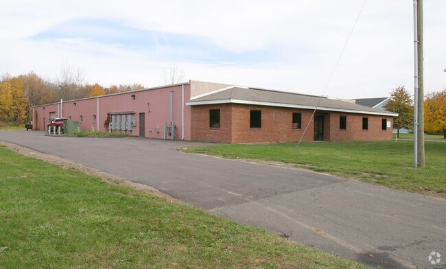
Property Record
115 Pierson Ln, Windsor, CT 06095
NEARBY LISTINGS FOR SALE OR LEASE
Property Detail
115 Pierson Ln
WIND-000075-000112-000016A
Hartford
Multipleuses
Connecticut
X
16a
09003C0357F
1.97 AC
2024
Windsor
2025
Hartford
473601
Hartford-West Hartford-East Hartford, CT
DEMOGRAPHICS near 115 Pierson Ln
1 Mile
3 Mile
5 Mile
2024 Total Population
3,942
22,412
71,175
2029 Population
3,885
22,248
70,813
Pop Growth 2024-2029
(1.45%)
(0.73%)
(0.51%)
Average Age
43
43
43
2024 Total Households
1,729
8,890
28,416
HH Growth 2024-2029
(1.79%)
(0.92%)
(0.63%)
Median Household Inc
$84,538
$96,451
$87,790
Avg Household Size
2.20
2.40
2.40
2024 Avg HH Vehicles
2.00
2.00
2.00
Median Home Value
$246,105
$248,235
$243,467
Median Year Built
1966
1965
1967
Nearby Places
Map Layers
Map Styles
 Street
 Aerial
- Restaurants
- Banks
- Shops
- Fitness
- Groceries
PUBLIC TRANSPORTATION
COMMUTER RAIL
DRIVE
WALK
Distance
3 min
20 min
1.0 mi
Windsor Locks (Hartford Line - CT Rail (CTRail))
DRIVE
WALK
Distance
Windsor Locks (Hartford Line - CT Rail (CTRail))
8 min
4.5 mi
AIRPORT
Bradley International
DRIVE
WALK
Distance
Bradley International
19 min
6.7 mi
Freight Ports
Port of New Haven
DRIVE
WALK
Distance
Port of New Haven
65 min
47.4 mi
Nearby Properties
Address
Land Use
TOTAL SIZE
Lot Size
Zoning
Address
Land Use
TOTAL SIZE
Lot Size
Zoning
13,680 SF
240.83 AC
Address
Land Use
TOTAL SIZE
Lot Size
Zoning
492,240 SF
40.80 AC
Address
Land Use
TOTAL SIZE
Lot Size
Zoning
164,765 SF
17.40 AC
Address
Land Use
TOTAL SIZE
Lot Size
Zoning
659,693 SF
102.30 AC
I
Address
Land Use
TOTAL SIZE
Lot Size
Zoning
6.50 AC
Address
Land Use
TOTAL SIZE
Lot Size
Zoning
35.05 AC
FP
Address
Land Use
TOTAL SIZE
Lot Size
Zoning
203,071 SF
17.46 AC
Address
Land Use
TOTAL SIZE
Lot Size
Zoning
177,630 SF
32.64 AC
Address
Land Use
TOTAL SIZE
Lot Size
Zoning
247,428 SF
35.46 AC
Address
Land Use
TOTAL SIZE
Lot Size
Zoning
302,370 SF
16.43 AC
I
Address
Land Use
TOTAL SIZE
Lot Size
Zoning
488,812 SF
77.31 AC
Address
Land Use
TOTAL SIZE
Lot Size
Zoning
183,263 SF
21.69 AC
Address
Land Use
TOTAL SIZE
Lot Size
Zoning
416,640 SF
30 AC
I
Address
Land Use
TOTAL SIZE
Lot Size
Zoning
11.65 AC
Address
Land Use
TOTAL SIZE
Lot Size
Zoning
25.92 AC
Address
Land Use
TOTAL SIZE
Lot Size
Zoning
44,054 SF
16.87 AC
A-1
Address
Land Use
TOTAL SIZE
Lot Size
Zoning
768 SF
15.72 AC
Address
Land Use
TOTAL SIZE
Lot Size
Zoning
34,045 SF
181.32 AC
B-2
Address
Land Use
TOTAL SIZE
Lot Size
Zoning
65,592 SF
6.66 AC
Address
Land Use
TOTAL SIZE
Lot Size
Zoning
170,076 SF
24.02 AC
Address
Land Use
TOTAL SIZE
Lot Size
Zoning
82,784 SF
7.07 AC
Address
Land Use
TOTAL SIZE
Lot Size
Zoning
52.53 AC
Address
Land Use
TOTAL SIZE
Lot Size
Zoning
166,420 SF
15.83 AC
Address
Land Use
TOTAL SIZE
Lot Size
Zoning
198,750 SF
14.98 AC
Address
Land Use
TOTAL SIZE
Lot Size
Zoning
87,963 SF
9.53 AC
Address
Land Use
TOTAL SIZE
Lot Size
Zoning
11,212 SF
15.54 AC
Address
Land Use
TOTAL SIZE
Lot Size
Zoning
325,600 SF
51.25 AC
Address
Land Use
TOTAL SIZE
Lot Size
Zoning
168,000 SF
13.86 AC
I
Address
Land Use
TOTAL SIZE
Lot Size
Zoning
50,160 SF
4.31 AC
Address
Land Use
TOTAL SIZE
Lot Size
Zoning
76,125 SF
30.11 AC
The World's #1 Commercial Real Estate Marketplace
Connect with us
© 2026 CoStar Group
The information above has been obtained from sources believed reliable. While we do not doubt its accuracy we have not verified it and make no guarantee, warranty or representation about it. It is your responsibility to independently confirm its accuracy and completeness. Any projections, opinions, assumptions, or estimates used are for example only and do not represent the current or future performance of the property. The value of this transaction to you depends on tax and other factors which should be evaluated by your tax, financial, and legal advisors. You and your advisors should conduct a careful, independent investigation of the property to determine to your satisfaction the suitability of the property for your needs.