Property Record
115 River St, Elk Rapids, MI 49629


Save to a Folder
{{folder.Name}}
{{folder.ListingIds.length}} Properties
{{folder.ListingIds.length}} Property
Create a New Folder
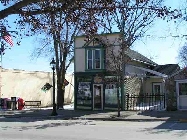
Property Detail
115 River St
Other Market Areas
PARCEL B..PART OF LOT 2; PLAT OF THE VILLAGE OF ELK RAPIDS; DESC AS; COM AT THE NE COR OF LOT 2; TH S 75 DEG E 47.69 FT FOR
05-43-010-003-10
ANTRIM
Storebuilding
Michigan
2025
2
2026
0.17 AC
960600
Michigan North Central Area
525 SF
NEARBY LISTINGS FOR SALE OR LEASE
-
-
View all Elk Rapids listings for sale on LoopNet.com
DEMOGRAPHICS near 115 River St
1 mile
3 mile
5 mile
2025 Total Population
1,860
3,286
6,339
2030 Population
1,962
3,493
6,717
Pop Growth 2025-2030
+ 5.48%
+ 6.30%
+ 5.96%
Average Age
51
51
50
2025 Total Households
883
1,558
2,888
HH Growth 2025-2030
+ 5.66%
+ 6.35%
+ 6.06%
Median Household Inc
$79,722
$80,918
$87,967
Avg Household Size
2.10
2.10
2.20
2025 Avg HH Vehicles
2.00
2.00
2.00
Median Home Value
$379,761
$387,368
$473,538
Median Year Built
1974
1977
1981
Nearby Places
Map Layers
Map Styles
 Street
 Aerial
Layers
 Traffic
 Biking
Places
Listings with unknown addresses are not visible on the map
- Restaurants
- Banks
- Shops
- Fitness
- Groceries
PUBLIC TRANSPORTATION
AIRPORT
Cherry Capital
Drive
Walk
Distance
Cherry Capital
29 min
16.4 mi
Nearby Properties
Address
Land Use
TOTAL SIZE
Lot Size
Zoning
Address
Land Use
TOTAL SIZE
Lot Size
Zoning
9.81 AC
Address
Land Use
TOTAL SIZE
Lot Size
Zoning
Address
Land Use
TOTAL SIZE
Lot Size
Zoning
2,695 SF
67.50 AC
Address
Land Use
TOTAL SIZE
Lot Size
Zoning
0.30 AC
Address
Land Use
TOTAL SIZE
Lot Size
Zoning
2.97 AC
Address
Land Use
TOTAL SIZE
Lot Size
Zoning
17,188 SF
1.05 AC
Address
Land Use
TOTAL SIZE
Lot Size
Zoning
7,951 SF
54.72 AC
Address
Land Use
TOTAL SIZE
Lot Size
Zoning
2.88 AC
Address
Land Use
TOTAL SIZE
Lot Size
Zoning
3.44 AC
Address
Land Use
TOTAL SIZE
Lot Size
Zoning
11.54 AC
Address
Land Use
TOTAL SIZE
Lot Size
Zoning
1.17 AC
Address
Land Use
TOTAL SIZE
Lot Size
Zoning
17,885 SF
1.72 AC
Address
Land Use
TOTAL SIZE
Lot Size
Zoning
1.14 AC
Address
Land Use
TOTAL SIZE
Lot Size
Zoning
0.90 AC
Address
Land Use
TOTAL SIZE
Lot Size
Zoning
79.80 AC
Address
Land Use
TOTAL SIZE
Lot Size
Zoning
6,084 SF
0.07 AC
Address
Land Use
TOTAL SIZE
Lot Size
Zoning
1,788 SF
121.59 AC
Address
Land Use
TOTAL SIZE
Lot Size
Zoning
12.78 AC
Address
Land Use
TOTAL SIZE
Lot Size
Zoning
45,294 SF
1.96 AC
Address
Land Use
TOTAL SIZE
Lot Size
Zoning
28,360 SF
3.50 AC
Address
Land Use
TOTAL SIZE
Lot Size
Zoning
0.18 AC
Address
Land Use
TOTAL SIZE
Lot Size
Zoning
10,764 SF
3.79 AC
Address
Land Use
TOTAL SIZE
Lot Size
Zoning
0.65 AC
Address
Land Use
TOTAL SIZE
Lot Size
Zoning
1.32 AC
Address
Land Use
TOTAL SIZE
Lot Size
Zoning
0.20 AC
Address
Land Use
TOTAL SIZE
Lot Size
Zoning
0.90 AC
Address
Land Use
TOTAL SIZE
Lot Size
Zoning
4,208 SF
0.68 AC
Address
Land Use
TOTAL SIZE
Lot Size
Zoning
0.16 AC
Address
Land Use
TOTAL SIZE
Lot Size
Zoning
0.98 AC
Address
Land Use
TOTAL SIZE
Lot Size
Zoning
0.29 AC
The World's #1 Commercial Real Estate Marketplace
Connect with us
© 2026 CoStar Group
The information above has been obtained from sources believed reliable. While we do not doubt its accuracy we have not verified it and make no guarantee, warranty or representation about it. It is your responsibility to independently confirm its accuracy and completeness. Any projections, opinions, assumptions, or estimates used are for example only and do not represent the current or future performance of the property. The value of this transaction to you depends on tax and other factors which should be evaluated by your tax, financial, and legal advisors. You and your advisors should conduct a careful, independent investigation of the property to determine to your satisfaction the suitability of the property for your needs.