Property Record
115 Riverchase Way, Lexington, SC 29072
NEARBY LISTINGS FOR SALE OR LEASE
-
-
View all Lexington listings for sale on LoopNet.com
Property Detail
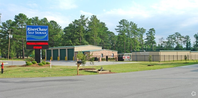
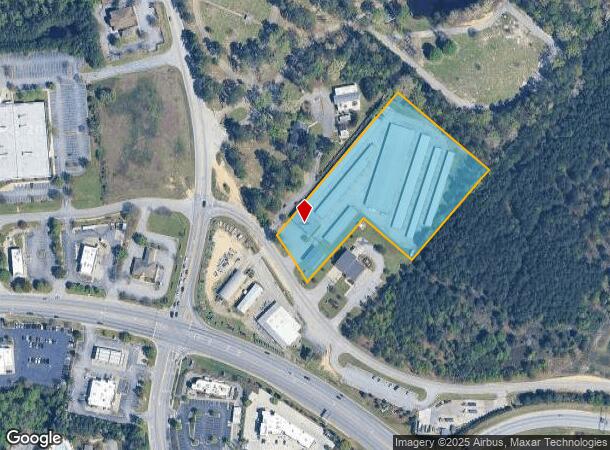
115 Riverchase Way
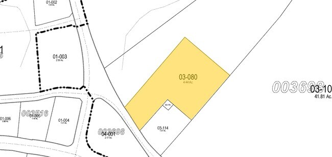
003698-03-080
PARCEL A
Publicstorage
Lexington
X
South Carolina
45063C0144J
4.44 AC
2025
Lexington
2024
Columbia
020506
Columbia, SC
1,150 SF
DEMOGRAPHICS near 115 Riverchase Way
1 Mile
3 Mile
5 Mile
2024 Total Population
2,438
39,996
128,033
2029 Population
2,647
43,433
136,661
Pop Growth 2024-2029
+ 8.57%
+ 8.59%
+ 6.74%
Average Age
38
40
40
2024 Total Households
950
16,768
53,852
HH Growth 2024-2029
+ 8.84%
+ 8.71%
+ 6.91%
Median Household Inc
$75,543
$64,752
$58,301
Avg Household Size
2.50
2.30
2.20
2024 Avg HH Vehicles
2.00
2.00
2.00
Median Home Value
$199,198
$190,480
$173,918
Median Year Built
1995
1985
1983
Nearby Places
Map Layers
Map Styles
 Street
 Aerial
- Restaurants
- Banks
- Shops
- Fitness
- Groceries
PUBLIC TRANSPORTATION
COMMUTER RAIL
Columbia Amtrak Station (Silver Star - Amtrak)
DRIVE
WALK
Distance
Columbia Amtrak Station (Silver Star - Amtrak)
13 min
7.1 mi
AIRPORT
Columbia Metro
DRIVE
WALK
Distance
Columbia Metro
22 min
10.4 mi
Freight Ports
North Charleston Terminal
DRIVE
WALK
Distance
North Charleston Terminal
121 min
106.7 mi
Nearby Properties
Address
Land Use
TOTAL SIZE
Lot Size
Zoning
Address
Land Use
TOTAL SIZE
Lot Size
Zoning
44,296 SF
14.01 AC
GC
Address
Land Use
TOTAL SIZE
Lot Size
Zoning
82,874 SF
6.99 AC
GC
Address
Land Use
TOTAL SIZE
Lot Size
Zoning
78,288 SF
5.14 AC
GC
Address
Land Use
TOTAL SIZE
Lot Size
Zoning
208,016 SF
14.28 AC
GC
Address
Land Use
TOTAL SIZE
Lot Size
Zoning
58,664 SF
6.01 AC
Address
Land Use
TOTAL SIZE
Lot Size
Zoning
31,892 SF
2.23 AC
GC
Address
Land Use
TOTAL SIZE
Lot Size
Zoning
21,475 SF
4.97 AC
GC
Address
Land Use
TOTAL SIZE
Lot Size
Zoning
60,085 SF
2.35 AC
GC
Address
Land Use
TOTAL SIZE
Lot Size
Zoning
10,200 SF
1.73 AC
GC
Address
Land Use
TOTAL SIZE
Lot Size
Zoning
34,841 SF
2.01 AC
GC
Address
Land Use
TOTAL SIZE
Lot Size
Zoning
17,055 SF
2.25 AC
GC
Address
Land Use
TOTAL SIZE
Lot Size
Zoning
8,330 SF
19.10 AC
ID
Address
Land Use
TOTAL SIZE
Lot Size
Zoning
3,080 SF
18.07 AC
R
Address
Land Use
TOTAL SIZE
Lot Size
Zoning
20,360 SF
1.63 AC
GC
Address
Land Use
TOTAL SIZE
Lot Size
Zoning
183,776 SF
18.23 AC
C2
Address
Land Use
TOTAL SIZE
Lot Size
Zoning
3,447 SF
10.03 AC
R3
Address
Land Use
TOTAL SIZE
Lot Size
Zoning
4,658 SF
0.66 AC
GC
Address
Land Use
TOTAL SIZE
Lot Size
Zoning
6,794 SF
6.17 AC
R1
Address
Land Use
TOTAL SIZE
Lot Size
Zoning
190,570 SF
10.01 AC
C2
Address
Land Use
TOTAL SIZE
Lot Size
Zoning
3,824 SF
29.99 AC
R3
Address
Land Use
TOTAL SIZE
Lot Size
Zoning
9,268 SF
15.89 AC
C2
Address
Land Use
TOTAL SIZE
Lot Size
Zoning
7,104 SF
0.91 AC
GC
Address
Land Use
TOTAL SIZE
Lot Size
Zoning
99,628 SF
13.09 AC
RD
Address
Land Use
TOTAL SIZE
Lot Size
Zoning
14,309 SF
1.84 AC
GC
Address
Land Use
TOTAL SIZE
Lot Size
Zoning
153,351 SF
13.33 AC
RD
Address
Land Use
TOTAL SIZE
Lot Size
Zoning
2,192 SF
7.40 AC
ID
Address
Land Use
TOTAL SIZE
Lot Size
Zoning
85,600 SF
22.08 AC
Address
Land Use
TOTAL SIZE
Lot Size
Zoning
7,383 SF
4.85 AC
ID
Address
Land Use
TOTAL SIZE
Lot Size
Zoning
146,960 SF
9.70 AC
C2
Address
Land Use
TOTAL SIZE
Lot Size
Zoning
126,000 SF
8.89 AC
The World's #1 Commercial Real Estate Marketplace
Connect with us
© 2025 CoStar Group
The information above has been obtained from sources believed reliable. While we do not doubt its accuracy we have not verified it and make no guarantee, warranty or representation about it. It is your responsibility to independently confirm its accuracy and completeness. Any projections, opinions, assumptions, or estimates used are for example only and do not represent the current or future performance of the property. The value of this transaction to you depends on tax and other factors which should be evaluated by your tax, financial, and legal advisors. You and your advisors should conduct a careful, independent investigation of the property to determine to your satisfaction the suitability of the property for your needs.