Property Record
115 S Mustian St, Kill Devil Hills, NC 27948

Save to a Folder
{{folder.Name}}
{{folder.ListingIds.length}} Properties
{{folder.ListingIds.length}} Property
Create a New Folder
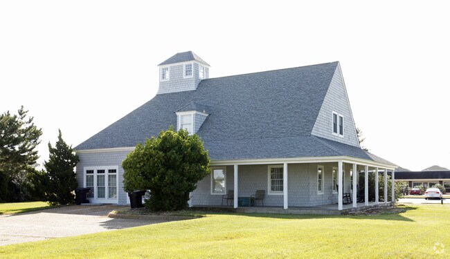
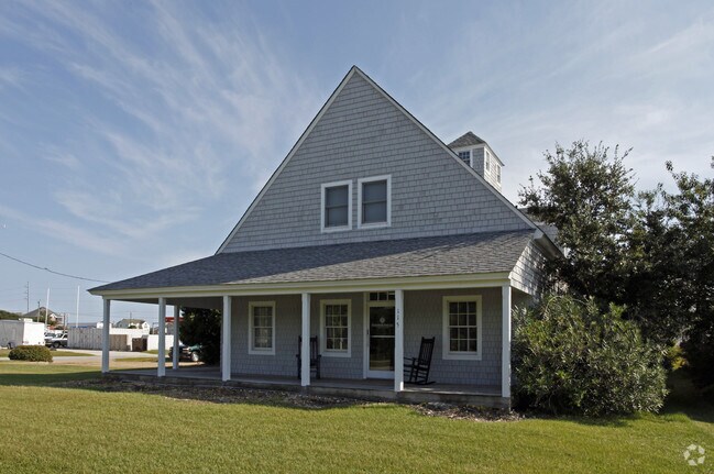
Property Detail
115 S Mustian St
029822009
LOT: 9,10 BLK: 64 SEC: PL: 1 SL: 126
Officebuilding
DARE
B and X Area of moderate flood hazard, usually the area between the limits of the 100-year and 500-year floods.
North Carolina
0
9,10
2025
0.25 AC
970200
Other Market Areas
2,718 SF
Kill Devil Hills, NC
NEARBY LISTINGS FOR SALE OR LEASE
DEMOGRAPHICS near 115 S Mustian St
1 mile
3 mile
5 mile
2025 Total Population
2,389
12,523
18,646
2030 Population
2,447
12,967
19,243
Pop Growth 2025-2030
+ 2.43%
+ 3.55%
+ 3.20%
Average Age
43
44
45
2025 Total Households
1,003
5,360
8,026
HH Growth 2025-2030
+ 2.69%
+ 3.60%
+ 3.23%
Median Household Inc
$73,514
$75,216
$79,059
Avg Household Size
2.30
2.30
2.30
2025 Avg HH Vehicles
2.00
2.00
2.00
Median Home Value
$426,823
$401,972
$420,131
Median Year Built
1985
1985
1985
Nearby Places
Map Layers
Map Styles
 Street
 Aerial
Layers
 Traffic
 Biking
Places
Listings with unknown addresses are not visible on the map
- Restaurants
- Banks
- Shops
- Fitness
- Groceries
Nearby Properties
Address
Land Use
TOTAL SIZE
Lot Size
Zoning
Address
Land Use
TOTAL SIZE
Lot Size
Zoning
9,904 SF
403.08 AC
Address
Land Use
TOTAL SIZE
Lot Size
Zoning
55,053 SF
62.05 AC
Address
Land Use
TOTAL SIZE
Lot Size
Zoning
140,367 SF
21.39 AC
Address
Land Use
TOTAL SIZE
Lot Size
Zoning
92,649 SF
10.97 AC
Address
Land Use
TOTAL SIZE
Lot Size
Zoning
44,278 SF
4.70 AC
Address
Land Use
TOTAL SIZE
Lot Size
Zoning
37,116 SF
2.09 AC
Address
Land Use
TOTAL SIZE
Lot Size
Zoning
45,168 SF
7.62 AC
Address
Land Use
TOTAL SIZE
Lot Size
Zoning
84,383 SF
3.29 AC
Address
Land Use
TOTAL SIZE
Lot Size
Zoning
3,588 SF
11.67 AC
Address
Land Use
TOTAL SIZE
Lot Size
Zoning
91,656 SF
3.49 AC
Address
Land Use
TOTAL SIZE
Lot Size
Zoning
Address
Land Use
TOTAL SIZE
Lot Size
Zoning
121,232 SF
12.71 AC
Address
Land Use
TOTAL SIZE
Lot Size
Zoning
284.73 AC
Address
Land Use
TOTAL SIZE
Lot Size
Zoning
Address
Land Use
TOTAL SIZE
Lot Size
Zoning
55,234 SF
7.57 AC
Address
Land Use
TOTAL SIZE
Lot Size
Zoning
108,315 SF
12.55 AC
Address
Land Use
TOTAL SIZE
Lot Size
Zoning
25,248 SF
23.32 AC
Address
Land Use
TOTAL SIZE
Lot Size
Zoning
24,745 SF
3.31 AC
Address
Land Use
TOTAL SIZE
Lot Size
Zoning
Address
Land Use
TOTAL SIZE
Lot Size
Zoning
Address
Land Use
TOTAL SIZE
Lot Size
Zoning
9,072 SF
1.38 AC
Address
Land Use
TOTAL SIZE
Lot Size
Zoning
33,784 SF
19.16 AC
Address
Land Use
TOTAL SIZE
Lot Size
Zoning
46,031 SF
5.07 AC
Address
Land Use
TOTAL SIZE
Lot Size
Zoning
3,460 SF
24.75 AC
Address
Land Use
TOTAL SIZE
Lot Size
Zoning
35,899 SF
6.51 AC
Address
Land Use
TOTAL SIZE
Lot Size
Zoning
53,153 SF
4 AC
Address
Land Use
TOTAL SIZE
Lot Size
Zoning
54,025 SF
2.31 AC
Address
Land Use
TOTAL SIZE
Lot Size
Zoning
119,104 SF
0.14 AC
Address
Land Use
TOTAL SIZE
Lot Size
Zoning
45,876 SF
2.17 AC
Address
Land Use
TOTAL SIZE
Lot Size
Zoning
12,480 SF
8.59 AC
The World's #1 Commercial Real Estate Marketplace
Connect with us
© 2026 CoStar Group
The information above has been obtained from sources believed reliable. While we do not doubt its accuracy we have not verified it and make no guarantee, warranty or representation about it. It is your responsibility to independently confirm its accuracy and completeness. Any projections, opinions, assumptions, or estimates used are for example only and do not represent the current or future performance of the property. The value of this transaction to you depends on tax and other factors which should be evaluated by your tax, financial, and legal advisors. You and your advisors should conduct a careful, independent investigation of the property to determine to your satisfaction the suitability of the property for your needs.